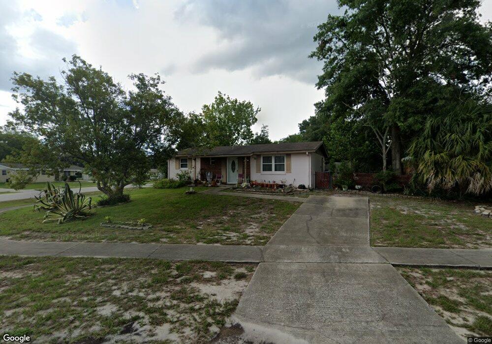
2962 Bond St Deltona, FL 32738
Estimated Value: $198,156 - $238,000
2
Beds
2
Baths
902
Sq Ft
$243/Sq Ft
Est. Value
About This Home
This home is located at 2962 Bond St, Deltona, FL 32738 and is currently estimated at $218,789, approximately $242 per square foot. 2962 Bond St is a home located in Volusia County with nearby schools including Friendship Elementary School, Galaxy Middle School, and Pine Ridge High School.
Ownership History
Date
Name
Owned For
Owner Type
Purchase Details
Closed on
Aug 23, 2000
Sold by
Spitz Harold J and Spitz Beverly D
Bought by
Long Harold L and Long Ada L
Current Estimated Value
Home Financials for this Owner
Home Financials are based on the most recent Mortgage that was taken out on this home.
Original Mortgage
$39,100
Outstanding Balance
$14,027
Interest Rate
8.07%
Mortgage Type
Purchase Money Mortgage
Estimated Equity
$204,762
Purchase Details
Closed on
May 15, 1979
Bought by
Long Harold L and Long Ada L
Purchase Details
Closed on
Jun 15, 1977
Bought by
Long Harold L and Long Ada L
Create a Home Valuation Report for This Property
The Home Valuation Report is an in-depth analysis detailing your home's value as well as a comparison with similar homes in the area
Home Values in the Area
Average Home Value in this Area
Purchase History
| Date | Buyer | Sale Price | Title Company |
|---|---|---|---|
| Long Harold L | $48,900 | -- | |
| Long Harold L | $21,000 | -- | |
| Long Harold L | $24,800 | -- |
Source: Public Records
Mortgage History
| Date | Status | Borrower | Loan Amount |
|---|---|---|---|
| Open | Long Harold L | $39,100 |
Source: Public Records
Tax History Compared to Growth
Tax History
| Year | Tax Paid | Tax Assessment Tax Assessment Total Assessment is a certain percentage of the fair market value that is determined by local assessors to be the total taxable value of land and additions on the property. | Land | Improvement |
|---|---|---|---|---|
| 2025 | $386 | $35,432 | -- | -- |
| 2024 | $386 | $34,434 | -- | -- |
| 2023 | $386 | $33,432 | $0 | $0 |
| 2022 | $481 | $32,458 | $0 | $0 |
| 2021 | $472 | $31,513 | $0 | $0 |
| 2020 | $463 | $31,078 | $0 | $0 |
| 2019 | $453 | $30,379 | $0 | $0 |
| 2018 | $423 | $29,813 | $0 | $0 |
| 2017 | $383 | $29,200 | $0 | $0 |
| 2016 | $367 | $28,599 | $0 | $0 |
| 2015 | $365 | $28,400 | $0 | $0 |
| 2014 | $329 | $28,175 | $0 | $0 |
Source: Public Records
Map
Nearby Homes
- 2361 Kimberly Dr
- 2822 Fulford St
- 2493 Hope Ave
- 2271 Conway Dr
- 2214 Danforth Ave
- 2412 Ainsworth Ave
- 3036 Beal St
- 2837 Sweet Springs St
- 2308 Lake Helen Osteen Rd
- 2450 Cardena Ave
- 2121 Capri Cir
- 2333 Ainsworth Ave
- 2448 Austin Ave
- 3232 Lackland Dr
- 3201 N Tulsa Dr
- 3209 S Dorchester Dr
- 2766 Elkcam Blvd
- 2381 Courtland Blvd
- 2689 Courtland Blvd
- 2332 Hadley St
- 2437 Kimberly Dr
- 2502 E Juliet Dr
- 2510 E Juliet Dr
- 2421 Kimberly Dr
- 2443 Kimberly Dr
- 2432 Kimberly Dr
- 2426 Kimberly Dr
- 2438 Kimberly Dr
- 2518 E Juliet Dr
- 2420 Kimberly Dr
- 2444 Kimberly Dr
- 2415 Kimberly Dr
- 2449 Kimberly Dr
- 2425 Alamanda Ave
- 2419 Alamanda Ave Unit 74
- 2431 Alamanda Ave
- 2414 Kimberly Dr
- 2526 E Juliet Dr
- 2982 Bond St