Estimated Value: $386,000 - $544,000
3
Beds
2
Baths
2,032
Sq Ft
$245/Sq Ft
Est. Value
About This Home
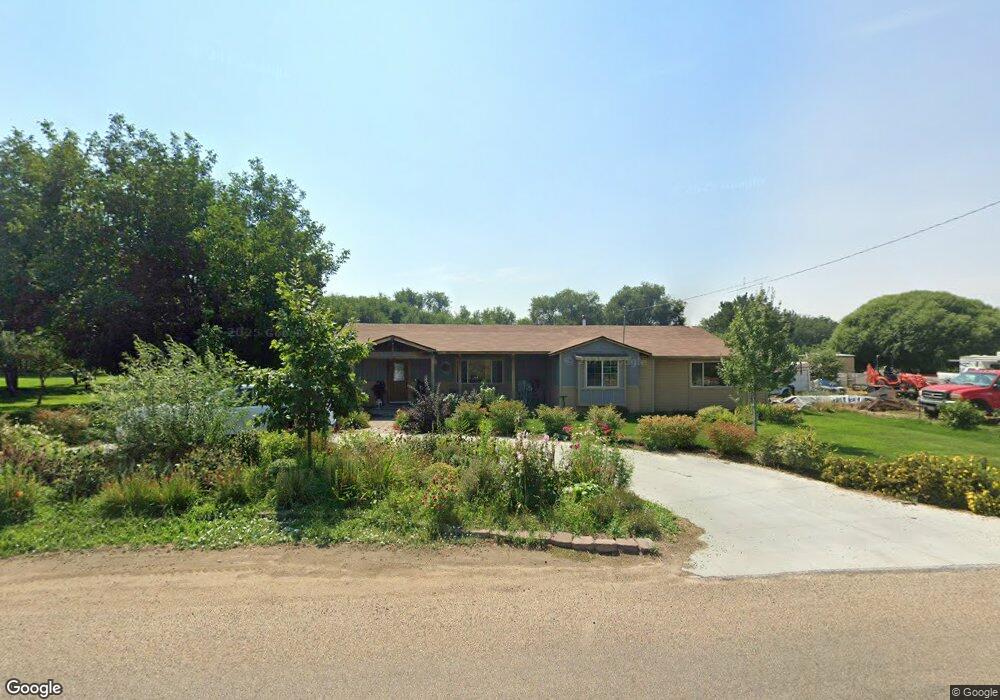
This home is located at 29623 Pearl Rd, Parma, ID 83660 and is currently estimated at $498,806, approximately $245 per square foot. 29623 Pearl Rd is a home located in Canyon County with nearby schools including Maxine Johnson Elementary School, Parma Middle School, and Parma High School.
Ownership History
Date
Name
Owned For
Owner Type
Purchase Details
Closed on
Mar 31, 2021
Sold by
Bojarski Kenneth F and Bojarski Mildred
Bought by
Marlin Michael O and Marlin Meredith
Current Estimated Value
Purchase Details
Closed on
May 1, 2006
Sold by
Bojarski Kenneth F and Bojarski Marie
Bought by
Bojarski Kenneth F and Bojarski Mildred
Home Financials for this Owner
Home Financials are based on the most recent Mortgage that was taken out on this home.
Original Mortgage
$41,250
Interest Rate
6.29%
Mortgage Type
Credit Line Revolving
Create a Home Valuation Report for This Property
The Home Valuation Report is an in-depth analysis detailing your home's value as well as a comparison with similar homes in the area
Home Values in the Area
Average Home Value in this Area
Purchase History
| Date | Buyer | Sale Price | Title Company |
|---|---|---|---|
| Marlin Michael O | -- | First American Title | |
| Bojarski Kenneth F | -- | Pioneer Title Company |
Source: Public Records
Mortgage History
| Date | Status | Borrower | Loan Amount |
|---|---|---|---|
| Previous Owner | Bojarski Kenneth F | $41,250 | |
| Previous Owner | Bojarski Kenneth F | $115,500 |
Source: Public Records
Tax History
| Year | Tax Paid | Tax Assessment Tax Assessment Total Assessment is a certain percentage of the fair market value that is determined by local assessors to be the total taxable value of land and additions on the property. | Land | Improvement |
|---|---|---|---|---|
| 2025 | $1,798 | $493,480 | $201,380 | $292,100 |
| 2024 | $1,798 | $473,080 | $201,380 | $271,700 |
| 2023 | $1,785 | $471,780 | $201,380 | $270,400 |
| 2022 | $2,192 | $473,280 | $205,880 | $267,400 |
| 2021 | $1,634 | $305,030 | $96,030 | $209,000 |
| 2020 | $1,389 | $223,060 | $61,460 | $161,600 |
| 2019 | $1,409 | $210,560 | $52,060 | $158,500 |
| 2018 | $1,398 | $0 | $0 | $0 |
| 2017 | $1,340 | $0 | $0 | $0 |
| 2016 | $1,189 | $0 | $0 | $0 |
| 2015 | $1,123 | $0 | $0 | $0 |
| 2014 | $1,043 | $129,150 | $38,050 | $91,100 |
Source: Public Records
Map
Nearby Homes
- 29410 Pearl Rd
- TBD Ada Ln
- 0 Leigh Ln
- 31854 Apple Valley Rd
- TBD Stubb Ln
- 0 Stubb Ln
- Lot 3 Hurtz Ln
- Lot 1 Hurtz Ln
- Lot 2 Hurtz Ln
- Lot 4 Hurtz Ln
- 28279 & 28283 Pearl Rd
- 28283 Pearl Rd
- 28279 Pearl Rd
- 28750 Rocky Rd
- TBD Sunset View Road (Lot 5)
- 1203 Locker Ave
- 813 Reece Ave
- 112 E Main St
- 106 E Main St
- 108 E Main St
Your Personal Tour Guide
Ask me questions while you tour the home.