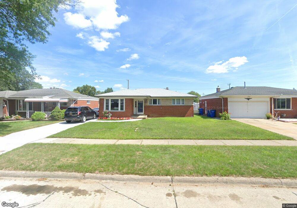
29624 Dover Ave Warren, MI 48088
Northeast Warren NeighborhoodEstimated Value: $239,559 - $255,000
3
Beds
2
Baths
1,289
Sq Ft
$194/Sq Ft
Est. Value
About This Home
This home is located at 29624 Dover Ave, Warren, MI 48088 and is currently estimated at $250,140, approximately $194 per square foot. 29624 Dover Ave is a home located in Macomb County with nearby schools including Warren Woods Tower High School, Frontier International Academy Elementary, and Warren Woods Christian School.
Ownership History
Date
Name
Owned For
Owner Type
Purchase Details
Closed on
Nov 4, 2020
Sold by
Vaught Mark C
Bought by
Sarosik Jay
Current Estimated Value
Purchase Details
Closed on
Feb 15, 2005
Sold by
Kennedy Michelle and Bandy Michelle
Bought by
Sarosik Jay
Purchase Details
Closed on
Apr 28, 2004
Sold by
Vaught Mark C and Vaught Michelle M
Bought by
Bandy Michelle
Purchase Details
Closed on
Oct 24, 2003
Sold by
Vaught Mark C and Vaught Michelle M
Bought by
Paramount Bank
Create a Home Valuation Report for This Property
The Home Valuation Report is an in-depth analysis detailing your home's value as well as a comparison with similar homes in the area
Home Values in the Area
Average Home Value in this Area
Purchase History
| Date | Buyer | Sale Price | Title Company |
|---|---|---|---|
| Sarosik Jay | -- | None Available | |
| Sarosik Jay | $156,000 | First American Title Ins Co | |
| Bandy Michelle | $164,000 | -- | |
| Paramount Bank | $22,669 | -- |
Source: Public Records
Tax History
| Year | Tax Paid | Tax Assessment Tax Assessment Total Assessment is a certain percentage of the fair market value that is determined by local assessors to be the total taxable value of land and additions on the property. | Land | Improvement |
|---|---|---|---|---|
| 2025 | $3,168 | $113,810 | $0 | $0 |
| 2024 | $31 | $103,260 | $0 | $0 |
| 2023 | $2,921 | $96,000 | $0 | $0 |
| 2022 | $2,864 | $83,820 | $0 | $0 |
| 2021 | $2,810 | $76,910 | $0 | $0 |
| 2020 | $2,693 | $72,590 | $0 | $0 |
| 2019 | $2,573 | $68,500 | $0 | $0 |
| 2018 | $77 | $62,130 | $0 | $0 |
| 2017 | $2,458 | $55,710 | $9,990 | $45,720 |
| 2016 | $2,439 | $55,710 | $0 | $0 |
| 2015 | $1,429 | $49,480 | $0 | $0 |
| 2012 | -- | $47,120 | $0 | $0 |
Source: Public Records
Map
Nearby Homes
- 30032 Iroquois Dr
- 30045 Iroquois Dr
- 29820 Palomino Dr
- 12531 Common Rd
- 29143 Dover Ave
- 54765 Palomino Ave
- 30806 Ridgefield Ave
- 30829 Eiffel Ave
- 30139 Flanders Ave
- 30745 Iroquois Dr
- 29454 Scarborough Dr Unit 7
- 29105 Palomino Dr
- 29337 Roan Dr
- 29366 Wagner Dr
- 14135 Ivanhoe Dr
- 13209 E 13 Mile Rd
- 30955 Iroquois Dr
- 14066 Castle Ave
- 13342 Lutz Ave
- 29134 Bonnie Dr
- 29636 Dover Ave
- 29612 Dover Ave
- 29648 Dover Ave
- 29600 Dover Ave
- 29660 Dover Ave
- 29588 Dover Ave
- 29625 Dover Ave
- 29637 Dover Ave
- 29615 Dover Ave
- 29672 Dover Ave Unit Bldg-Unit
- 29672 Dover Ave
- 29576 Dover Ave
- 29601 Dover Ave
- 29661 Dover Ave
- 29587 Dover Ave
- 29564 Dover Ave
- 29673 Dover Ave
- 29575 Dover Ave
- 13122 Walter Ave
- 13110 Walter Ave
Your Personal Tour Guide
Ask me questions while you tour the home.