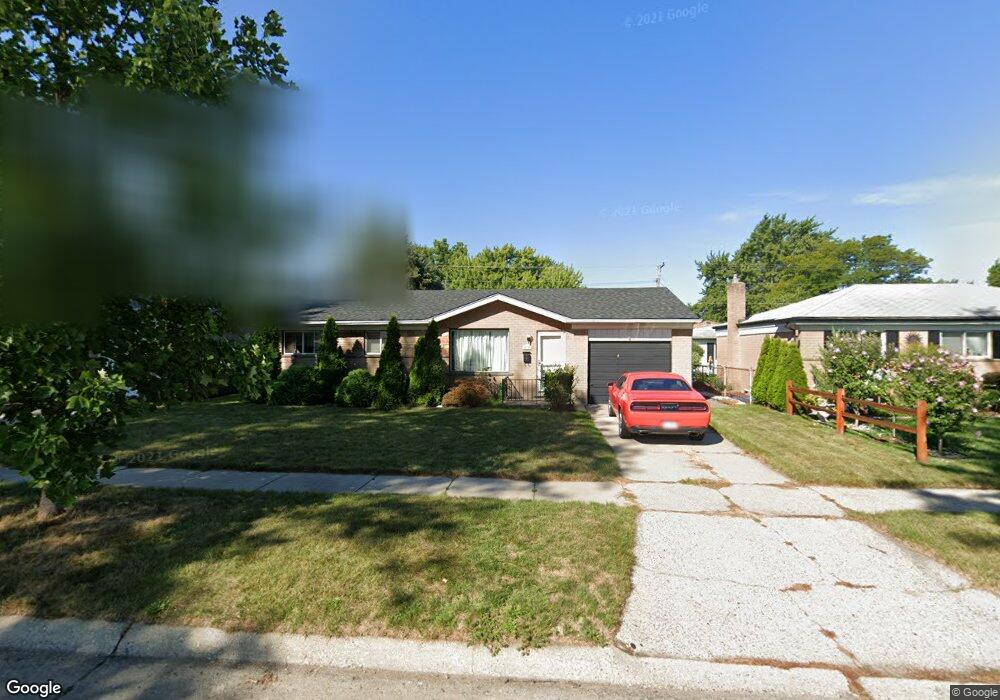
29639 Malvina Dr Warren, MI 48088
Northeast Warren NeighborhoodEstimated Value: $227,000 - $239,000
3
Beds
1
Bath
1,056
Sq Ft
$218/Sq Ft
Est. Value
About This Home
This home is located at 29639 Malvina Dr, Warren, MI 48088 and is currently estimated at $230,717, approximately $218 per square foot. 29639 Malvina Dr is a home located in Macomb County with nearby schools including Warren Woods Tower High School, Frontier International Academy Elementary, and Warren Woods Christian School.
Ownership History
Date
Name
Owned For
Owner Type
Purchase Details
Closed on
Jan 16, 2008
Sold by
Bank Of New York
Bought by
Deutsche Bank National Trust Co and Morgan Stanley Abs Capital I Inc Trust 2
Current Estimated Value
Purchase Details
Closed on
Sep 28, 2007
Sold by
New Century Mortgage Corp
Bought by
Deutsche Bank National Trust Co and Morgan Stanley Abs Capital 1 Inc Trust 2
Purchase Details
Closed on
Mar 16, 2007
Sold by
Saputo Domenico and Saputo Rose B
Bought by
Charter One Bank F S B
Purchase Details
Closed on
Jul 28, 2006
Sold by
Barr Edward
Bought by
New Century Mortgage Corp
Purchase Details
Closed on
May 15, 2001
Sold by
Saputo Domenico
Bought by
Barr Edward
Create a Home Valuation Report for This Property
The Home Valuation Report is an in-depth analysis detailing your home's value as well as a comparison with similar homes in the area
Home Values in the Area
Average Home Value in this Area
Purchase History
| Date | Buyer | Sale Price | Title Company |
|---|---|---|---|
| Deutsche Bank National Trust Co | -- | E Title | |
| Deutsche Bank National Trust Co | -- | None Available | |
| Charter One Bank F S B | $18,740 | None Available | |
| New Century Mortgage Corp | $167,263 | None Available | |
| Barr Edward | $138,000 | -- |
Source: Public Records
Tax History
| Year | Tax Paid | Tax Assessment Tax Assessment Total Assessment is a certain percentage of the fair market value that is determined by local assessors to be the total taxable value of land and additions on the property. | Land | Improvement |
|---|---|---|---|---|
| 2025 | $2,597 | $102,730 | $0 | $0 |
| 2024 | $25 | $93,340 | $0 | $0 |
| 2023 | $2,395 | $90,130 | $0 | $0 |
| 2022 | $2,348 | $78,470 | $0 | $0 |
| 2021 | $2,304 | $71,830 | $0 | $0 |
| 2020 | $2,208 | $67,640 | $0 | $0 |
| 2019 | $2,109 | $64,710 | $0 | $0 |
| 2018 | $2,131 | $53,640 | $0 | $0 |
| 2017 | $2,015 | $48,290 | $10,170 | $38,120 |
| 2016 | $2,000 | $48,290 | $0 | $0 |
| 2015 | -- | $43,740 | $0 | $0 |
| 2013 | $3,864 | $37,810 | $0 | $0 |
Source: Public Records
Map
Nearby Homes
- 29454 Scarborough Dr Unit 7
- 14135 Ivanhoe Dr
- 30139 Flanders Ave
- 29143 Dover Ave
- 14066 Castle Ave
- 30045 Iroquois Dr
- 28771 Bunert Rd
- 14108 La Chene Ave
- 30806 Ridgefield Ave
- 30310 Valenti Dr
- 30829 Eiffel Ave
- 29820 Palomino Dr
- 12531 Common Rd
- 54765 Palomino Ave
- 29105 Palomino Dr
- 29200 Gloede Dr Unit 135
- 30745 Iroquois Dr
- 13209 E 13 Mile Rd
- 13342 Lutz Ave
- 29337 Roan Dr
- 29627 Malvina Dr
- 29653 Malvina Dr
- 13652 Matilda Ave
- 29615 Malvina Dr
- 13655 Irene Ct
- 13640 Matilda Ave
- 13643 Irene Ct
- 29640 Malvina Dr
- 29628 Malvina Dr
- 29654 Malvina Dr
- 29709 Malvina Dr
- 13628 Matilda Ave
- 29616 Malvina Dr
- 13631 Irene Ct
- 13653 Matilda Ave
- 13616 Matilda Ave
- 29604 Malvina Dr
- 29453 Malvina Dr
- 29721 Malvina Dr
- 29710 Malvina Dr
Your Personal Tour Guide
Ask me questions while you tour the home.