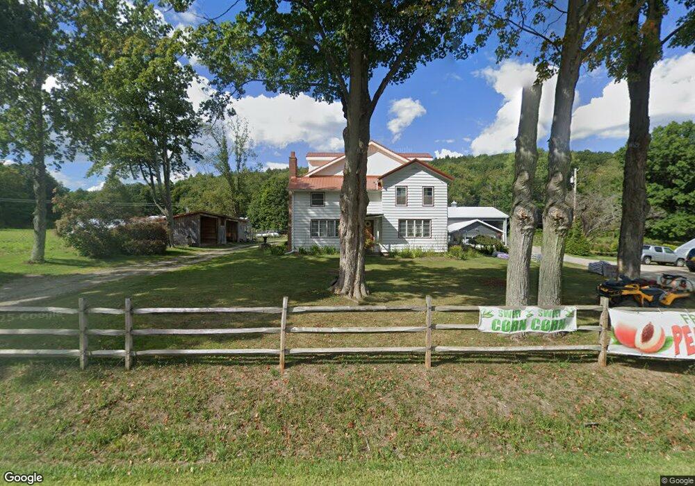
2965 State Route 21 Wayland, NY 14572
Estimated Value: $196,000 - $303,431
3
Beds
1
Bath
2,050
Sq Ft
$123/Sq Ft
Est. Value
About This Home
This home is located at 2965 State Route 21, Wayland, NY 14572 and is currently estimated at $251,858, approximately $122 per square foot. 2965 State Route 21 is a home located in Steuben County with nearby schools including Wayland Cohocton Middle School and Wayland Cohocton High School.
Ownership History
Date
Name
Owned For
Owner Type
Purchase Details
Closed on
Sep 12, 2013
Sold by
Nagle Carol-Lee
Bought by
Logsdon Brian
Current Estimated Value
Home Financials for this Owner
Home Financials are based on the most recent Mortgage that was taken out on this home.
Original Mortgage
$142,500
Outstanding Balance
$106,464
Interest Rate
4.43%
Mortgage Type
Purchase Money Mortgage
Estimated Equity
$145,394
Purchase Details
Closed on
May 6, 2011
Sold by
Nagle Carol-Lee
Bought by
Ferringer David R
Create a Home Valuation Report for This Property
The Home Valuation Report is an in-depth analysis detailing your home's value as well as a comparison with similar homes in the area
Home Values in the Area
Average Home Value in this Area
Purchase History
| Date | Buyer | Sale Price | Title Company |
|---|---|---|---|
| Logsdon Brian | $150,000 | -- | |
| Ferringer David R | $20,000 | Erie Shults |
Source: Public Records
Mortgage History
| Date | Status | Borrower | Loan Amount |
|---|---|---|---|
| Open | Logsdon Brian | $142,500 |
Source: Public Records
Tax History Compared to Growth
Tax History
| Year | Tax Paid | Tax Assessment Tax Assessment Total Assessment is a certain percentage of the fair market value that is determined by local assessors to be the total taxable value of land and additions on the property. | Land | Improvement |
|---|---|---|---|---|
| 2024 | $4,916 | $190,700 | $49,200 | $141,500 |
| 2023 | $4,865 | $190,700 | $49,200 | $141,500 |
| 2022 | $5,434 | $190,700 | $49,200 | $141,500 |
| 2021 | $5,539 | $179,900 | $47,300 | $132,600 |
| 2020 | $4,292 | $155,900 | $47,300 | $108,600 |
| 2019 | $809 | $155,900 | $47,300 | $108,600 |
| 2018 | $4,315 | $155,900 | $47,300 | $108,600 |
| 2017 | $4,059 | $148,600 | $45,800 | $102,800 |
| 2016 | $3,922 | $148,600 | $45,800 | $102,800 |
| 2015 | -- | $148,600 | $45,800 | $102,800 |
| 2014 | -- | $143,700 | $45,800 | $97,900 |
Source: Public Records
Map
Nearby Homes
- 107 East Ave
- 102 East Ave
- 300 E Naples St
- 223 Lincoln St
- 0 Yocum Rd
- 0 Route 21 S
- 306 Fremont St
- 8471 Alpaugh Rd
- 8868 Pardee Hollow Rd
- 7636 Lime Kiln Rd
- 2057 New York 63
- 4116 State Route 21
- 11797 Reservoir Rd
- 9092 Carney Hollow Rd
- 0 Lanning Rd
- 8 Erie St
- 1651 State Route 63
- 9000 Garlinghouse Atlanta Rd
- 7524 East Ave
- 3026 Emo Rd
- 2988 State Route 21
- 2926 State Route 21
- 2990 Woodham Rd
- 3035 State Route 21
- 2897 Cr 21
- 3049 State Route 21
- 3031 Woodham Rd
- 2847 State Route 21
- 3088 State Route 21
- 11789 Schrader Rd
- 11845 Schrader Rd
- 2778 State Route 21
- 9192 Schwab Hollow Rd
- 2776 State Route 21
- 2768 State Route 21
- 2775 State Route 21
- 9190 Schwab Hollow Rd
- 2764 State Route 21
- 3150 State Route 21
- 2767 State Route 21