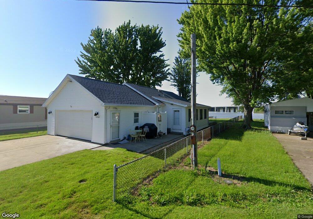
2965 W Wayne Rd Port Clinton, OH 43452
Estimated Value: $259,011 - $302,000
2
Beds
1
Bath
936
Sq Ft
$304/Sq Ft
Est. Value
About This Home
This home is located at 2965 W Wayne Rd, Port Clinton, OH 43452 and is currently estimated at $285,003, approximately $304 per square foot. 2965 W Wayne Rd is a home located in Ottawa County with nearby schools including Bataan Memorial Primary School, Bataan Memorial Intermediate School, and Port Clinton Middle School.
Ownership History
Date
Name
Owned For
Owner Type
Purchase Details
Closed on
Jan 7, 2015
Sold by
Pezzutti David L and Pezzutti Mary L
Bought by
Pezzutti David L and David Larry Pezzutti Trust
Current Estimated Value
Purchase Details
Closed on
Apr 11, 2011
Sold by
Johnston Theodore E
Bought by
Pezzutti David L and Pezzutti Mary L
Purchase Details
Closed on
Dec 9, 2009
Sold by
Bell Patricia A
Bought by
Johnston Theodore E
Home Financials for this Owner
Home Financials are based on the most recent Mortgage that was taken out on this home.
Original Mortgage
$120,000
Interest Rate
5.11%
Mortgage Type
New Conventional
Purchase Details
Closed on
Jun 22, 1993
Sold by
Pratt Benjamin and Pratt Virginia
Bought by
Bell Chas E and Bell Patricia A S
Create a Home Valuation Report for This Property
The Home Valuation Report is an in-depth analysis detailing your home's value as well as a comparison with similar homes in the area
Home Values in the Area
Average Home Value in this Area
Purchase History
| Date | Buyer | Sale Price | Title Company |
|---|---|---|---|
| Pezzutti David L | -- | Attorney | |
| Pezzutti David L | $157,000 | Hartung Title | |
| Johnston Theodore E | $154,500 | Hartung Title | |
| Bell Chas E | $65,000 | -- |
Source: Public Records
Mortgage History
| Date | Status | Borrower | Loan Amount |
|---|---|---|---|
| Previous Owner | Johnston Theodore E | $120,000 |
Source: Public Records
Tax History Compared to Growth
Tax History
| Year | Tax Paid | Tax Assessment Tax Assessment Total Assessment is a certain percentage of the fair market value that is determined by local assessors to be the total taxable value of land and additions on the property. | Land | Improvement |
|---|---|---|---|---|
| 2024 | $2,585 | $78,618 | $34,199 | $44,419 |
| 2023 | $2,585 | $44,653 | $24,430 | $20,223 |
| 2022 | $1,626 | $44,653 | $24,430 | $20,223 |
| 2021 | $1,624 | $44,650 | $24,430 | $20,220 |
| 2020 | $1,706 | $44,930 | $23,720 | $21,210 |
| 2019 | $1,680 | $44,930 | $23,720 | $21,210 |
| 2018 | $1,677 | $44,930 | $23,720 | $21,210 |
| 2017 | $1,668 | $46,300 | $23,720 | $22,580 |
| 2016 | $1,672 | $46,300 | $23,720 | $22,580 |
| 2015 | $1,679 | $46,300 | $23,720 | $22,580 |
| 2014 | $1,698 | $46,300 | $23,720 | $22,580 |
| 2013 | $1,698 | $46,300 | $23,720 | $22,580 |
Source: Public Records
Map
Nearby Homes
- 2915 W Risingsun Rd
- 2915 W Rising Sun Rd
- 2860 W Rising Sun Rd
- 2400 Sandy Ln
- 3652 W Harbor Rd
- 1805 W Lakeshore Dr
- 3800 W Lakeshore Dr
- 51 N Schooner Point Dr
- 85 Schooner Point Dr
- 1340 W Lakeshore Dr Unit 1372
- 1090 W Richey Rd
- 5372 W Harbor Rd
- 1254 W Fremont Rd
- 439 Erie Ct
- 304 Clinton Reef Dr
- 306 Clinton Reef Dr Unit 306
- 224 Clinton Reef Dr Unit 224
- 208 Clinton Reef Dr Unit 208
- 172 Clinton Reef Dr
- 711 W Lakeshore Dr Unit 408C
- 2965 W Wayne St
- 2925 W Risingsun Rd
- 2925 W Risingsun Rd
- 2915 W Wayne Rd
- 2965 W Risingsun Rd
- 2965 W Rising Sun Rd
- 3015 W Wayne Rd
- 3025 W Wayne Rd
- 3025 W Wayne St
- 2995 W Risingsun Rd
- 2895 W Rising Sun Rd
- 2885 W Wayne Rd
- 3035 W Wayne Rd
- 3035 W Wayne St
- 2885 W Risingsun Rd
- 2900 W Rising Sun Rd
- 3045 W Wayne Rd
- 2900 W Risingsun Rd
- 3055 W Wayne Rd
- 2890 W Risingsun Rd