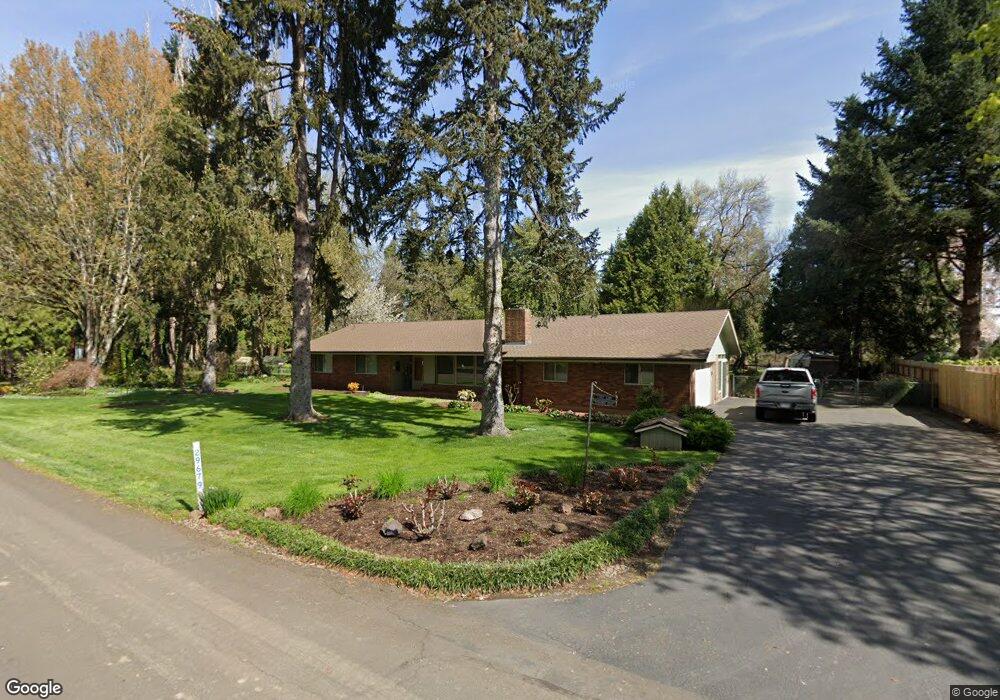
29679 SE Shady Oak Dr Corvallis, OR 97333
Estimated Value: $735,198 - $796,000
3
Beds
2
Baths
1,821
Sq Ft
$420/Sq Ft
Est. Value
About This Home
This home is located at 29679 SE Shady Oak Dr, Corvallis, OR 97333 and is currently estimated at $765,599, approximately $420 per square foot. 29679 SE Shady Oak Dr is a home located in Linn County with nearby schools including Garfield Elementary School, Linus Pauling Middle School, and Corvallis High School.
Ownership History
Date
Name
Owned For
Owner Type
Purchase Details
Closed on
Dec 21, 2022
Sold by
Davis Family Trust
Bought by
Anderson Jonathan Richard and Anderson Marci Christine
Current Estimated Value
Home Financials for this Owner
Home Financials are based on the most recent Mortgage that was taken out on this home.
Original Mortgage
$370,600
Outstanding Balance
$358,703
Interest Rate
6.58%
Mortgage Type
New Conventional
Estimated Equity
$406,896
Purchase Details
Closed on
Apr 28, 2014
Sold by
Davis William Michasel and Davis Patricia A
Bought by
Davis William Michael and Davis Patricia A
Create a Home Valuation Report for This Property
The Home Valuation Report is an in-depth analysis detailing your home's value as well as a comparison with similar homes in the area
Home Values in the Area
Average Home Value in this Area
Purchase History
| Date | Buyer | Sale Price | Title Company |
|---|---|---|---|
| Anderson Jonathan Richard | $700,000 | Amerititle | |
| Davis William Michael | -- | None Available |
Source: Public Records
Mortgage History
| Date | Status | Borrower | Loan Amount |
|---|---|---|---|
| Open | Anderson Jonathan Richard | $370,600 |
Source: Public Records
Tax History Compared to Growth
Tax History
| Year | Tax Paid | Tax Assessment Tax Assessment Total Assessment is a certain percentage of the fair market value that is determined by local assessors to be the total taxable value of land and additions on the property. | Land | Improvement |
|---|---|---|---|---|
| 2024 | $5,625 | $395,650 | -- | -- |
| 2023 | $5,465 | $384,130 | $0 | $0 |
| 2022 | $5,408 | $372,950 | $0 | $0 |
| 2021 | $5,025 | $362,090 | $0 | $0 |
| 2020 | $4,982 | $351,550 | $0 | $0 |
| 2019 | $4,875 | $341,320 | $0 | $0 |
| 2018 | $4,756 | $331,380 | $0 | $0 |
| 2017 | $4,616 | $321,730 | $0 | $0 |
| 2016 | $4,142 | $312,360 | $0 | $0 |
| 2015 | $4,045 | $302,730 | $0 | $0 |
| 2014 | $4,164 | $303,270 | $0 | $0 |
Source: Public Records
Map
Nearby Homes
- 33125 SE White Oak (#20) Rd Unit 20
- 33125 SE White Oak (#1) Rd Unit 1
- 33125 SE White Oak (#56) Rd Unit 56
- 33125 SE White Oak Rd Unit 5 Rd
- 33125 SE White Oak Rd Unit 21 Rd
- 33125 SE White Oak Rd Unit 17
- 33321 SE Peoria Rd
- 32642 Peoria Rd SW
- 33844 SE White Oak Rd
- 29509 NE Pheasant Ave
- 34123 Cushman Rd Unit 1400
- 34123 Cushman Rd Unit 1300
- 34123 Cushman Rd Unit 3 Lots
- 34123 Cushman Rd Unit 1200
- (Near 34123) Rd
- (Near 34123) Cushman (Lot 1400) Rd
- (Near 34123) Cushman (Lot 1300) Rd
- (Near 34123) Cushman (Lot 1200) Rd
- 34505 Riverside Dr SW
- 1249 SE Rivergreen Ave
- 29697 SE Shady Oak Dr
- 29668 SE Shady Oak Dr
- 29700 SE Shady Oak Dr
- 29658 SE Shady Oak Dr
- 29657 SE Shady Oak Dr
- 29703 SE Shady Oak Dr
- 33198 SE White Pine Rd
- 33170 SE White Pine Rd
- 29710 SE Shady Oak Dr
- 29686 SE Meadow Lark Dr
- 29714 SE Meadow Lark Dr
- 33162 SE White Pine Rd
- 33209 SE Primrose Rd
- 29640 SE Shady Oak Dr
- 33185 White Pine Rd
- 33159 White Pine Rd
- 0 SE White Pine Rd Unit 695005
- 0 SE White Pine Rd Unit 695094
- 0 SE White Pine Rd Unit 695181
- 29755 SE Shady Oak Dr