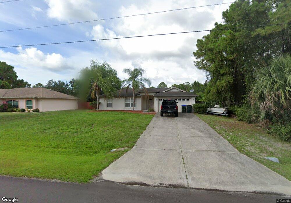
2968 Barry Rd North Port, FL 34286
Estimated Value: $250,841 - $327,000
3
Beds
2
Baths
1,300
Sq Ft
$216/Sq Ft
Est. Value
About This Home
This home is located at 2968 Barry Rd, North Port, FL 34286 and is currently estimated at $280,960, approximately $216 per square foot. 2968 Barry Rd is a home located in Sarasota County with nearby schools including North Port High School, Lamarque Elementary School, and Woodland Middle School.
Ownership History
Date
Name
Owned For
Owner Type
Purchase Details
Closed on
Jun 15, 2005
Sold by
Tarlowski Robert
Bought by
Saunders Harold H and Saunders Shirley A
Current Estimated Value
Home Financials for this Owner
Home Financials are based on the most recent Mortgage that was taken out on this home.
Original Mortgage
$165,675
Outstanding Balance
$85,935
Interest Rate
5.66%
Mortgage Type
Fannie Mae Freddie Mac
Estimated Equity
$195,025
Purchase Details
Closed on
Nov 4, 2003
Sold by
Perin William E and Perin Nancy R
Bought by
Tarlowski Robert
Purchase Details
Closed on
Sep 25, 2003
Sold by
Butcher Carolyn R
Bought by
Perin William E and Perin Nancy R
Create a Home Valuation Report for This Property
The Home Valuation Report is an in-depth analysis detailing your home's value as well as a comparison with similar homes in the area
Home Values in the Area
Average Home Value in this Area
Purchase History
| Date | Buyer | Sale Price | Title Company |
|---|---|---|---|
| Saunders Harold H | $220,900 | Riddelltitle & Escrow Llc | |
| Tarlowski Robert | $9,500 | -- | |
| Perin William E | $3,000 | -- |
Source: Public Records
Mortgage History
| Date | Status | Borrower | Loan Amount |
|---|---|---|---|
| Open | Saunders Harold H | $165,675 |
Source: Public Records
Tax History Compared to Growth
Tax History
| Year | Tax Paid | Tax Assessment Tax Assessment Total Assessment is a certain percentage of the fair market value that is determined by local assessors to be the total taxable value of land and additions on the property. | Land | Improvement |
|---|---|---|---|---|
| 2024 | $3,552 | $197,457 | -- | -- |
| 2023 | $3,552 | $219,600 | $15,900 | $203,700 |
| 2022 | $3,558 | $222,900 | $19,200 | $203,700 |
| 2021 | $3,010 | $149,600 | $9,700 | $139,900 |
| 2020 | $2,843 | $138,000 | $9,700 | $128,300 |
| 2019 | $2,747 | $137,900 | $9,200 | $128,700 |
| 2018 | $2,469 | $130,600 | $9,000 | $121,600 |
| 2017 | $2,362 | $105,763 | $0 | $0 |
| 2016 | $2,209 | $111,600 | $5,000 | $106,600 |
| 2015 | $2,036 | $93,300 | $4,300 | $89,000 |
| 2014 | $1,887 | $72,237 | $0 | $0 |
Source: Public Records
Map
Nearby Homes
- 2967 Barry Rd
- 2931 Barry Rd
- 0958-11-4215 Natural St
- 2969 Wells Ave
- 4610 Clarke St
- 0 Maximo Rd Unit MFRC7505206
- 0 Maximo Rd Unit Lot 27, MFRC7509333
- 0 Lummus St Unit 2025005676
- 0 Lummus St Unit MFRC7497102
- 0 Lummus St Unit 225049848
- 0 Carthage St Unit MFRC7493998
- 0 Carthage St Unit MFRD6144545
- 8 Lummus St
- 2718 Chipley Ave
- 0 Ancient Rd Unit MFRC7514981
- Tbd Snug St
- 13 Snug St
- Lot 11 Sultan Ave
- 0 Moncrief Ave Unit MFRC7514999
- 1135 Moncrief Blk 50 Ave
- 2980 Barry Rd
- 2979 Barry Rd
- 2966 Maximo Rd
- 2978 Maximo Rd
- LOT 16 Barry Rd
- Lot 24 & 25 Barry Rd
- 0 Barry Rd Unit N5904751
- 0958114115 Barry Rd Unit 15
- 0 Barry Rd Unit D5910397
- 5008 N Cranberry Blvd
- 2908 Barry Rd
- 2924 Maximo Rd
- 3001 Barry Rd
- 5028 N Cranberry Blvd
- 4909 N Cranberry Blvd
- 3007 Barry Rd
- 2473 Snug St
- 2965 Maximo Rd
- 2953 Maximo Rd
- 3010 Maximo Rd