


2968 N State Highway 83 Franktown, CO 80116
Estimated payment $4,844/month
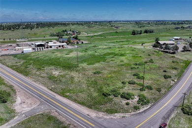
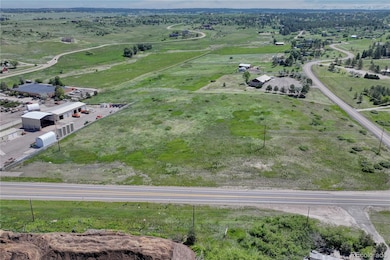
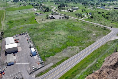
About This Lot
Unique 7.5-Acre corner lot on S Parker Rd (Hwy 83) & E Park Dr – Prime Location Just North of Franktown! Exceptional opportunity to own a high-visibility, 7.5-acre parcel at the corner of S Parker Rd (Highway 83) and E Park Dr. With excellent road frontage and exposure along a major thoroughfare, this property is ideally positioned in the path of future growth, just minutes from Franktown. Zoned ER (Estatel Residential) per Douglas County, the land supports a variety of uses—including residential, select community amenities such as churches and schools, and some care-based services like in-home daycare or elder care. Potential for special-use approval may include larger churches, veterinary hospitals, and even private sports or recreational facilities. Buyers are advised to verify all intended uses directly with Douglas County Planning. Whether you're looking to build now or invest for future development, this parcel offers flexibility, visibility, and long-term upside. Bring your vision—future development is coming!
Listing Agent
Realty One Group Elevations, LLC Brokerage Email: krodelteam@gmail.com,720-326-7177 License #100040896 Listed on: 06/11/2025

Property Details
Property Type
- Land
Est. Annual Taxes
- $10,770
Lot Details
- 7.5 Acre Lot
- Corner Lot
- Sloped Lot
- Property is zoned RR
Community Details
- No Home Owners Association
- Franktown Subdivision
Listing and Financial Details
- Property held in a trust
- Assessor Parcel Number R0049189
Map
Home Values in the Area
Average Home Value in this Area
Tax History
| Year | Tax Paid | Tax Assessment Tax Assessment Total Assessment is a certain percentage of the fair market value that is determined by local assessors to be the total taxable value of land and additions on the property. | Land | Improvement |
|---|---|---|---|---|
| 2024 | $10,770 | $124,970 | $124,970 | -- |
| 2023 | $10,891 | $124,970 | $124,970 | $0 |
| 2022 | $7,388 | $88,240 | $88,240 | $0 |
| 2021 | $7,442 | $88,240 | $88,240 | $0 |
| 2020 | $5,440 | $64,160 | $64,160 | $0 |
| 2019 | $5,466 | $64,160 | $64,160 | $0 |
| 2018 | $4,217 | $48,630 | $48,630 | $0 |
| 2017 | $3,927 | $48,630 | $48,630 | $0 |
| 2016 | $4,567 | $55,460 | $55,460 | $0 |
| 2015 | $4,671 | $55,460 | $55,460 | $0 |
| 2014 | $1,307 | $29,000 | $29,000 | $0 |
Property History
| Date | Event | Price | List to Sale | Price per Sq Ft |
|---|---|---|---|---|
| 06/11/2025 06/11/25 | For Sale | $750,000 | -- | -- |
Purchase History
| Date | Type | Sale Price | Title Company |
|---|---|---|---|
| Quit Claim Deed | $180,000 | None Listed On Document | |
| Warranty Deed | $194,850 | Fidelity National Title | |
| Interfamily Deed Transfer | -- | Fidelity National Title | |
| Interfamily Deed Transfer | -- | None Available | |
| Warranty Deed | $14,000 | -- |
Source: REcolorado®
MLS Number: 5867129
APN: 2349-340-00-002
Disclaimer: Certain information contained herein is derived from information provided by parties other than Homes.com. All information provided is deemed reliable, but is not guaranteed to be accurate and should be independently verified.
![]() The content relating to real estate for sale in this Web site comes in part from the Internet Data eXchange (“IDX”) program of METROLIST, INC., DBA RECOLORADO®. Real estate listings held by brokers other than Ten-X are marked with the IDX Logo. This information is being provided for the consumers’ personal, non-commercial use and may not be used for any other purpose. All information subject to change and should be independently verified.
The content relating to real estate for sale in this Web site comes in part from the Internet Data eXchange (“IDX”) program of METROLIST, INC., DBA RECOLORADO®. Real estate listings held by brokers other than Ten-X are marked with the IDX Logo. This information is being provided for the consumers’ personal, non-commercial use and may not be used for any other purpose. All information subject to change and should be independently verified.
This publication is designed to provide information with regard to the subject matter covered. It is displayed with the understanding that the publisher and authors are not engaged in rendering real estate, legal, accounting, tax, or other professional services and that the publisher and authors are not offering such advice in this publication. If real estate, legal, or other expert assistance is required, the services of a competent, professional person should be sought.
The information contained in this publication is subject to change without notice. METROLIST, INC., DBA RECOLORADO MAKES NO WARRANTY OF ANY KIND WITH REGARD TO THIS MATERIAL, INCLUDING, BUT NOT LIMITED TO, THE IMPLIED WARRANTIES OF MERCHANTABILITY AND FITNESS FOR A PARTICULAR PURPOSE. METROLIST, INC., DBA RECOLORADO SHALL NOT BE LIABLE FOR ERRORS CONTAINED HEREIN OR FOR ANY DAMAGES IN CONNECTION WITH THE FURNISHING, PERFORMANCE, OR USE OF THIS MATERIAL.
PUBLISHER’S NOTICE: All real estate advertised herein is subject to the Federal Fair Housing Act and the Colorado Fair Housing Act, which Acts make it illegal to make or publish any advertisement that indicates any preference, limitation, or discrimination based on race, color, religion, sex, handicap, familial status, or national origin.
METROLIST, INC., DBA RECOLORADO will not knowingly accept any advertising for real estate that is in violation of the law. All persons are hereby informed that all dwellings advertised are available on an equal opportunity basis.
© 2025 METROLIST, INC., DBA RECOLORADO® – All Rights Reserved. 6455 S. Yosemite St., Suite 500 Greenwood Village, CO 80111 USA
ALL RIGHTS RESERVED WORLDWIDE. No part of this publication may be reproduced, adapted, translated, stored in a retrieval system or transmitted in any form or by any means, electronic, mechanical, photocopying, recording, or otherwise, without the prior written permission of the publisher. The information contained herein including but not limited to all text, photographs, digital images, virtual tours, may be seeded and monitored for protection and tracking.
- 7417 Rafter Rd
- 7572 Kelty Trail
- 2685 Lost Lake Trail
- 7645 Fox Creek Trail
- 7497 Fox Creek Trail
- 5525 E State Highway 86
- 7924 Sabino Ln
- 8172 El Jebel Loop
- 7383 Bandit Dr
- 7496 Grady Cir
- 6555 San Miguel Ct
- 7258 Oasis Dr
- 7937 Grady Cir
- 7814 Grady Cir
- 7170 Oasis Dr
- 7799 Grady Cir
- 8980 Red Primrose St
- 7316 Meadow View
- 6078 Bridle Path Ln
- 6150 Solano Place
- 1671 N State Highway 83 Unit B
- 7682 Sabino Ln
- 5407 Rhyolite Way
- 6357 Old Divide Trail
- 8389 Owl Roost Ct
- 148 Vista Canyon Dr
- 5620 E Prescott Ave
- 4831 Basalt Ridge Cir
- 5358 E Spruce Ave
- 4393 E Andover Ave
- 3360 Esker Cir
- 3898 Red Valley Cir
- 11218 Ponderosa Ln
- 445 S Larkspur Dr
- 13725 Daffodil Point
- 1129 S Eaton Cir
- 10503 E Meadow Run
- 410 Black Feather Loop
- 2080 Oakcrest Cir
- 483 Scott Blvd