

297 N State Route 560 Urbana, OH 43078
Estimated payment $17,457/month
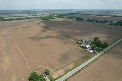
Highlights
- Barn
- 199.11 Acre Lot
- Shed
- Kolda Elementary School Rated A-
- No HOA
About This Lot
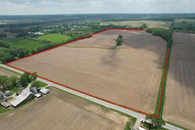
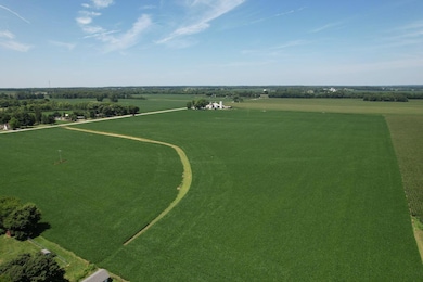
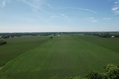
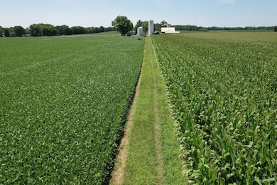
Amazing opportunity to purchase 199.106 acres of highly desirable farm ground. Approximately 182 acres tillable. Easy to maneuver large farm equipment, flat topography, & drains well with known gravel base in the region. Soil types consist of FNA-FOX SIL 0-2 S, LP-LIPPINCOTT SICL 0-2 S, FNB-FOX SIL 2-6 S, GN-GENESEE SIL 0-2 S., FNA-FOX SIL 0-2 S, MLC2-MIAMI SIL 6-12 M, CNB-CELINA SIL 2-6 S, MLB-MIAMI SIL 2-6 S. Land is deeded to a farm conservation easement and can only be used for agricultural purposes. Parcels #G22-07-11-11-00-002-00, #G22-07-11-11-00-003-00, #G21-07-11-17-00-047-00 to convey. Priced at $16,250 per acre.
Listing Agent
Bell Hankins Realty Group, LLC License #000445871 Listed on: 10/29/2025
Property Details
Property Type
- Land
Est. Annual Taxes
- $4,448
Lot Details
- 199.11 Acre Lot
- Zoning described as Agricultural
Farming
- Barn
Utilities
- Well
- Septic Tank
Listing and Financial Details
- Assessor Parcel Number G2207111100002000
Community Details
Overview
- No Home Owners Association
Recreation
- Shed
Map
Home Values in the Area
Average Home Value in this Area
Tax History
| Year | Tax Paid | Tax Assessment Tax Assessment Total Assessment is a certain percentage of the fair market value that is determined by local assessors to be the total taxable value of land and additions on the property. | Land | Improvement |
|---|---|---|---|---|
| 2024 | $3,280 | $366,480 | $326,740 | $39,740 |
| 2023 | $3,280 | $366,480 | $326,740 | $39,740 |
| 2022 | $3,292 | $366,480 | $326,740 | $39,740 |
| 2021 | $2,853 | $294,500 | $261,390 | $33,110 |
| 2020 | $2,810 | $294,500 | $261,390 | $33,110 |
| 2019 | $2,817 | $294,500 | $261,390 | $33,110 |
| 2018 | $3,337 | $201,020 | $179,190 | $21,830 |
| 2017 | $3,356 | $201,020 | $179,190 | $21,830 |
| 2016 | $3,333 | $201,020 | $179,190 | $21,830 |
| 2015 | $3,247 | $184,490 | $163,480 | $21,010 |
| 2014 | $3,301 | $185,030 | $163,480 | $21,550 |
| 2013 | $3,305 | $185,030 | $163,480 | $21,550 |
Property History
| Date | Event | Price | List to Sale | Price per Sq Ft |
|---|---|---|---|---|
| 10/29/2025 10/29/25 | For Sale | $3,235,472 | -- | -- |
Purchase History
| Date | Type | Sale Price | Title Company |
|---|---|---|---|
| Fiduciary Deed | -- | None Listed On Document | |
| Fiduciary Deed | -- | None Listed On Document |
Source: Western Regional Information Systems & Technology (WRIST)
MLS Number: 1042270
APN: G22-07-11-11-00-002-00
Disclaimer: Certain information contained herein is derived from information provided by parties other than Homes.com. All information provided is deemed reliable, but is not guaranteed to be accurate and should be independently verified.
![]() IDX information is provided exclusively for personal, non-commercial use, and may not be used for any purpose other than to identify prospective properties consumers may be interested in purchasing.
IDX information is provided exclusively for personal, non-commercial use, and may not be used for any purpose other than to identify prospective properties consumers may be interested in purchasing.
- 297 State Rte 560
- 0 Stickley Rd
- 000 Stickley Rd
- 5230 W US Highway 36
- 81 Country Rd
- 0 Barger Rd
- 00 Barger Rd
- 0 Old Troy Pike
- . Old Troy Pike
- 6744 Runkle Rd
- 3074 S State Route 560
- 0 Old Troy Pike Unit Lot 3 1030490
- 0 Old Troy Pike Unit Lot 3 919119
- 0 Old Troy Pike Unit Lot 3 224006744
- 1123 Miami St
- 00 Millerstown Rd
- 814 Gwynne St
- 403 Railroad St Unit 403
- 225 Railroad St Unit D
- 37 Monument Square Unit I
- 37 Monument Square Unit c
- 215 N Main St Unit 215H
- 215 N Main St Unit 215A
- 233 Scioto St Unit B
- 4887 Ridgewood Rd E
- 4725 Security Dr
- 3950 Cabot Dr
- 715 Villa Rd
- 1347 Villa Rd
- 2310 N Limestone St
- 1540 Faux Satin Dr
- 1835 E Home Rd
- 700 E McCreight Ave
- 1129.5 Garfield Ave
- 11000 Marquart Rd
- 44 W High St Unit B
