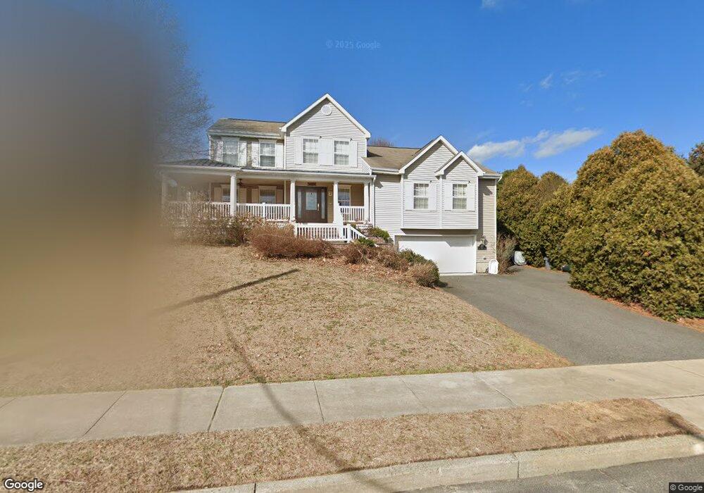
297 Old Bridge Rd Brielle, NJ 08730
Estimated Value: $1,226,842 - $1,485,000
4
Beds
2
Baths
2,554
Sq Ft
$527/Sq Ft
Est. Value
About This Home
This home is located at 297 Old Bridge Rd, Brielle, NJ 08730 and is currently estimated at $1,344,711, approximately $526 per square foot. 297 Old Bridge Rd is a home located in Monmouth County with nearby schools including Brielle Elementary School and The Brookside School.
Ownership History
Date
Name
Owned For
Owner Type
Purchase Details
Closed on
Aug 5, 2009
Sold by
Odonnell John E and Odonnell Sandra T
Bought by
Conrey James F and Conrey Henrietta Michele
Current Estimated Value
Home Financials for this Owner
Home Financials are based on the most recent Mortgage that was taken out on this home.
Original Mortgage
$350,000
Outstanding Balance
$231,209
Interest Rate
5.47%
Mortgage Type
Purchase Money Mortgage
Estimated Equity
$1,113,502
Purchase Details
Closed on
May 29, 1997
Sold by
Mayer Robert
Bought by
O'Donnell John
Home Financials for this Owner
Home Financials are based on the most recent Mortgage that was taken out on this home.
Original Mortgage
$240,000
Interest Rate
7.87%
Purchase Details
Closed on
Oct 16, 1995
Sold by
Scotia Construction Inc
Bought by
Mayer Robert and Mayer Joan
Create a Home Valuation Report for This Property
The Home Valuation Report is an in-depth analysis detailing your home's value as well as a comparison with similar homes in the area
Home Values in the Area
Average Home Value in this Area
Purchase History
| Date | Buyer | Sale Price | Title Company |
|---|---|---|---|
| Conrey James F | $670,000 | Stewart Title Guaranty Co | |
| O'Donnell John | $300,000 | -- | |
| Mayer Robert | $85,000 | -- |
Source: Public Records
Mortgage History
| Date | Status | Borrower | Loan Amount |
|---|---|---|---|
| Open | Conrey James F | $350,000 | |
| Previous Owner | O'Donnell John | $240,000 |
Source: Public Records
Tax History Compared to Growth
Tax History
| Year | Tax Paid | Tax Assessment Tax Assessment Total Assessment is a certain percentage of the fair market value that is determined by local assessors to be the total taxable value of land and additions on the property. | Land | Improvement |
|---|---|---|---|---|
| 2025 | $10,958 | $1,043,800 | $556,900 | $486,900 |
| 2024 | $11,395 | $883,000 | $405,000 | $478,000 |
| 2023 | $11,395 | $886,800 | $379,700 | $507,100 |
| 2022 | $9,616 | $795,500 | $329,100 | $466,400 |
| 2021 | $9,616 | $689,400 | $303,800 | $385,600 |
| 2020 | $10,480 | $640,200 | $263,300 | $376,900 |
| 2019 | $10,126 | $627,800 | $253,100 | $374,700 |
| 2018 | $10,057 | $615,500 | $258,200 | $357,300 |
| 2017 | $9,861 | $596,200 | $245,500 | $350,700 |
| 2016 | $9,738 | $589,800 | $237,900 | $351,900 |
| 2015 | $9,025 | $542,700 | $202,500 | $340,200 |
| 2014 | $10,568 | $678,300 | $453,800 | $224,500 |
Source: Public Records
Map
Nearby Homes
- 14 Lebanon Dr
- 308 South St
- 203 Lenape Trail
- 633 Agnes Ave
- 1207 Bayberry Rd
- 619 Park Ave
- 1210 Bayberry Rd
- 10 Acpoan Place
- 610 Agnes Ave
- 300 Union Ave
- 542 Woodland Ave
- 34 Gertrude Place
- 130 Union Ave
- 1307 W Union Ln Unit A4
- 2404 Lenape Trail
- 507 Magnolia Ave
- 508 Harris Ave
- 323-325 Fisk Ave
- 642 Rankin Rd
- 5 Hickory Ct Unit B