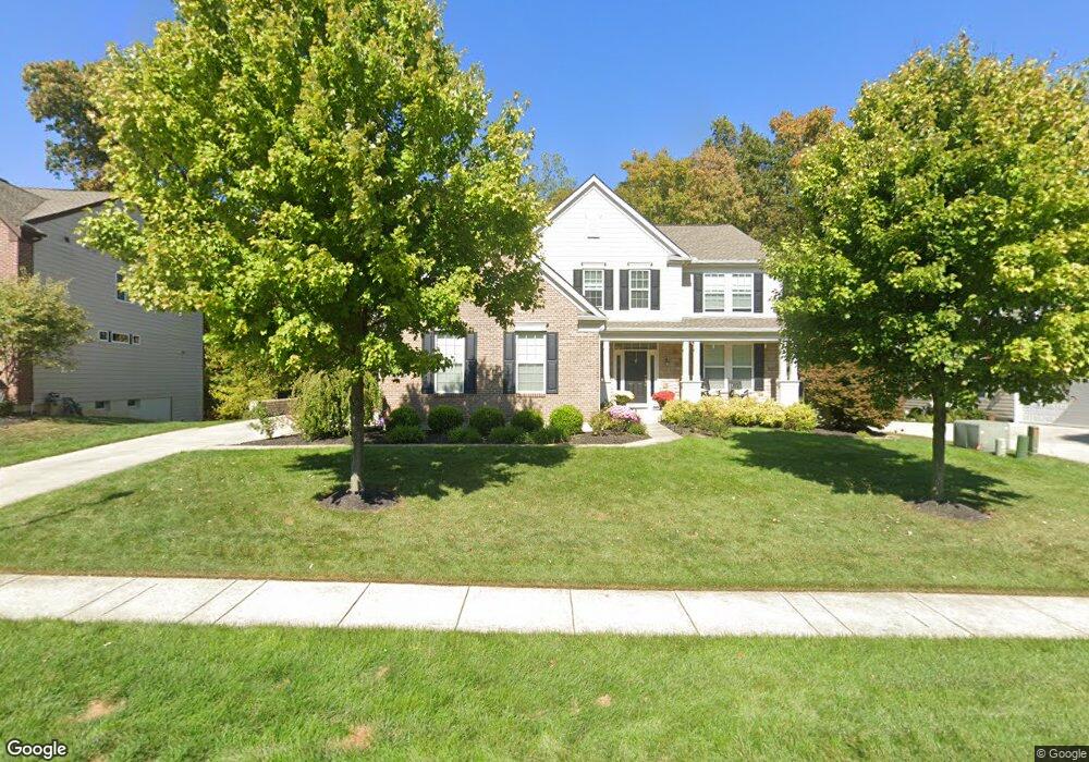
2971 Pleasant Colony Dr Lewis Center, OH 43035
Orange NeighborhoodEstimated Value: $619,000 - $715,000
4
Beds
4
Baths
3,197
Sq Ft
$209/Sq Ft
Est. Value
About This Home
This home is located at 2971 Pleasant Colony Dr, Lewis Center, OH 43035 and is currently estimated at $669,137, approximately $209 per square foot. 2971 Pleasant Colony Dr is a home located in Delaware County with nearby schools including Freedom Trail Elementary School, Olentangy Orange Middle School, and Orange High School.
Ownership History
Date
Name
Owned For
Owner Type
Purchase Details
Closed on
Feb 5, 2015
Sold by
Pertasko Aaron
Bought by
Petrasko Aaron J and Petrasko Courtney B
Current Estimated Value
Home Financials for this Owner
Home Financials are based on the most recent Mortgage that was taken out on this home.
Original Mortgage
$339,500
Outstanding Balance
$260,893
Interest Rate
3.85%
Mortgage Type
New Conventional
Estimated Equity
$408,244
Purchase Details
Closed on
Jul 17, 2009
Sold by
Fischer Single Family Homes Ii Llc
Bought by
Petrasko Aaron
Home Financials for this Owner
Home Financials are based on the most recent Mortgage that was taken out on this home.
Original Mortgage
$347,221
Interest Rate
5.43%
Mortgage Type
FHA
Purchase Details
Closed on
Jan 7, 2008
Sold by
Centex Homes
Bought by
Fischer Single Family Homes Ii Llc
Create a Home Valuation Report for This Property
The Home Valuation Report is an in-depth analysis detailing your home's value as well as a comparison with similar homes in the area
Home Values in the Area
Average Home Value in this Area
Purchase History
| Date | Buyer | Sale Price | Title Company |
|---|---|---|---|
| Petrasko Aaron J | -- | Landsel Title Agency | |
| Petrasko Aaron | $363,700 | Homestead Title | |
| Fischer Single Family Homes Ii Llc | $482,800 | Talon Group |
Source: Public Records
Mortgage History
| Date | Status | Borrower | Loan Amount |
|---|---|---|---|
| Open | Petrasko Aaron J | $339,500 | |
| Closed | Petrasko Aaron | $347,221 |
Source: Public Records
Tax History Compared to Growth
Tax History
| Year | Tax Paid | Tax Assessment Tax Assessment Total Assessment is a certain percentage of the fair market value that is determined by local assessors to be the total taxable value of land and additions on the property. | Land | Improvement |
|---|---|---|---|---|
| 2024 | $11,574 | $208,180 | $34,300 | $173,880 |
| 2023 | $11,616 | $208,180 | $34,300 | $173,880 |
| 2022 | $10,112 | $147,210 | $24,150 | $123,060 |
| 2021 | $10,168 | $147,210 | $24,150 | $123,060 |
| 2020 | $10,216 | $147,210 | $24,150 | $123,060 |
| 2019 | $8,772 | $130,870 | $21,000 | $109,870 |
| 2018 | $8,812 | $130,870 | $21,000 | $109,870 |
| 2017 | $8,699 | $119,840 | $18,620 | $101,220 |
| 2016 | $8,574 | $119,840 | $18,620 | $101,220 |
| 2015 | $7,761 | $118,800 | $18,660 | $100,140 |
| 2014 | $7,871 | $118,800 | $18,660 | $100,140 |
| 2013 | $7,670 | $113,130 | $18,660 | $94,470 |
Source: Public Records
Map
Nearby Homes
- 7631 Pleasant Colony Ct
- 2715 Tucker Trail
- 2383 Bold Venture Dr
- 3679 Birkland Cir
- 2216 Reeves Ave
- 2165 Ben Brush Place
- 3313 Glen Oaks Ct
- 1627 Bristol Commons Place
- 3138 E Powell Rd
- 3902 Rivers Run Dr
- 1923 Myrtle St
- 1746 E Powell Rd
- 1955 Royal Oak Dr
- 0 E Orange Rd Unit lot 1
- 0 E Orange Rd
- 7633 Storrington Place
- 6964 Saint Ninians St
- 2347 Jaxton Ct
- 7697 Bale Kenyon Rd
- 3670 E Powell Rd
- 2955 Pleasant Colony Dr
- 2989 Pleasant Colony Dr
- 2989 Pleasant Colony Dr Unit 255
- 3007 Pleasant Colony Dr Unit 256
- 3007 Pleasant Colony Dr
- 2939 Pleasant Colony Dr
- 2966 Pleasant Colony Dr
- 2988 Pleasant Colony Dr
- 2944 Pleasant Colony Dr
- 3027 Pleasant Colony Dr
- 2923 Pleasant Colony Dr
- 3008 Pleasant Colony Dr
- 2922 Pleasant Colony Dr
- 3028 Pleasant Colony Dr
- 3045 Pleasant Colony Dr
- 3045 Pleasant Colony Dr Unit 7258
- 2909 Pleasant Colony Dr
- 2894 Pleasant Colony Dr
- 3046 Pleasant Colony Dr
- 2895 Pleasant Colony Dr