Estimated Value: $616,000 - $921,004
--
Bed
--
Bath
2,854
Sq Ft
$271/Sq Ft
Est. Value
About This Home
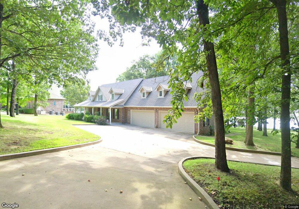
This home is located at 29770 S 587 Rd, Grove, OK 74344 and is currently estimated at $772,751, approximately $270 per square foot. 29770 S 587 Rd is a home with nearby schools including Grove Lower Elementary School, Grove Upper Elementary School, and Grove Middle School.
Ownership History
Date
Name
Owned For
Owner Type
Purchase Details
Closed on
Apr 30, 2024
Sold by
Collins Larry
Bought by
Collins 2023 Management Trust and Collins
Current Estimated Value
Purchase Details
Closed on
Dec 31, 2012
Sold by
Collins Larry and Collins John E
Bought by
Collins Larry
Purchase Details
Closed on
Dec 29, 2006
Sold by
Collins Larry
Bought by
Collins Larry and Collins John E
Purchase Details
Closed on
Oct 6, 2005
Sold by
Cmc Properties Llc
Bought by
Collins Larry
Create a Home Valuation Report for This Property
The Home Valuation Report is an in-depth analysis detailing your home's value as well as a comparison with similar homes in the area
Home Values in the Area
Average Home Value in this Area
Purchase History
| Date | Buyer | Sale Price | Title Company |
|---|---|---|---|
| Collins 2023 Management Trust | -- | None Listed On Document | |
| Collins Larry | -- | None Available | |
| Collins Larry | -- | -- | |
| Collins Larry | $190,000 | -- |
Source: Public Records
Tax History Compared to Growth
Tax History
| Year | Tax Paid | Tax Assessment Tax Assessment Total Assessment is a certain percentage of the fair market value that is determined by local assessors to be the total taxable value of land and additions on the property. | Land | Improvement |
|---|---|---|---|---|
| 2025 | $5,446 | $70,617 | $23,086 | $47,531 |
| 2024 | $5,446 | $67,254 | $22,679 | $44,575 |
| 2023 | $5,446 | $64,052 | $22,439 | $41,613 |
| 2022 | $5,094 | $61,360 | $22,368 | $38,992 |
| 2021 | $4,840 | $58,265 | $22,368 | $35,897 |
| 2020 | $4,688 | $55,331 | $22,368 | $32,963 |
| 2019 | $4,726 | $55,584 | $22,368 | $33,216 |
| 2018 | $4,631 | $54,578 | $22,368 | $32,210 |
| 2017 | $4,462 | $54,919 | $22,368 | $32,551 |
| 2016 | $4,247 | $52,324 | $22,368 | $29,956 |
| 2015 | $4,103 | $47,531 | $20,413 | $27,118 |
| 2014 | $4,123 | $47,531 | $20,413 | $27,118 |
Source: Public Records
Map
Nearby Homes
- 29641 S 586 Ln
- 58551 E 296 Place
- 29524 S 585 Ct
- TBD S 592 Place
- TBD S 585 Ct
- 6026 Lake Breeze Rd
- 402 Fairway Cir
- 29901 S 595 Rd
- 4926 Lost Cove Rd
- 4451 W 20th Rd
- 5070 Lake Breeze Rd
- 4949 Lost Cove Rd
- 4943 Lighthouse Springs Dr
- 5020 Lake Breeze Rd
- 5041 Lake Breeze Rd
- 1029 Village Dr
- 1515 St Joseph Dr
- 0 E 304 Rd Unit 25-955
- 0 E 304 Rd Unit 2518957
- 56901 E Walnut Dr