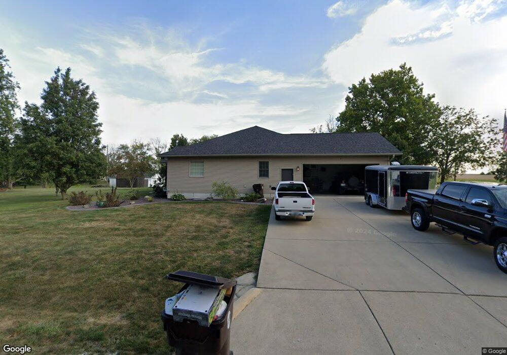
2980 Forest Crest Rd Decatur, IL 62521
Southside NeighborhoodEstimated Value: $225,000 - $424,000
Studio
--
Bath
2,135
Sq Ft
$147/Sq Ft
Est. Value
About This Home
This home is located at 2980 Forest Crest Rd, Decatur, IL 62521 and is currently estimated at $313,464, approximately $146 per square foot. 2980 Forest Crest Rd is a home located in Macon County with nearby schools including South Shores Elementary School, Stephen Decatur Middle School, and Maranatha Christian Academy.
Ownership History
Date
Name
Owned For
Owner Type
Purchase Details
Closed on
May 22, 2008
Sold by
Beasley Edward E
Bought by
Hood Edward Scott and Hood Shelly Kay
Current Estimated Value
Home Financials for this Owner
Home Financials are based on the most recent Mortgage that was taken out on this home.
Original Mortgage
$34,028
Interest Rate
5.93%
Mortgage Type
FHA
Create a Home Valuation Report for This Property
The Home Valuation Report is an in-depth analysis detailing your home's value as well as a comparison with similar homes in the area
Home Values in the Area
Average Home Value in this Area
Purchase History
| Date | Buyer | Sale Price | Title Company |
|---|---|---|---|
| Hood Edward Scott | $35,000 | None Available |
Source: Public Records
Mortgage History
| Date | Status | Borrower | Loan Amount |
|---|---|---|---|
| Closed | Hood Edward Scott | $34,028 |
Source: Public Records
Tax History
| Year | Tax Paid | Tax Assessment Tax Assessment Total Assessment is a certain percentage of the fair market value that is determined by local assessors to be the total taxable value of land and additions on the property. | Land | Improvement |
|---|---|---|---|---|
| 2024 | $5,251 | $84,462 | $11,138 | $73,324 |
| 2023 | $4,531 | $71,736 | $11,138 | $60,598 |
| 2022 | $4,387 | $68,436 | $10,625 | $57,811 |
| 2021 | $4,226 | $65,106 | $10,108 | $54,998 |
| 2020 | $4,054 | $61,710 | $9,581 | $52,129 |
| 2019 | $4,054 | $61,710 | $9,581 | $52,129 |
| 2018 | $3,866 | $59,359 | $9,216 | $50,143 |
| 2017 | $3,784 | $58,806 | $9,130 | $49,676 |
| 2016 | $3,810 | $58,683 | $9,111 | $49,572 |
| 2015 | $3,647 | $56,974 | $8,846 | $48,128 |
| 2014 | $3,435 | $56,409 | $8,758 | $47,651 |
| 2013 | $3,527 | $56,409 | $8,758 | $47,651 |
Source: Public Records
Map
Nearby Homes
- 53 Southside Country Club
- 3028 Olympia Dr
- 2529 W Alice Ln
- 15 Calumet Rd
- 1433 W Masters Ln
- 1450 Masters Ln
- 2705 S Taylor Rd
- 1412 W Grove Rd
- 2207 Forest Crest Dr
- 2505 W Saint Louis Bridge Rd
- 0 N Woodcock St
- 00 N Woodcock St
- 2065 W Rock Springs Rd
- 1316 W Sesom Dr
- 4845 S Taylor Rd
- 1740 S Fairview Ave
- 4952 S Taylor Rd
- 4220 S Lake Ct
- 51 Medial Dr
- 46 Medial Dr
- 2990 Forest Crest Rd
- 2960 Forest Crest Rd
- 3020 Forest Crest Rd
- 2552 Midiron Dr
- 2523 Fairway Ct
- 2542 Midiron Dr
- 2940 Forest Crest Rd
- 2522 Midiron Dr
- 2506 Fairway Ct
- 2506 Fairway Ct
- 2507 Fairway Ct
- 2516 Midiron Dr
- 2502 Midiron Dr
- 2909 Forest Crest Rd
- 2909 Forest Crest Rd
- 2834 Forest Crest Rd
- 2802 Forest Crest Rd
- 2821 Forest Crest Rd
- 2771 Forest Crest Rd
- 2772 Forest Crest Rd