Estimated Value: $276,000 - $414,000
5
Beds
6
Baths
3,057
Sq Ft
$111/Sq Ft
Est. Value
About This Home
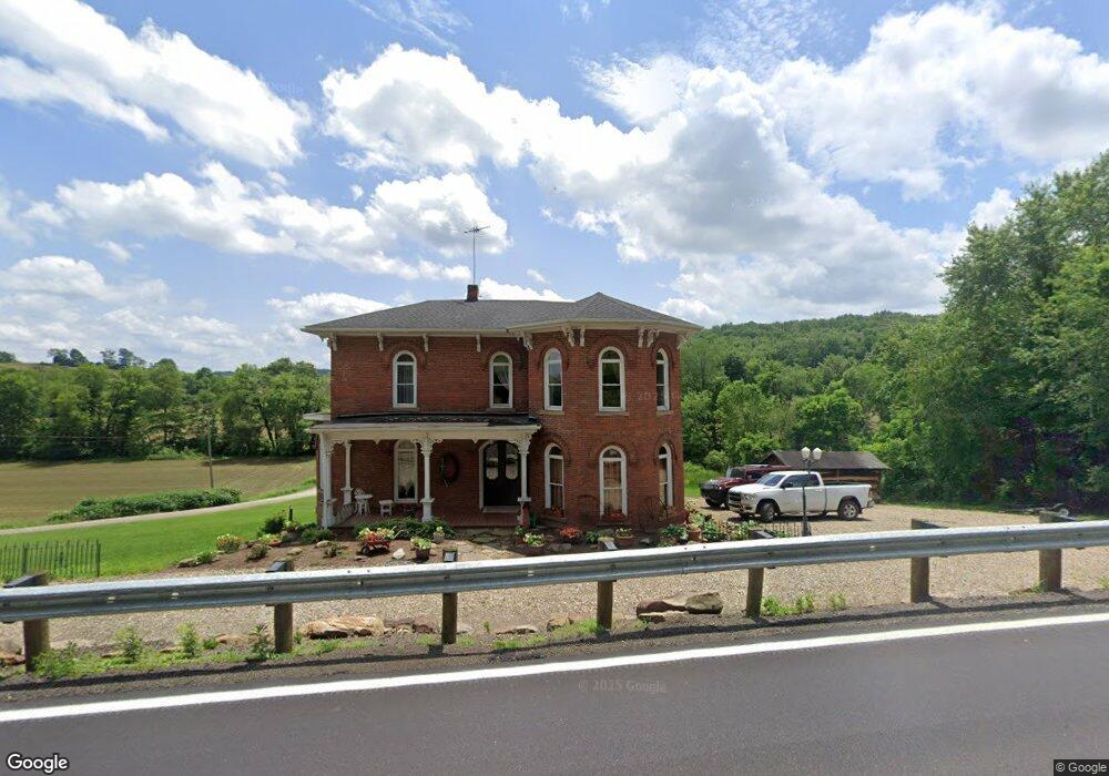
This home is located at 2982 State Route 516 NW, Dover, OH 44622 and is currently estimated at $339,442, approximately $111 per square foot. 2982 State Route 516 NW is a home located in Tuscarawas County with nearby schools including Dover High School.
Ownership History
Date
Name
Owned For
Owner Type
Purchase Details
Closed on
Jan 4, 2005
Sold by
Sigrist John L and Sigrist Linda S
Bought by
Cronebaugh Jeffrey H and Cronebaugh Jonna L
Current Estimated Value
Purchase Details
Closed on
Dec 28, 2004
Sold by
Sigrist John L and Sigrist Linda S
Bought by
Cronebaugh Jeffrey H and Cronebaugh Jonna L
Purchase Details
Closed on
Aug 10, 1992
Bought by
Hochstetler Mary and Sigrist Linda S
Purchase Details
Closed on
Nov 30, 1989
Sold by
Marino William P
Bought by
Beachy David R & 3 Others
Create a Home Valuation Report for This Property
The Home Valuation Report is an in-depth analysis detailing your home's value as well as a comparison with similar homes in the area
Home Values in the Area
Average Home Value in this Area
Purchase History
| Date | Buyer | Sale Price | Title Company |
|---|---|---|---|
| Cronebaugh Jeffrey H | $42,000 | -- | |
| Cronebaugh Jeffrey H | $42,000 | -- | |
| Hochstetler Mary | $31,000 | -- | |
| Beachy David R & 3 Others | $30,000 | -- |
Source: Public Records
Tax History Compared to Growth
Tax History
| Year | Tax Paid | Tax Assessment Tax Assessment Total Assessment is a certain percentage of the fair market value that is determined by local assessors to be the total taxable value of land and additions on the property. | Land | Improvement |
|---|---|---|---|---|
| 2024 | $2,618 | $62,920 | $14,690 | $48,230 |
| 2023 | $2,618 | $179,750 | $41,960 | $137,790 |
| 2022 | $2,646 | $62,913 | $14,686 | $48,227 |
| 2021 | $2,352 | $52,766 | $14,140 | $38,626 |
| 2020 | $2,470 | $52,766 | $14,140 | $38,626 |
| 2019 | $2,371 | $52,766 | $14,140 | $38,626 |
| 2018 | $2,105 | $44,530 | $11,930 | $32,600 |
| 2017 | $2,105 | $44,530 | $11,930 | $32,600 |
| 2016 | $2,103 | $44,530 | $11,930 | $32,600 |
| 2014 | $1,717 | $36,920 | $10,760 | $26,160 |
| 2013 | $1,719 | $36,920 | $10,760 | $26,160 |
Source: Public Records
Map
Nearby Homes
- 0 Bair Rd NW Unit 5124469
- 0 Bair Rd NW Unit 5124477
- 0 Bair Rd NW Unit 5124464
- 0 Bair Rd NW Unit 5124485
- 0 Bair Rd NW Unit 5124339
- 0 Bair Rd NW Unit 5124397
- 0 Bair Rd NW Unit 5124402
- 0 Bair Rd NW Unit 5124415
- 0 Bair Rd NW Unit 5124421
- 0 Swonger Rd Unit 5161456
- 0 Swonger Rd Unit 5161457
- 4029 Minard Rd NW
- 2180 Kimberley Dr NW
- 500 W 13th St
- 1411 Chestnut St
- 1319 N Walnut St
- 3030 N Wooster Ave
- 159 Charles Dr
- 306 E 15th St
- 0000 Red Hill Rd NW
- 3015 State Route 516 NW
- 2945 State Route 516 NW
- 2945 Ohio 516
- 2925 State Route 516 NW
- 3051 State Route 516 NW
- 2973 State Route 516 NW
- 2973 Ohio 516
- 3029 State Route 516 NW
- 2987 State Route 516 NW
- 3069 State Route 516 NW
- 2885 State Route 516 NW
- 2969 State Route 516 NW
- 2997 State Route 516 NW
- 3091 State Route 516 NW
- 3103 State Route 516 NW
- 2857 State Route 516 NW
- 3113 State Route 516 NW
- 3149 State Route 516 NW
- 2825 State Route 516 NW
- 3125 State Route 516 NW