
Seller's Agent in 2025
Kristine Baldwin
Skogman - Manchester
(563) 920-9194
123 Total Sales
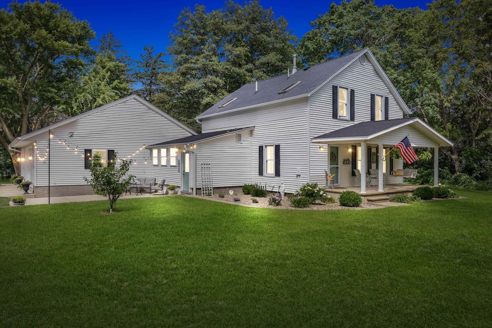


Spacious Acreage with the perfect updates along the way! Beautiful Home situated on 3 acres m/l! Spacious living with large eat-in kitchen Offering 3-bedrooms, 2-bath including a primary suite with 3⁄4 bath. This home will impress with ideal mix of comfort and country living. 3-car attached garage finished with a floor drain and in-floor heat ready to be hooked up. Additional usable outbuildings including a barn with new steel roof and fenced area for the chickens provides endless options. Enjoy the outdoors from the covered front porch with swing, patio, established fruit trees/bushes and garden beds. Located just a half mile off hard surface road.
| Date | Type | Sale Price | Title Company |
|---|---|---|---|
| Warranty Deed | $387,500 | None Listed On Document | |
| Warranty Deed | $164,000 | None Available |
| Date | Status | Loan Amount | Loan Type |
|---|---|---|---|
| Open | $368,125 | New Conventional |
| Date | Event | Price | List to Sale | Price per Sq Ft |
|---|---|---|---|---|
| 10/17/2025 10/17/25 | Sold | $387,500 | -2.9% | $210 / Sq Ft |
| 09/02/2025 09/02/25 | Pending | -- | -- | -- |
| 08/20/2025 08/20/25 | For Sale | $399,000 | -- | $216 / Sq Ft |
| Year | Tax Paid | Tax Assessment Tax Assessment Total Assessment is a certain percentage of the fair market value that is determined by local assessors to be the total taxable value of land and additions on the property. | Land | Improvement |
|---|---|---|---|---|
| 2025 | $2,308 | $238,900 | $64,000 | $174,900 |
| 2024 | $2,308 | $196,040 | $56,470 | $139,570 |
| 2023 | $2,238 | $196,040 | $56,470 | $139,570 |
| 2022 | $2,046 | $157,510 | $45,100 | $112,410 |
| 2021 | $2,064 | $157,510 | $45,100 | $112,410 |
| 2020 | $2,064 | $144,930 | $41,000 | $103,930 |
| 2019 | $2,106 | $144,930 | $41,000 | $103,930 |
| 2018 | $1,978 | $140,070 | $41,000 | $99,070 |
| 2017 | $1,954 | $140,070 | $41,000 | $99,070 |
| 2016 | $2,050 | $134,930 | $33,320 | $101,610 |
| 2015 | $2,050 | $134,930 | $33,320 | $101,610 |
| 2014 | $2,118 | $134,930 | $33,320 | $101,610 |
Seller's Agent in 2025
Kristine Baldwin
Skogman - Manchester
(563) 920-9194
123 Total Sales
J
Buyer's Agent in 2025
Joe Leiser
UNKNOWN OFFICE
(563) 556-5721
123 Total Sales
Source: East Central Iowa Association of REALTORS®
MLS Number: ECR152820
APN: 14.07.300.006
Disclaimer: Certain information contained herein is derived from information provided by parties other than Homes.com. All information provided is deemed reliable, but is not guaranteed to be accurate and should be independently verified.
![]() Based on information submitted to the MLS GRID. All data is obtained from various sources and may not have been verified by broker or MLS GRID. Supplied Open House Information is subject to change without notice. All information should be independently reviewed and verified for accuracy. Properties may or may not be listed by the office/agent presenting the information. Some IDX listings have been excluded from this website. IDX information is provided exclusively for personal, non-commercial use, and may not be used for any purpose other than to identify prospective properties consumers may be interested in purchasing. Information is deemed reliable but not guaranteed.
Based on information submitted to the MLS GRID. All data is obtained from various sources and may not have been verified by broker or MLS GRID. Supplied Open House Information is subject to change without notice. All information should be independently reviewed and verified for accuracy. Properties may or may not be listed by the office/agent presenting the information. Some IDX listings have been excluded from this website. IDX information is provided exclusively for personal, non-commercial use, and may not be used for any purpose other than to identify prospective properties consumers may be interested in purchasing. Information is deemed reliable but not guaranteed.
Based on information submitted to the MLS GRID
Ask me questions while you tour the home.