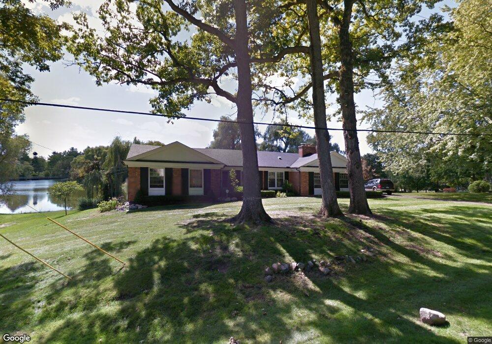
2985 Peterboro Rd West Bloomfield, MI 48323
Estimated Value: $541,170 - $672,000
5
Beds
4
Baths
2,390
Sq Ft
$242/Sq Ft
Est. Value
About This Home
This home is located at 2985 Peterboro Rd, West Bloomfield, MI 48323 and is currently estimated at $577,793, approximately $241 per square foot. 2985 Peterboro Rd is a home located in Oakland County with nearby schools including West Hills Middle School, Bloomfield Hills High School, and Brookfield Academy - West Bloomfield Campus.
Ownership History
Date
Name
Owned For
Owner Type
Purchase Details
Closed on
Jul 17, 2020
Sold by
Farris Vanessa and Harris Vanessa
Bought by
Farris Vanessa and Farris Kristian L
Current Estimated Value
Purchase Details
Closed on
Mar 6, 2012
Sold by
Farris Vanessa and Weaver Edna E
Bought by
Farris Vanessa and Weaver Edna E
Home Financials for this Owner
Home Financials are based on the most recent Mortgage that was taken out on this home.
Original Mortgage
$178,300
Outstanding Balance
$122,946
Interest Rate
3.95%
Mortgage Type
New Conventional
Estimated Equity
$454,847
Purchase Details
Closed on
Aug 11, 1995
Sold by
Cook Selby L
Bought by
Farris Vanessa and Weaver Edna E
Home Financials for this Owner
Home Financials are based on the most recent Mortgage that was taken out on this home.
Original Mortgage
$196,000
Interest Rate
7.64%
Mortgage Type
New Conventional
Create a Home Valuation Report for This Property
The Home Valuation Report is an in-depth analysis detailing your home's value as well as a comparison with similar homes in the area
Home Values in the Area
Average Home Value in this Area
Purchase History
| Date | Buyer | Sale Price | Title Company |
|---|---|---|---|
| Farris Vanessa | -- | None Available | |
| Farris Vanessa | -- | Rels Title | |
| Farris Vanessa | $245,000 | -- |
Source: Public Records
Mortgage History
| Date | Status | Borrower | Loan Amount |
|---|---|---|---|
| Open | Farris Vanessa | $178,300 | |
| Closed | Farris Vanessa | $196,000 |
Source: Public Records
Tax History Compared to Growth
Tax History
| Year | Tax Paid | Tax Assessment Tax Assessment Total Assessment is a certain percentage of the fair market value that is determined by local assessors to be the total taxable value of land and additions on the property. | Land | Improvement |
|---|---|---|---|---|
| 2024 | $3,173 | $239,390 | $0 | $0 |
| 2022 | $3,063 | $199,540 | $44,270 | $155,270 |
| 2021 | $6,008 | $190,470 | $0 | $0 |
| 2020 | $2,557 | $183,340 | $44,270 | $139,070 |
| 2018 | $5,859 | $168,660 | $35,470 | $133,190 |
| 2015 | -- | $148,740 | $0 | $0 |
| 2014 | -- | $133,700 | $0 | $0 |
| 2011 | -- | $116,760 | $0 | $0 |
Source: Public Records
Map
Nearby Homes
- 4274 Wendell Rd
- 0 Wendell Rd Unit 20250033815
- 2460 Turner St
- 3142 Bloomfield Shore Dr
- 3367 Lone Pine Rd
- 2943 Moon Lake Dr Unit 52
- 4641 Cove Rd
- 3075 Bloomfield Park Dr
- 0000 Middlebelt Rd
- 3440 Lone Pine Rd
- 4182 Prescott Park Cir
- 4174 Prescott Park Cir
- 4170 Prescott Park Cir
- 4670 Cove Rd
- 2433 Wickfield Rd
- 4710 Cove Rd
- 4568 Rolling Ridge Rd
- 4941 Fairway Ridge Cir
- 4033 Fox Lake Dr
- 3930 Maple Hill W
- 2961 Peterboro Rd
- 4206 Stoddard Rd
- 4235 Stoddard Rd
- 4188 Stoddard Rd
- 4189 Stoddard Rd
- 2933 Peterboro Rd Unit Bldg-Unit
- 2933 Peterboro Rd
- 4242 Wendell Rd
- 4253 Stoddard Rd
- 4177 Stoddard Rd
- 2912 Brentwood Rd
- 2915 Peterboro Rd
- 4180 Stoddard Rd
- 2901 Brentwood Rd
- 4271 Stoddard Rd
- 2915 Brentwood Rd
- 4260 Stoddard Rd
- 2929 Brentwood Rd
- 4165 Stoddard Rd
- 4289 Stoddard Rd