
Seller's Agent in 2026
Margaretann Fiderio
William Raveis Real Estate
(203) 901-3867
1 in this area
74 Total Sales
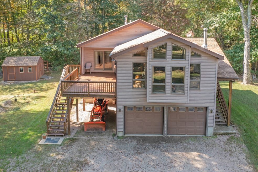
Contemporary Colonial Retreat on 4.71 Private Acres featuring 3 Bedrooms, plus a bonus recreation room & 2 Full Baths. Discover the perfect blend of contemporary design & colonial-inspired charm in this beautifully maintained one-owner home, privately nestled on 4.71 acres of level, wooded lot & backed by Audubon Conservatory property. Built in 1999 & meticulously cared for, this residence offers the ideal combination of modern comfort, timeless architectural style, & a serene nature-focused setting. Thoughtfully updated approx. 1,708 sq. ft. of bright, inviting living space with natural wood tones & warm gathering spaces are paired with modern features such as exposed beams, soaring cathedral ceilings, & dramatic two-story windows that fill the home with natural light. The main living areas are positioned on the upper floor & boast an open-concept layout that feels both spacious & welcoming. The sun-filled living room, dining area, & kitchen flow seamlessly together, enhanced by the ambiance of a cozy wood-burning stove & you can step directly from the kitchen or master bedroom onto the oversized mahogany deck; an exceptional space for outdoor dining, entertaining, or simply unwinding in the tranquility of nature. The vaulted ceilings & expansive windows create an airy atmosphere from every angle. The upper level also includes the spacious primary bedroom & 2nd bedroom, both with convenient access to a generous full bathroom with a shower & soaking tub.
Last Agent to Sell the Property
William Raveis Real Estate Brokerage Phone: (203) 901-3867 License #RES.0807559 Listed on: 12/08/2025
| Date | Type | Sale Price | Title Company |
|---|---|---|---|
| Warranty Deed | $530,000 | -- | |
| Warranty Deed | $33,000 | -- | |
| Warranty Deed | $33,000 | -- |
| Date | Status | Loan Amount | Loan Type |
|---|---|---|---|
| Previous Owner | $78,500 | No Value Available | |
| Previous Owner | $100,000 | No Value Available | |
| Previous Owner | $18,000 | No Value Available | |
| Previous Owner | $118,300 | No Value Available |
| Date | Event | Price | List to Sale | Price per Sq Ft |
|---|---|---|---|---|
| 01/13/2026 01/13/26 | Sold | $530,000 | 0.0% | $310 / Sq Ft |
| 12/12/2025 12/12/25 | For Sale | $530,000 | -- | $310 / Sq Ft |
| Year | Tax Paid | Tax Assessment Tax Assessment Total Assessment is a certain percentage of the fair market value that is determined by local assessors to be the total taxable value of land and additions on the property. | Land | Improvement |
|---|---|---|---|---|
| 2025 | $5,186 | $270,800 | $143,600 | $127,200 |
| 2024 | $4,964 | $270,800 | $143,600 | $127,200 |
| 2023 | $4,918 | $270,800 | $143,600 | $127,200 |
| 2022 | $5,224 | $213,300 | $117,800 | $95,500 |
| 2021 | $5,266 | $213,300 | $117,800 | $95,500 |
| 2020 | $5,155 | $213,300 | $117,800 | $95,500 |
| 2019 | $5,158 | $212,000 | $117,800 | $94,200 |
| 2018 | $4,984 | $212,000 | $117,800 | $94,200 |
| 2017 | $4,829 | $202,400 | $117,800 | $84,600 |
| 2016 | $4,667 | $202,400 | $117,800 | $84,600 |
| 2015 | $4,467 | $202,400 | $117,800 | $84,600 |
| 2014 | $4,287 | $202,400 | $117,800 | $84,600 |
Seller's Agent in 2026
Margaretann Fiderio
William Raveis Real Estate
(203) 901-3867
1 in this area
74 Total Sales
J
Buyer's Agent in 2026
Juliet McCabe
Compass Connecticut, LLC
(203) 245-1593
1 in this area
3 Total Sales
Source: SmartMLS
MLS Number: 24132555
APN: STON-000083-000003-000003I
Disclaimer: Certain information contained herein is derived from information provided by parties other than Homes.com. All information provided is deemed reliable, but is not guaranteed to be accurate and should be independently verified.
![]() IDX information is provided exclusively for personal, non-commercial use, and may not be used for any purpose other than to identify prospective properties consumers may be interested in purchasing. Information is deemed reliable but not guaranteed.
IDX information is provided exclusively for personal, non-commercial use, and may not be used for any purpose other than to identify prospective properties consumers may be interested in purchasing. Information is deemed reliable but not guaranteed.
Ask me questions while you tour the home.