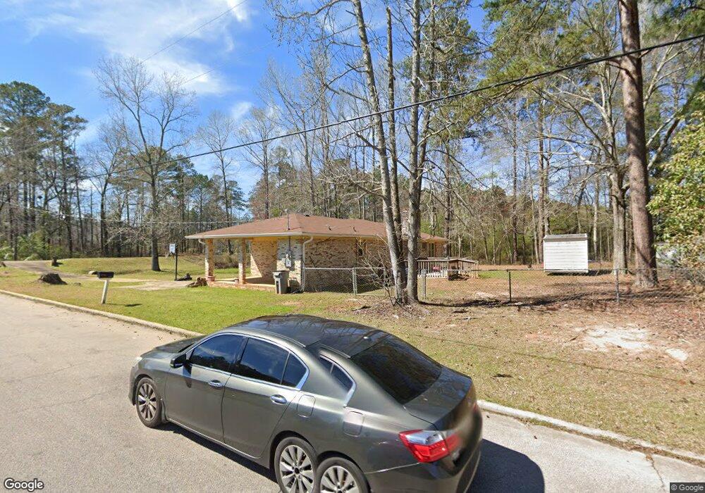
299 Ragland St Lagrange, GA 30241
Estimated Value: $163,571 - $197,000
3
Beds
2
Baths
1,351
Sq Ft
$134/Sq Ft
Est. Value
About This Home
This home is located at 299 Ragland St, Lagrange, GA 30241 and is currently estimated at $180,893, approximately $133 per square foot. 299 Ragland St is a home located in Troup County with nearby schools including Callaway Elementary School, Hogansville Elementary School, and Callaway Middle School.
Ownership History
Date
Name
Owned For
Owner Type
Purchase Details
Closed on
Oct 24, 1996
Sold by
Tucker Elaine
Bought by
Cameron Johnnie Lou
Current Estimated Value
Purchase Details
Closed on
Nov 1, 1987
Bought by
Tucker Elaine
Purchase Details
Closed on
Oct 24, 1979
Sold by
Elain Roger and Elain Tucker
Purchase Details
Closed on
Jun 15, 1976
Sold by
Landfieldan
Bought by
Elain Roger and Elain Tucker
Purchase Details
Closed on
Apr 19, 1974
Sold by
Landfieldan Corp
Bought by
Landfieldan
Create a Home Valuation Report for This Property
The Home Valuation Report is an in-depth analysis detailing your home's value as well as a comparison with similar homes in the area
Home Values in the Area
Average Home Value in this Area
Purchase History
| Date | Buyer | Sale Price | Title Company |
|---|---|---|---|
| Cameron Johnnie Lou | $50,600 | -- | |
| Tucker Elaine | -- | -- | |
| -- | -- | -- | |
| Elain Roger | -- | -- | |
| Landfieldan | -- | -- |
Source: Public Records
Tax History Compared to Growth
Tax History
| Year | Tax Paid | Tax Assessment Tax Assessment Total Assessment is a certain percentage of the fair market value that is determined by local assessors to be the total taxable value of land and additions on the property. | Land | Improvement |
|---|---|---|---|---|
| 2024 | $833 | $59,604 | $6,000 | $53,604 |
| 2023 | $161 | $43,860 | $6,000 | $37,860 |
| 2022 | $353 | $41,260 | $6,000 | $35,260 |
| 2021 | $300 | $36,452 | $7,400 | $29,052 |
| 2020 | $799 | $36,452 | $7,400 | $29,052 |
| 2019 | $704 | $33,312 | $7,400 | $25,912 |
| 2018 | $704 | $32,982 | $7,070 | $25,912 |
| 2017 | $694 | $32,982 | $7,070 | $25,912 |
| 2016 | $667 | $32,070 | $7,070 | $25,000 |
| 2015 | $678 | $32,409 | $7,409 | $25,000 |
| 2014 | $638 | $31,093 | $7,409 | $23,684 |
| 2013 | -- | $32,459 | $7,409 | $25,050 |
Source: Public Records
Map
Nearby Homes
- 215 Poplar Cir
- 1017 Mason St
- 957 Kelley St
- LOT 4 Borton St
- LOT 3 Borton St
- LOT 5 Borton St
- LOT 6 Borton St
- 0 Kelley St Unit 10550311
- 0 E Render St
- 913 Arizona St Unit A AND B
- 117 Belk St
- 113 Pine Cir
- LOT 58 Belk St
- 119 Belk St
- LOT 65 Belk St
- LOT 66 Belk St
- 15 Fulton St
- 75 Thomas Rd
- 311 Mourning Ct Unit LOT 33
- 313 Mourning Ct Unit LOT 32
- 101 Haley Way
- 301 Ragland St
- 300 Ragland St
- 303 Ragland St
- 103 Haley Way
- 102 Willowcreek Rd
- 305 Ragland St
- 302 Ragland St
- 101 Willowcreek Rd
- 319 Ragland St
- 307 Ragland St
- 304 Ragland St
- 109 Willowcreek Rd
- 109 Willowcreek Rd
- 0 Merrywood Dr Unit 1 7611245
- 0 Merrywood Dr Unit 2 7611224
- 0 Merrywood Dr Unit 3 7611183
- 0 Merrywood Dr Unit 8720836
- 0 Merrywood Dr Unit 8340265
- 0 Merrywood Dr Unit 8386379