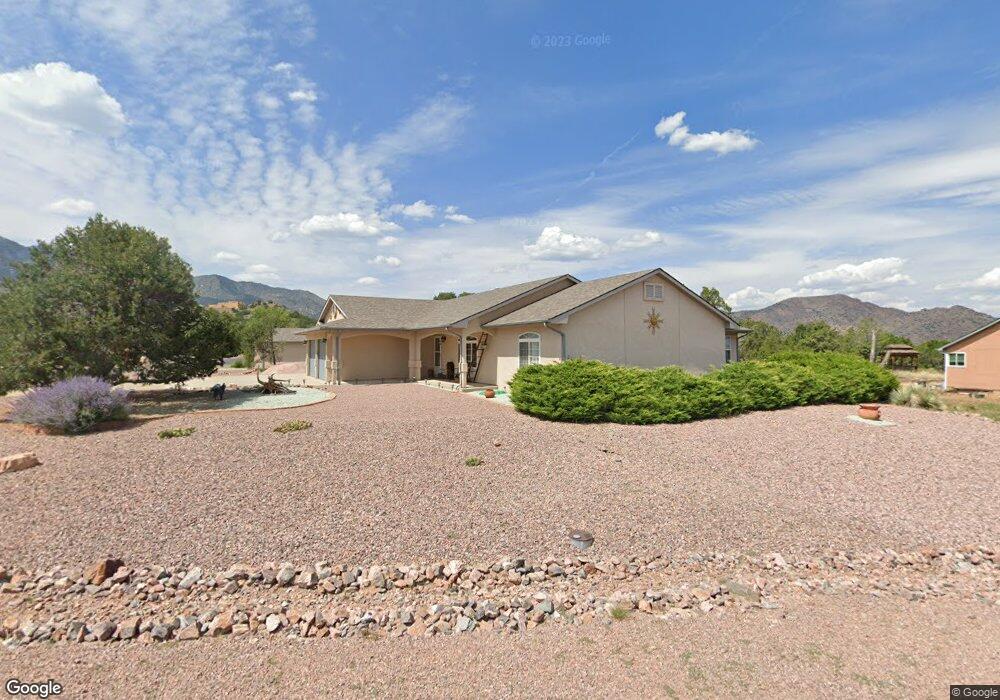
299 Savage Loop Cañon City, CO 81212
Estimated Value: $425,979 - $539,000
3
Beds
2
Baths
1,838
Sq Ft
$272/Sq Ft
Est. Value
About This Home
This home is located at 299 Savage Loop, Cañon City, CO 81212 and is currently estimated at $499,245, approximately $271 per square foot. 299 Savage Loop is a home located in Fremont County with nearby schools including Lincoln School of Science & Technology, Canon City Middle School, and Canon City High School.
Ownership History
Date
Name
Owned For
Owner Type
Purchase Details
Closed on
Jun 30, 2015
Sold by
Reed William Craig and Reed Dixie A
Bought by
Fisher Paul S and Fisher Susan M
Current Estimated Value
Home Financials for this Owner
Home Financials are based on the most recent Mortgage that was taken out on this home.
Original Mortgage
$190,000
Outstanding Balance
$73,713
Interest Rate
3.91%
Mortgage Type
New Conventional
Estimated Equity
$425,532
Purchase Details
Closed on
Jul 14, 1997
Sold by
Snyder D/B/A Snyder Construction
Bought by
Reed
Purchase Details
Closed on
Apr 1, 1997
Sold by
Tezak
Bought by
Tezak
Purchase Details
Closed on
Mar 31, 1997
Sold by
Tezak
Bought by
Snyder
Create a Home Valuation Report for This Property
The Home Valuation Report is an in-depth analysis detailing your home's value as well as a comparison with similar homes in the area
Home Values in the Area
Average Home Value in this Area
Purchase History
| Date | Buyer | Sale Price | Title Company |
|---|---|---|---|
| Fisher Paul S | $238,500 | Stewart Title | |
| Reed | $159,000 | -- | |
| Tezak | -- | -- | |
| Snyder | $35,000 | -- |
Source: Public Records
Mortgage History
| Date | Status | Borrower | Loan Amount |
|---|---|---|---|
| Open | Fisher Paul S | $190,000 |
Source: Public Records
Tax History Compared to Growth
Tax History
| Year | Tax Paid | Tax Assessment Tax Assessment Total Assessment is a certain percentage of the fair market value that is determined by local assessors to be the total taxable value of land and additions on the property. | Land | Improvement |
|---|---|---|---|---|
| 2024 | $2,022 | $26,509 | $0 | $0 |
| 2023 | $2,022 | $22,824 | $0 | $0 |
| 2022 | $2,005 | $23,105 | $0 | $0 |
| 2021 | $2,011 | $23,770 | $0 | $0 |
| 2020 | $1,672 | $19,907 | $0 | $0 |
| 2019 | $1,651 | $19,907 | $0 | $0 |
| 2018 | $1,468 | $17,257 | $0 | $0 |
| 2017 | $1,367 | $17,257 | $0 | $0 |
| 2016 | $1,254 | $17,140 | $0 | $0 |
| 2015 | $1,252 | $17,140 | $0 | $0 |
| 2012 | $1,241 | $17,815 | $3,980 | $13,835 |
Source: Public Records
Map
Nearby Homes
- 265 Pelage Ct
- 200 Wolf Cub Trail
- 206 Wolf Cub Trail
- 207 Savage Loop
- TBD Forge Rd
- 1751 Forge Rd
- 133 Blue Grouse Dr
- 159 Blue Grouse Dr
- 121 Mourning Dove Dr
- 29 Kyndra Ct
- 98 Wild Rose Dr
- TBD Wild Rose Dr
- 147 Mourning Dove Dr
- 123 Wild Rose Dr
- 28 Eagle Crest Dr
- 94 Eagle Dr S
- 58 Wild Rose Dr
- 105 Bobwhite Loop
- 418 Greenhorn Dr