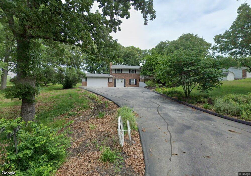
299 Shepard Ln Pacific, MO 63069
Estimated Value: $266,000 - $344,000
3
Beds
2
Baths
1,658
Sq Ft
$182/Sq Ft
Est. Value
About This Home
This home is located at 299 Shepard Ln, Pacific, MO 63069 and is currently estimated at $302,417, approximately $182 per square foot. 299 Shepard Ln is a home located in Franklin County with nearby schools including Pacific High School.
Ownership History
Date
Name
Owned For
Owner Type
Purchase Details
Closed on
Oct 7, 2025
Sold by
Weaver Christian A
Bought by
Christian A Weaver Trust
Current Estimated Value
Purchase Details
Closed on
Aug 12, 2024
Sold by
Michael G Weaver Living Trust
Bought by
Weaver Christian A
Home Financials for this Owner
Home Financials are based on the most recent Mortgage that was taken out on this home.
Original Mortgage
$150,000
Interest Rate
6.86%
Mortgage Type
New Conventional
Purchase Details
Closed on
Dec 3, 2020
Sold by
Weaver Trust
Bought by
Weaver Trust
Purchase Details
Closed on
Aug 15, 2005
Sold by
Weaver Dniel E
Bought by
Weaver Dniel E
Create a Home Valuation Report for This Property
The Home Valuation Report is an in-depth analysis detailing your home's value as well as a comparison with similar homes in the area
Home Values in the Area
Average Home Value in this Area
Purchase History
| Date | Buyer | Sale Price | Title Company |
|---|---|---|---|
| Christian A Weaver Trust | -- | None Listed On Document | |
| Weaver Christian A | -- | None Listed On Document | |
| Weaver Trust | -- | None Available | |
| Weaver Dniel E | -- | None Available |
Source: Public Records
Mortgage History
| Date | Status | Borrower | Loan Amount |
|---|---|---|---|
| Previous Owner | Weaver Christian A | $150,000 |
Source: Public Records
Tax History
| Year | Tax Paid | Tax Assessment Tax Assessment Total Assessment is a certain percentage of the fair market value that is determined by local assessors to be the total taxable value of land and additions on the property. | Land | Improvement |
|---|---|---|---|---|
| 2025 | $3,037 | $37,037 | $0 | $0 |
| 2024 | $2,775 | $33,552 | $0 | $0 |
| 2023 | $2,775 | $33,193 | $0 | $0 |
| 2022 | $2,311 | $30,045 | $0 | $0 |
| 2021 | $2,301 | $30,045 | $0 | $0 |
| 2020 | $2,105 | $27,119 | $0 | $0 |
| 2019 | $1,902 | $27,119 | $0 | $0 |
| 2018 | $1,886 | $26,355 | $0 | $0 |
| 2017 | $1,874 | $26,355 | $0 | $0 |
| 2016 | $1,840 | $25,591 | $0 | $0 |
| 2015 | $1,791 | $25,591 | $0 | $0 |
| 2014 | $1,783 | $25,870 | $0 | $0 |
Source: Public Records
Map
Nearby Homes
- 0 Venus Ln
- 3858 Ronnie Ln
- 1695 Wade Rd
- 3958 Highway Nn
- 403 Lakeview Dr
- 407 Lakeview Dr
- 0 Red Bud Unit MIS25053128
- 1414 Timber Valley Ct
- 3 Oak Hill Rd
- 0 Oak Hill Rd
- 0 N Lakeshore Dr
- S Denton Rd
- Lot36 BLOCKF Redbud Dr
- Lot 44-48 Redbud Dr
- 3956 & 3960 Redbud Dr
- 3830 Redwood Ln
- 3838 Oak Hill Dr
- 2557 Nike Base Rd
- 3846 Oak Hill Rd
- Lot 45 Block G Red Bud Dr
- 287 Shepard Ln
- 3611 Westwood Dr
- 245 Shepard Ln
- 298 Venus Ln
- 275 Shepard Ln
- 304 Venus Ln
- 271 Shepard Ln
- 277 Patton Dr
- 303 Venus Ln
- 3 38 Acres Venus Ln
- 3605 Twin Oaks Dr
- 3625 Westwood Dr
- 280 Patton Dr
- 315 Venus Ln
- 316 Venus Ln
- 3632 Westwood Dr
- 3641 Twin Oaks Dr
- 3637 Westwood Dr
- 329 Venus Ln
- 328 Venus Ln
Your Personal Tour Guide
Ask me questions while you tour the home.