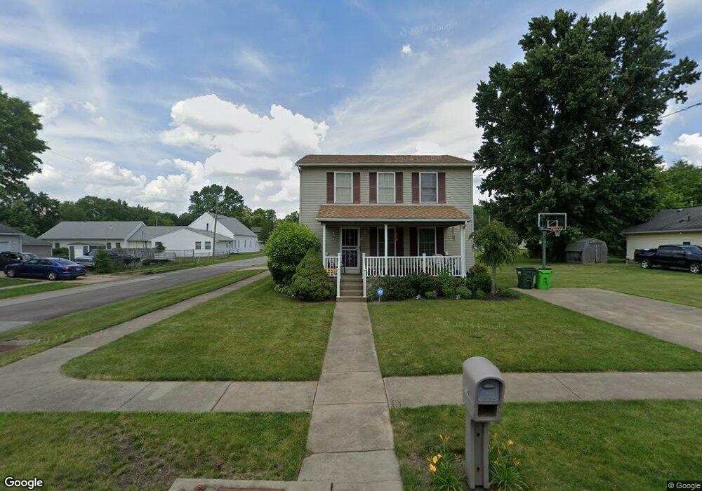
299 Stanley Ave Barberton, OH 44203
East Barberton NeighborhoodEstimated Value: $209,068 - $243,000
3
Beds
2
Baths
2,016
Sq Ft
$112/Sq Ft
Est. Value
About This Home
This home is located at 299 Stanley Ave, Barberton, OH 44203 and is currently estimated at $225,017, approximately $111 per square foot. 299 Stanley Ave is a home located in Summit County with nearby schools including Barberton Middle School, Barberton High School, and St. Francis de Sales School.
Ownership History
Date
Name
Owned For
Owner Type
Purchase Details
Closed on
Apr 17, 2024
Sold by
Roberson Donna J
Bought by
Roberson-Shields Donna J
Current Estimated Value
Purchase Details
Closed on
Jan 15, 2024
Sold by
Roberson Donna J
Bought by
Roberson-Shields Donna J
Purchase Details
Closed on
Nov 2, 2001
Sold by
Matthews Derrick
Bought by
Mclellan Homes Inc
Create a Home Valuation Report for This Property
The Home Valuation Report is an in-depth analysis detailing your home's value as well as a comparison with similar homes in the area
Home Values in the Area
Average Home Value in this Area
Purchase History
| Date | Buyer | Sale Price | Title Company |
|---|---|---|---|
| Roberson-Shields Donna J | -- | None Listed On Document | |
| Roberson-Shields Donna J | -- | None Listed On Document | |
| Mclellan Homes Inc | $6,000 | Bond & Associates Title Agen |
Source: Public Records
Tax History
| Year | Tax Paid | Tax Assessment Tax Assessment Total Assessment is a certain percentage of the fair market value that is determined by local assessors to be the total taxable value of land and additions on the property. | Land | Improvement |
|---|---|---|---|---|
| 2025 | $2,359 | $56,270 | $6,685 | $49,585 |
| 2024 | $2,359 | $56,270 | $6,685 | $49,585 |
| 2023 | $2,359 | $56,270 | $6,685 | $49,585 |
| 2022 | $1,752 | $39,074 | $4,641 | $34,433 |
| 2021 | $1,750 | $39,074 | $4,641 | $34,433 |
| 2020 | $1,713 | $39,070 | $4,640 | $34,430 |
| 2019 | $2,058 | $39,310 | $4,180 | $35,130 |
| 2018 | $1,876 | $39,310 | $4,180 | $35,130 |
| 2017 | $2,206 | $39,310 | $4,180 | $35,130 |
| 2016 | $2,211 | $35,550 | $4,180 | $31,370 |
| 2015 | $2,206 | $35,550 | $4,180 | $31,370 |
| 2014 | $2,293 | $35,550 | $4,180 | $31,370 |
| 2013 | $2,235 | $35,890 | $4,180 | $31,710 |
Source: Public Records
Map
Nearby Homes
- 311 George St
- 455 S Van Buren Ave
- 398 Snyder Ave
- 329 Spruce St
- 43 S Van Buren Ave
- 1283 S Azalea Blvd
- 536 Austin Dr
- 25 S Van Buren Ave
- 580 Glenmere Place
- 163 E Ford Ave
- 687 Lockwood Rd
- 194 E Baird Ave
- 279 E Baird Ave
- 304 E Tuscarawas Ave
- 507 E Ford Ave
- 733 Austin Dr
- 175 2nd St NE Unit 177
- 951 S Azalea Blvd
- 1662 Turkeyfoot Lake Rd
- 679 Wooster Rd W
- 307 Stanley Ave
- 289 Stanley Ave
- 283 Stanley Ave
- 312 Harter Ave
- 317 Stanley Ave
- 277 Stanley Ave
- 304 Stanley Ave
- 284 Stanley Ave
- 308 Stanley Ave
- 323 Stanley Ave
- * Stanley Ave
- v/l Stanley Ave
- v/l Stanley Ave
- 316 Stanley Ave
- * Harter Ave
- 322 Stanley Ave
- 331 Stanley Ave
- 378 George St
- 305 Haven Ave
- 289 Harter Ave
Your Personal Tour Guide
Ask me questions while you tour the home.