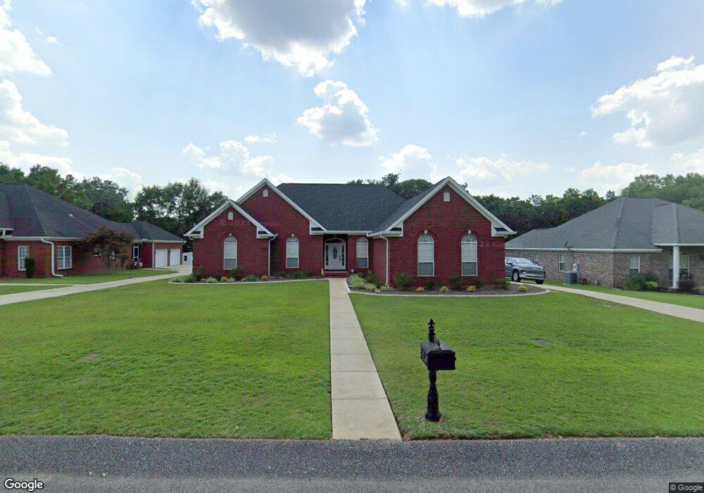
2990 Branson Ct E Mobile, AL 36695
Outer West Mobile NeighborhoodEstimated Value: $241,000 - $402,000
4
Beds
3
Baths
2,434
Sq Ft
$141/Sq Ft
Est. Value
About This Home
This home is located at 2990 Branson Ct E, Mobile, AL 36695 and is currently estimated at $344,384, approximately $141 per square foot. 2990 Branson Ct E is a home located in Mobile County with nearby schools including Hutchens Elementary School, Dawes Intermediate School, and Bernice J Causey Middle School.
Ownership History
Date
Name
Owned For
Owner Type
Purchase Details
Closed on
Oct 4, 2024
Sold by
Fehrenbach Kimberly A and Fehrenbach Carl A
Bought by
Cafkaf Living Trust and Fehrenbach
Current Estimated Value
Purchase Details
Closed on
Jul 22, 2011
Sold by
Augenstine James and Augenstine Karen
Bought by
Fehrenbach Carl A and Fehrenbach Kimberly Archer
Home Financials for this Owner
Home Financials are based on the most recent Mortgage that was taken out on this home.
Original Mortgage
$192,500
Interest Rate
4.52%
Mortgage Type
New Conventional
Purchase Details
Closed on
Jan 18, 2007
Sold by
Greenlee Paul E and Greenlee Carolyn J
Bought by
Augenstine James and Augenstine Karen
Home Financials for this Owner
Home Financials are based on the most recent Mortgage that was taken out on this home.
Original Mortgage
$258,300
Interest Rate
6.08%
Mortgage Type
Unknown
Create a Home Valuation Report for This Property
The Home Valuation Report is an in-depth analysis detailing your home's value as well as a comparison with similar homes in the area
Home Values in the Area
Average Home Value in this Area
Purchase History
| Date | Buyer | Sale Price | Title Company |
|---|---|---|---|
| Cafkaf Living Trust | $299,500 | None Listed On Document | |
| Fehrenbach Carl A | -- | None Available | |
| Augenstine James | $287,000 | Gtc |
Source: Public Records
Mortgage History
| Date | Status | Borrower | Loan Amount |
|---|---|---|---|
| Previous Owner | Fehrenbach Carl A | $192,500 | |
| Previous Owner | Augenstine James | $258,300 |
Source: Public Records
Tax History
| Year | Tax Paid | Tax Assessment Tax Assessment Total Assessment is a certain percentage of the fair market value that is determined by local assessors to be the total taxable value of land and additions on the property. | Land | Improvement |
|---|---|---|---|---|
| 2025 | $1,545 | $31,790 | $4,000 | $27,790 |
| 2024 | $1,545 | $29,940 | $4,000 | $25,940 |
| 2023 | $1,456 | $26,240 | $4,000 | $22,240 |
| 2022 | $1,107 | $24,200 | $4,000 | $20,200 |
| 2021 | $1,129 | $24,650 | $4,000 | $20,650 |
| 2020 | $1,062 | $23,270 | $4,000 | $19,270 |
| 2019 | $1,049 | $23,020 | $0 | $0 |
| 2018 | $1,059 | $23,220 | $0 | $0 |
| 2017 | $1,129 | $23,220 | $0 | $0 |
| 2016 | $1,074 | $23,520 | $0 | $0 |
| 2013 | $1,213 | $25,460 | $0 | $0 |
Source: Public Records
Map
Nearby Homes
- 0 Newman Rd Unit 25399577
- 0 Newman Rd Unit 7652668
- 0 Newman Rd Unit 7670125
- 0 Newman Rd Unit 25537843
- 12171 Yancey Glen Dr
- 13045 Oak Forge Dr
- 3221 Deer Crest Ct
- 13163 Buckthorn Ct
- 13346 Deer Crest Ln
- 3137 Busby Rd
- #77 Deer Crest Dr
- 3397 Deer Crest Dr
- 2865 Barlett Dr
- 2995 Barlett Dr
- 0 Lakefront Dr Unit 7716851
- 12240 Dogwood Cir
- 3761 Lakefront Dr
- 13046 Tara Point Dr
- 3770 Lakefront Dr
- 3835 Lakefront Dr W
- 2980 Branson Ct E
- 3000 Branson Ct E
- 0 Branson Ct E Unit 14 0186436
- 0 Branson Ct E Unit 5 0610531
- 12610 Branson Ln W Unit 7
- 12600 Branson Ln
- 2995 Branson Ct E
- 12550 Branson Ln
- 2975 Branson Ct E
- 12610 Branson Ln Unit 7
- 12540 Branson Ln
- 12540 Branson Rd Unit 21
- 2965 Branson Ct E
- 12605 Branson Ln
- 3035 Branson Rd W
- 3030 Branson Ct W
- 3035 Branson Ct W
- 3010 Branson Ct W
- 2990 Branson Rd W
- 12545 Branson Ln
Your Personal Tour Guide
Ask me questions while you tour the home.