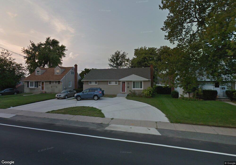
2999 Brower Ave Oceanside, NY 11572
Estimated Value: $683,000 - $697,325
3
Beds
1
Bath
1,032
Sq Ft
$669/Sq Ft
Est. Value
About This Home
This home is located at 2999 Brower Ave, Oceanside, NY 11572 and is currently estimated at $690,163, approximately $668 per square foot. 2999 Brower Ave is a home located in Nassau County with nearby schools including Oaks Elementary School - School 3, Oceanside Middle School, and Oceanside High School.
Ownership History
Date
Name
Owned For
Owner Type
Purchase Details
Closed on
Feb 21, 2016
Sold by
Frankel Matthew and Last Will And Testament Of Kei
Bought by
Frankel Matthew and Testamentary Trust Established
Current Estimated Value
Purchase Details
Closed on
Jul 15, 2011
Sold by
Montagnino Michael and Montagnino Diane
Bought by
Lane Keith
Home Financials for this Owner
Home Financials are based on the most recent Mortgage that was taken out on this home.
Original Mortgage
$100,000
Outstanding Balance
$68,830
Interest Rate
4.52%
Mortgage Type
Purchase Money Mortgage
Estimated Equity
$621,334
Purchase Details
Closed on
Sep 30, 2004
Sold by
Montagnino Michael
Create a Home Valuation Report for This Property
The Home Valuation Report is an in-depth analysis detailing your home's value as well as a comparison with similar homes in the area
Home Values in the Area
Average Home Value in this Area
Purchase History
| Date | Buyer | Sale Price | Title Company |
|---|---|---|---|
| Frankel Matthew | -- | Abstracts Incorporated | |
| Lane Keith | $337,500 | -- | |
| -- | $302,500 | -- |
Source: Public Records
Mortgage History
| Date | Status | Borrower | Loan Amount |
|---|---|---|---|
| Open | Lane Keith | $100,000 |
Source: Public Records
Tax History Compared to Growth
Tax History
| Year | Tax Paid | Tax Assessment Tax Assessment Total Assessment is a certain percentage of the fair market value that is determined by local assessors to be the total taxable value of land and additions on the property. | Land | Improvement |
|---|---|---|---|---|
| 2025 | $10,963 | $441 | $204 | $237 |
| 2024 | $3,222 | $441 | $204 | $237 |
| 2023 | $9,172 | $441 | $204 | $237 |
| 2022 | $9,172 | $441 | $204 | $237 |
| 2021 | $12,449 | $426 | $197 | $229 |
| 2020 | $9,297 | $707 | $562 | $145 |
| 2019 | $3,189 | $707 | $562 | $145 |
| 2018 | $5,779 | $707 | $0 | $0 |
| 2017 | $4,986 | $707 | $562 | $145 |
| 2016 | $7,897 | $707 | $562 | $145 |
| 2015 | $2,781 | $707 | $562 | $145 |
| 2014 | $2,781 | $707 | $562 | $145 |
| 2013 | $2,536 | $693 | $562 | $131 |
Source: Public Records
Map
Nearby Homes
- 2860 Lenox Rd
- 226 Oakview Ave
- 385 Oceanside Pkwy
- 3067 Xavier Ct
- 2975 Oceanside Rd
- 3068 Xavier Place
- 2922 Oceanside Rd
- 254 Elizabeth Ave
- 3309 Balsam St
- 3328 Woodward St
- 484 Chelsea Rd
- 3354 Knight St
- 138 Davison Ave
- 3309 Skillman Ave
- 515 Chelsea Rd
- 25 Sunnybrook Dr E
- 2941 Moreland Ave
- 3420 Woodward St
- 2593 Loftus Ave
- 3432 Bayfield Blvd
- 2993 Brower Ave
- 3005 Brower Ave
- 2964 Harvey Ave
- 2970 Harvey Ave
- 3011 Brower Ave
- 2981 Brower Ave
- 2958 Harvey Ave
- 2976 Harvey Ave
- 3017 Brower Ave
- 3074 Brower Ave
- 3074 Ralph Ave
- 2992 Brower Ave
- 2957 Marlborough Rd
- 2982 Harvey Ave
- 3075 Ralph Ave
- 2952 Harvey Ave
- 2951 Marlborough Rd
- 3082 Ralph Ave
- 3081 Skillman Ave
- 3025 Brower Ave