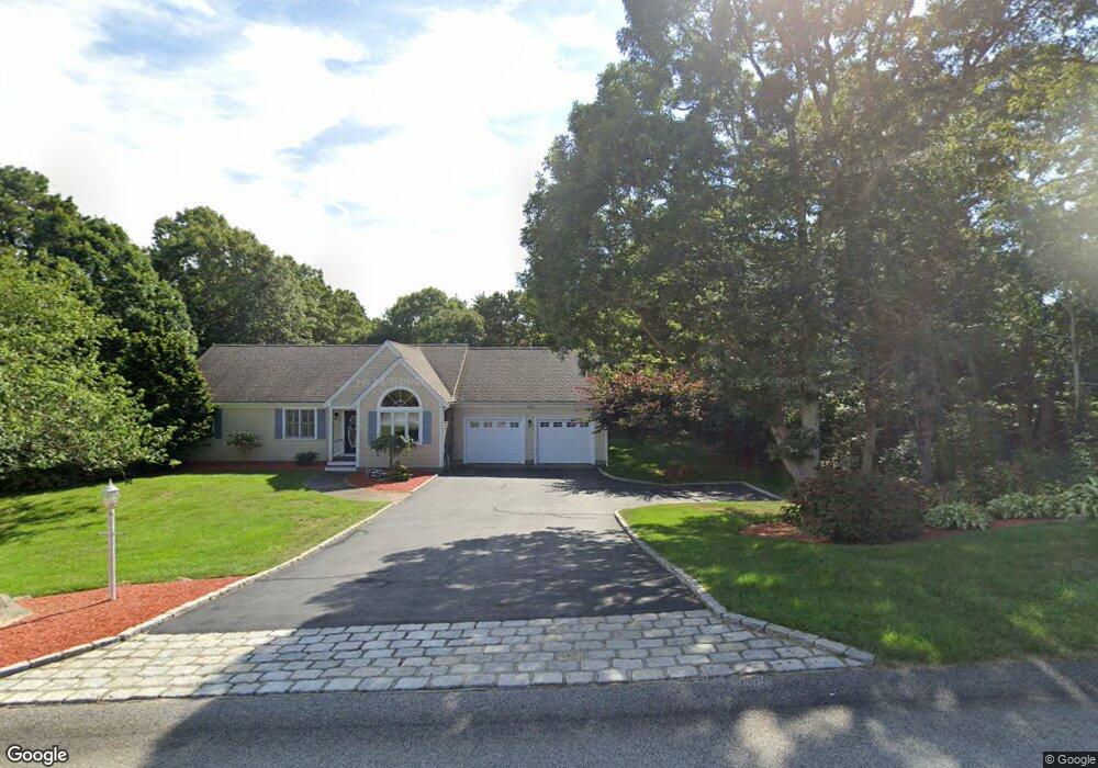
3 Alexander Dr Yarmouth Port, MA 2675
Yarmouth Port NeighborhoodEstimated Value: $546,751 - $1,079,000
3
Beds
2
Baths
1,064
Sq Ft
$658/Sq Ft
Est. Value
About This Home
This home is located at 3 Alexander Dr, Yarmouth Port, MA 2675 and is currently estimated at $699,938, approximately $657 per square foot. 3 Alexander Dr is a home located in Barnstable County with nearby schools including Dennis-Yarmouth Regional High School.
Ownership History
Date
Name
Owned For
Owner Type
Purchase Details
Closed on
May 15, 2024
Sold by
Ducharme Cynthia
Bought by
Lemos Christopher and Greenberg-Lemos Hillary
Current Estimated Value
Purchase Details
Closed on
Aug 28, 1985
Bought by
Lemos Cynthia N
Create a Home Valuation Report for This Property
The Home Valuation Report is an in-depth analysis detailing your home's value as well as a comparison with similar homes in the area
Home Values in the Area
Average Home Value in this Area
Purchase History
| Date | Buyer | Sale Price | Title Company |
|---|---|---|---|
| Lemos Christopher | -- | None Available | |
| Lemos Christopher | -- | None Available | |
| Lemos Christopher | -- | None Available | |
| Lemos Cynthia N | $80,000 | -- |
Source: Public Records
Mortgage History
| Date | Status | Borrower | Loan Amount |
|---|---|---|---|
| Previous Owner | Lemos Cynthia N | $64,300 |
Source: Public Records
Tax History Compared to Growth
Tax History
| Year | Tax Paid | Tax Assessment Tax Assessment Total Assessment is a certain percentage of the fair market value that is determined by local assessors to be the total taxable value of land and additions on the property. | Land | Improvement |
|---|---|---|---|---|
| 2025 | $2,057 | $475,000 | $133,000 | $342,000 |
| 2024 | $1,951 | $444,400 | $127,900 | $316,500 |
| 2023 | $1,888 | $404,200 | $116,300 | $287,900 |
| 2022 | $1,847 | $329,900 | $116,400 | $213,500 |
| 2021 | $1,752 | $290,500 | $114,100 | $176,400 |
| 2020 | $1,673 | $274,200 | $114,100 | $160,100 |
| 2019 | $1,649 | $267,300 | $123,100 | $144,200 |
| 2018 | $1,507 | $237,700 | $106,500 | $131,200 |
| 2017 | $1,436 | $233,500 | $106,500 | $127,000 |
| 2016 | $1,282 | $196,300 | $111,800 | $84,500 |
| 2015 | $1,256 | $196,300 | $111,800 | $84,500 |
| 2014 | $1,274 | $200,600 | $95,900 | $104,700 |
Source: Public Records
Map
Nearby Homes
- 6 Nimble Hill Dr
- 59 Main St Unit 19-2
- 59 Route 6a Unit 29-4
- 51 Bray Farm Rd N
- 44 Stratford Ln
- 64 Kates Path
- 34 Kates Path
- 34 Kates Path Unit 34
- 42 John Hall Cartway Unit 42
- 228 Kates Path
- 17 Kates Path Unit A
- 50 John Hall Cartway
- 50 John Hall Cartway Unit 50
- 268 Main St
- 43 Canterbury Rd
- 13 Covey Dr
- 111 Merchant Ave
- 86 Pompano Rd
- 7 Forest Gate Unit 7
- 25 Oak Glen Village Unit 25
- 5 Alexander Dr
- 77 Main Street Rte 6a St
- 4 Alexander Dr
- 13 Alexander Dr
- 953 Route 6a
- 12 Alexander Dr
- 960 Massachusetts 6a
- 960 Route 6a
- 964 Massachusetts 6a
- 964 Route 6a
- 964R Route 6a St
- 19 Alexander Dr
- 947 Route 6a Unit 8
- 947 Route 6a
- 979 Route 6a
- 11 Ironwood Ct
- 16 Dover Rd
- 968 Route 6a
- 12 Dover Rd
- 8 Ironwood Ct