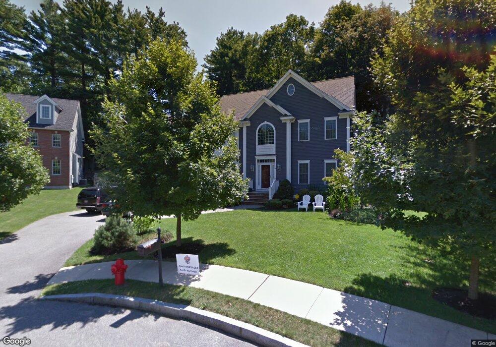
3 Andrea Cir Winchester, MA 01890
Winchester Highlands NeighborhoodEstimated Value: $2,152,205 - $2,277,000
4
Beds
4
Baths
5,066
Sq Ft
$434/Sq Ft
Est. Value
About This Home
This home is located at 3 Andrea Cir, Winchester, MA 01890 and is currently estimated at $2,200,051, approximately $434 per square foot. 3 Andrea Cir is a home located in Middlesex County with nearby schools including Muraco Elementary School, McCall Middle School, and Winchester High School.
Ownership History
Date
Name
Owned For
Owner Type
Purchase Details
Closed on
Mar 3, 2024
Sold by
Ferrelli F P F and Ferrelli Teresa C
Bought by
Teresa C Ferrelli 2022 T C and Teresa Ferrelli
Current Estimated Value
Purchase Details
Closed on
Aug 20, 2004
Sold by
Rayvon Rt and Cormier
Bought by
Ferrelli F Peter F and Ferrelli Teresa C
Create a Home Valuation Report for This Property
The Home Valuation Report is an in-depth analysis detailing your home's value as well as a comparison with similar homes in the area
Home Values in the Area
Average Home Value in this Area
Purchase History
| Date | Buyer | Sale Price | Title Company |
|---|---|---|---|
| Teresa C Ferrelli 2022 T C | -- | None Available | |
| Ferrelli F Peter F | $1,164,000 | -- |
Source: Public Records
Tax History Compared to Growth
Tax History
| Year | Tax Paid | Tax Assessment Tax Assessment Total Assessment is a certain percentage of the fair market value that is determined by local assessors to be the total taxable value of land and additions on the property. | Land | Improvement |
|---|---|---|---|---|
| 2025 | $185 | $1,671,000 | $683,100 | $987,900 |
| 2024 | $18,106 | $1,598,100 | $683,100 | $915,000 |
| 2023 | $17,793 | $1,507,900 | $614,800 | $893,100 |
| 2022 | $17,565 | $1,404,100 | $529,400 | $874,700 |
| 2021 | $17,356 | $1,352,800 | $478,100 | $874,700 |
| 2020 | $16,761 | $1,352,800 | $478,100 | $874,700 |
| 2019 | $16,177 | $1,335,800 | $461,100 | $874,700 |
| 2018 | $15,721 | $1,289,700 | $439,700 | $850,000 |
| 2017 | $15,421 | $1,255,800 | $439,700 | $816,100 |
| 2016 | $14,373 | $1,230,600 | $439,700 | $790,900 |
| 2015 | $13,888 | $1,144,000 | $383,400 | $760,600 |
| 2014 | $13,760 | $1,086,900 | $333,000 | $753,900 |
Source: Public Records
Map
Nearby Homes
- 571 Washington St
- 19 Mason Way Unit 75
- 17 Mason Way Unit 74
- 2 Mason Way Unit 6524
- 6 Mason Way Unit 6324
- 95 Irving St
- 18 Raymond Place
- 2 George Rd Unit 2
- 82 Hillcrest Pkwy
- 2 Stratton Dr Unit 1109
- 35 Grape St
- 171 Swanton St Unit 73
- 21 Park Ave
- 46-48 Swanton St
- 32 Oak St
- 3 Frank St
- 6 Stratton Dr Unit 307
- 6 Stratton Dr Unit 404
- 6 Stratton Dr Unit 208
- 6 Stratton Dr Unit 303
- 5 Andrea Cir
- 1 Andrea Cir
- 118 Forest St
- 124 Forest St
- 120 Forest St
- 597 Washington St
- 128 Forest St
- 569 Washington St
- 586 Washington St
- 3 Brookside Ave
- 3 Sunset Rd
- 116 Forest St
- 130 Forest St
- 8 Brookside Ave Unit 8
- 5 Sunset Rd
- 6 Brookside Ave
- 6 Brookside Ave Unit 6
- 9 Brookside Ave
- 5 Sawmill Brook Rd
- 125 Forest St