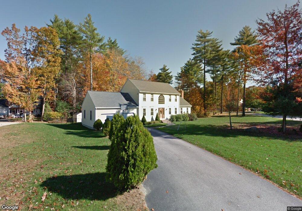
3 Brandy Wine Cir Douglas, MA 01516
Estimated Value: $584,082 - $732,000
4
Beds
3
Baths
1,954
Sq Ft
$335/Sq Ft
Est. Value
About This Home
This home is located at 3 Brandy Wine Cir, Douglas, MA 01516 and is currently estimated at $654,021, approximately $334 per square foot. 3 Brandy Wine Cir is a home located in Worcester County with nearby schools including Douglas Primary School, Douglas Middle School, and Douglas High School.
Ownership History
Date
Name
Owned For
Owner Type
Purchase Details
Closed on
Aug 8, 2024
Sold by
Keeman Robert C and Keeman Paula E
Bought by
Keeman Paula E and Keeman Robert C
Current Estimated Value
Home Financials for this Owner
Home Financials are based on the most recent Mortgage that was taken out on this home.
Original Mortgage
$461,538
Outstanding Balance
$450,996
Interest Rate
6.75%
Mortgage Type
FHA
Estimated Equity
$203,025
Purchase Details
Closed on
Mar 27, 1997
Sold by
Audet Builders Inc
Bought by
Keeman Robert C and Keeman Paula E
Create a Home Valuation Report for This Property
The Home Valuation Report is an in-depth analysis detailing your home's value as well as a comparison with similar homes in the area
Home Values in the Area
Average Home Value in this Area
Purchase History
| Date | Buyer | Sale Price | Title Company |
|---|---|---|---|
| Keeman Paula E | -- | None Available | |
| Keeman Paula E | -- | None Available | |
| Keeman Robert C | $182,400 | -- | |
| Keeman Robert C | $182,400 | -- |
Source: Public Records
Mortgage History
| Date | Status | Borrower | Loan Amount |
|---|---|---|---|
| Open | Keeman Paula E | $461,538 | |
| Closed | Keeman Paula E | $461,538 | |
| Previous Owner | Keeman Robert C | $267,000 | |
| Previous Owner | Keeman Robert C | $232,000 | |
| Previous Owner | Keeman Robert C | $180,000 |
Source: Public Records
Tax History
| Year | Tax Paid | Tax Assessment Tax Assessment Total Assessment is a certain percentage of the fair market value that is determined by local assessors to be the total taxable value of land and additions on the property. | Land | Improvement |
|---|---|---|---|---|
| 2025 | $66 | $497,600 | $115,800 | $381,800 |
| 2024 | $6,438 | $476,200 | $105,300 | $370,900 |
| 2023 | $6,303 | $438,900 | $105,300 | $333,600 |
| 2022 | $6,178 | $378,100 | $87,100 | $291,000 |
| 2021 | $7,831 | $364,200 | $82,900 | $281,300 |
| 2020 | $7,415 | $350,100 | $82,900 | $267,200 |
| 2019 | $5,766 | $329,500 | $82,900 | $246,600 |
| 2018 | $5,138 | $319,700 | $82,900 | $236,800 |
| 2017 | $4,849 | $290,000 | $80,600 | $209,400 |
| 2016 | $4,710 | $280,000 | $80,600 | $199,400 |
| 2015 | $4,609 | $280,000 | $80,600 | $199,400 |
Source: Public Records
Map
Nearby Homes
Your Personal Tour Guide
Ask me questions while you tour the home.