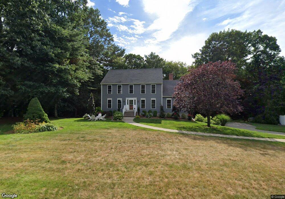
3 Brandywine Rd Medway, MA 02053
Estimated Value: $824,398 - $937,000
4
Beds
3
Baths
2,600
Sq Ft
$343/Sq Ft
Est. Value
About This Home
This home is located at 3 Brandywine Rd, Medway, MA 02053 and is currently estimated at $892,100, approximately $343 per square foot. 3 Brandywine Rd is a home located in Norfolk County with nearby schools including John D. McGovern Elementary School, Burke-Memorial Elementary, and Medway Middle School.
Ownership History
Date
Name
Owned For
Owner Type
Purchase Details
Closed on
Apr 20, 2007
Sold by
Dimillo David A
Bought by
Bartel Brian M and Bartel Tina M
Current Estimated Value
Home Financials for this Owner
Home Financials are based on the most recent Mortgage that was taken out on this home.
Original Mortgage
$323,940
Interest Rate
6.19%
Mortgage Type
Purchase Money Mortgage
Purchase Details
Closed on
Oct 24, 1997
Sold by
Hall Michael H and Hall Janice A
Bought by
Dimillo David A
Purchase Details
Closed on
Jan 9, 1996
Sold by
Glynn Homes Inc
Bought by
Hall Michael H and Hall Janice A
Purchase Details
Closed on
Jun 8, 1995
Sold by
Glenmore Corp
Bought by
Glynn Homes Inc
Create a Home Valuation Report for This Property
The Home Valuation Report is an in-depth analysis detailing your home's value as well as a comparison with similar homes in the area
Home Values in the Area
Average Home Value in this Area
Purchase History
| Date | Buyer | Sale Price | Title Company |
|---|---|---|---|
| Bartel Brian M | $539,900 | -- | |
| Dimillo David A | $270,000 | -- | |
| Hall Michael H | $249,000 | -- | |
| Glynn Homes Inc | $65,000 | -- |
Source: Public Records
Mortgage History
| Date | Status | Borrower | Loan Amount |
|---|---|---|---|
| Open | Glynn Homes Inc | $308,877 | |
| Closed | Bartel Brian M | $323,940 | |
| Previous Owner | Glynn Homes Inc | $200,000 |
Source: Public Records
Tax History
| Year | Tax Paid | Tax Assessment Tax Assessment Total Assessment is a certain percentage of the fair market value that is determined by local assessors to be the total taxable value of land and additions on the property. | Land | Improvement |
|---|---|---|---|---|
| 2025 | $10,542 | $739,800 | $325,700 | $414,100 |
| 2024 | $10,653 | $739,800 | $325,700 | $414,100 |
| 2023 | $10,495 | $658,400 | $296,700 | $361,700 |
| 2022 | $9,476 | $559,700 | $220,200 | $339,500 |
| 2021 | $9,383 | $537,400 | $205,700 | $331,700 |
| 2020 | $9,179 | $524,500 | $205,700 | $318,800 |
| 2019 | $8,673 | $511,100 | $197,400 | $313,700 |
| 2018 | $7,996 | $452,800 | $189,100 | $263,700 |
| 2017 | $7,897 | $440,700 | $185,000 | $255,700 |
| 2016 | $7,878 | $435,000 | $179,300 | $255,700 |
| 2015 | $7,747 | $424,700 | $177,100 | $247,600 |
| 2014 | $7,773 | $412,600 | $180,000 | $232,600 |
Source: Public Records
Map
Nearby Homes
- 6 Freedom Trail
- 2 Kingson Ln Unit 2
- 6 Kingson Ln Unit 2
- 10 Franklin St
- 8 Winthrop St
- 1391 Pond St
- 19 Evergreen St Unit A
- 39 West St
- 4 Linda Ln
- 56 Fisher St
- 462 Hartford Ave
- 3 Nobscott Rd
- 79 Lovering St Unit B
- 18 Mary Anne Dr
- 3 Thayer Rd
- 23 Cedar Farms Rd
- 253 Village St
- 58 Holliston St
- 26 Timber Crest Dr
- 22 Granite St
Your Personal Tour Guide
Ask me questions while you tour the home.