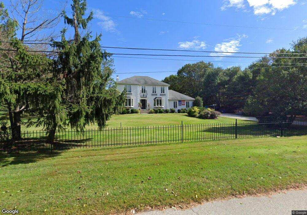
3 Commonwealth Dr Medford, NJ 08055
Estimated Value: $806,581 - $912,000
4
Beds
3
Baths
2,725
Sq Ft
$309/Sq Ft
Est. Value
About This Home
This home is located at 3 Commonwealth Dr, Medford, NJ 08055 and is currently estimated at $840,895, approximately $308 per square foot. 3 Commonwealth Dr is a home located in Burlington County with nearby schools including Haines Memorial 6th Grade Center, Medford Township Memorial School, and Shawnee High School.
Ownership History
Date
Name
Owned For
Owner Type
Purchase Details
Closed on
Jan 22, 2010
Sold by
Harkay John R and Harkay Loren
Bought by
Giordano Michael M and Giordano Kim M
Current Estimated Value
Home Financials for this Owner
Home Financials are based on the most recent Mortgage that was taken out on this home.
Original Mortgage
$350,000
Outstanding Balance
$229,795
Interest Rate
4.95%
Mortgage Type
New Conventional
Estimated Equity
$611,100
Purchase Details
Closed on
Nov 30, 2004
Sold by
Baldwin Harlan J and Baldwin Birgit A
Bought by
Harkay John R and Harkay Loren
Home Financials for this Owner
Home Financials are based on the most recent Mortgage that was taken out on this home.
Original Mortgage
$91,000
Interest Rate
5.13%
Mortgage Type
Stand Alone Second
Purchase Details
Closed on
Jun 24, 1996
Sold by
Gove J Steven and Gove Jonnie J
Bought by
Baldwin Birgit A and Baldwin Harlan J
Create a Home Valuation Report for This Property
The Home Valuation Report is an in-depth analysis detailing your home's value as well as a comparison with similar homes in the area
Home Values in the Area
Average Home Value in this Area
Purchase History
| Date | Buyer | Sale Price | Title Company |
|---|---|---|---|
| Giordano Michael M | $482,000 | Group 21 Title Agency | |
| Harkay John R | $455,000 | Commonwealth Land Title Insu | |
| Baldwin Birgit A | $225,000 | -- |
Source: Public Records
Mortgage History
| Date | Status | Borrower | Loan Amount |
|---|---|---|---|
| Open | Giordano Michael M | $350,000 | |
| Previous Owner | Harkay John R | $91,000 |
Source: Public Records
Tax History Compared to Growth
Tax History
| Year | Tax Paid | Tax Assessment Tax Assessment Total Assessment is a certain percentage of the fair market value that is determined by local assessors to be the total taxable value of land and additions on the property. | Land | Improvement |
|---|---|---|---|---|
| 2025 | $13,724 | $386,700 | $97,800 | $288,900 |
| 2024 | $12,831 | $386,700 | $97,800 | $288,900 |
| 2023 | $12,831 | $386,700 | $97,800 | $288,900 |
| 2022 | $12,568 | $386,700 | $97,800 | $288,900 |
| 2021 | $12,928 | $400,000 | $97,800 | $302,200 |
| 2020 | $12,848 | $400,000 | $97,800 | $302,200 |
| 2019 | $12,676 | $400,000 | $97,800 | $302,200 |
| 2018 | $12,500 | $400,000 | $97,800 | $302,200 |
| 2017 | $12,412 | $400,000 | $97,800 | $302,200 |
| 2016 | $12,368 | $400,000 | $97,800 | $302,200 |
| 2015 | $12,184 | $400,000 | $97,800 | $302,200 |
| 2014 | $11,812 | $400,000 | $97,800 | $302,200 |
Source: Public Records
Map
Nearby Homes
- 9 Hawthorne Dr
- 35 Cranberry Ct
- 37 Cranberry Ct
- 155 Tuckerton Rd
- 18 Tomahawk Ct
- 77 Wigwam Ct
- 178 Nahma Trail
- 0 Tuckerton and Atsion Rd
- 13 Running Water Ct
- 125 Sitting Bull Trail
- 2 Wellington Ct
- 4 Grand Coach Ct
- 0 Jackson Rd Unit NJBL2085060
- 109 Mohawk Trail
- 5 Pleasant Mill Ct
- 112 Setauket Trail
- 114 Hiawatha Trail
- 55 Wrentham Dr Unit 69
- 1 Knotty Oak Dr
- 28 Brattleboro Ct Unit 7
- 5 Commonwealth Dr
- 174 Cowpath Rd
- 2 Cowpath Rd
- 524 Cowpath Rd
- 16 Wethersfield Dr
- 4 Cowpath Rd
- 14 Wethersfield Dr
- 12 Wethersfield Dr
- 1 Conestoga Ct
- 179 Cowpath Rd
- 2 Conestoga Ct
- 15 Wethersfield Dr
- 4 Bookbinder Ct
- 169 Cowpath Rd
- 159 Cowpath Rd
- 10 Wethersfield Dr
- 3 Conestoga Ct
- 4 Conestoga Ct
- 3 Bookbinder Ct
- 8 Wethersfield Dr