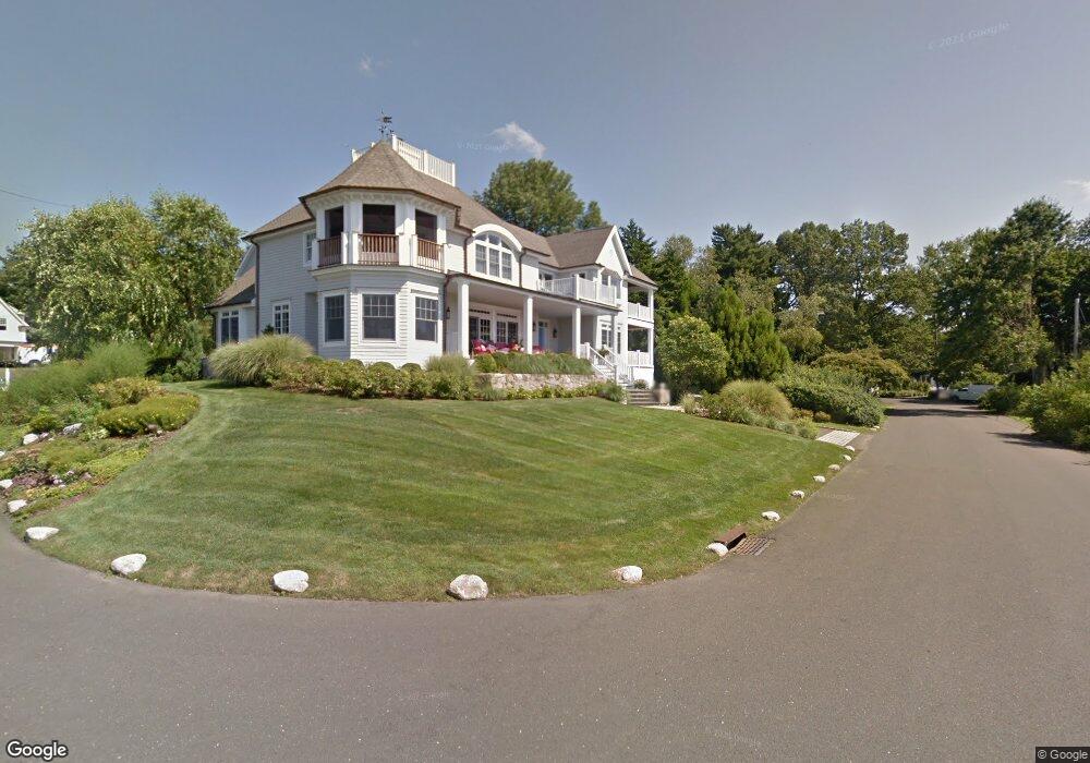
3 Cove Ridge Ln Old Greenwich, CT 06870
Old Greenwich NeighborhoodEstimated Value: $3,096,000 - $4,790,000
3
Beds
5
Baths
3,070
Sq Ft
$1,295/Sq Ft
Est. Value
About This Home
This home is located at 3 Cove Ridge Ln, Old Greenwich, CT 06870 and is currently estimated at $3,976,688, approximately $1,295 per square foot. 3 Cove Ridge Ln is a home located in Fairfield County with nearby schools including Old Greenwich School, Eastern Middle School, and Greenwich High School.
Ownership History
Date
Name
Owned For
Owner Type
Purchase Details
Closed on
Apr 13, 2017
Sold by
Cerussi Kathryn
Bought by
Cerussi Kathryn
Current Estimated Value
Purchase Details
Closed on
Jul 26, 2011
Sold by
Benson Robert C and Benson Beverly M
Bought by
Cerussi Kathryn Z
Home Financials for this Owner
Home Financials are based on the most recent Mortgage that was taken out on this home.
Original Mortgage
$138,000
Interest Rate
4.63%
Purchase Details
Closed on
Sep 28, 2000
Sold by
Est Woodruff Alling and Scott George W
Bought by
Benson Robert C and Benson Beverly M
Home Financials for this Owner
Home Financials are based on the most recent Mortgage that was taken out on this home.
Original Mortgage
$1,000,000
Interest Rate
8.83%
Create a Home Valuation Report for This Property
The Home Valuation Report is an in-depth analysis detailing your home's value as well as a comparison with similar homes in the area
Home Values in the Area
Average Home Value in this Area
Purchase History
| Date | Buyer | Sale Price | Title Company |
|---|---|---|---|
| Cerussi Kathryn | -- | -- | |
| Cerussi Kathryn Z | $3,590,000 | -- | |
| Benson Robert C | $1,387,500 | -- |
Source: Public Records
Mortgage History
| Date | Status | Borrower | Loan Amount |
|---|---|---|---|
| Previous Owner | Benson Robert C | $138,000 | |
| Previous Owner | Benson Robert C | $1,000,000 |
Source: Public Records
Tax History Compared to Growth
Tax History
| Year | Tax Paid | Tax Assessment Tax Assessment Total Assessment is a certain percentage of the fair market value that is determined by local assessors to be the total taxable value of land and additions on the property. | Land | Improvement |
|---|---|---|---|---|
| 2025 | $27,562 | $2,230,130 | $1,310,120 | $920,010 |
| 2024 | $26,619 | $2,230,130 | $1,310,120 | $920,010 |
| 2023 | $25,950 | $2,230,130 | $1,310,120 | $920,010 |
| 2022 | $25,713 | $2,230,130 | $1,310,120 | $920,010 |
| 2021 | $26,116 | $2,169,090 | $1,117,760 | $1,051,330 |
| 2020 | $26,072 | $2,169,090 | $1,117,760 | $1,051,330 |
| 2019 | $26,333 | $2,169,090 | $1,117,760 | $1,051,330 |
| 2018 | $25,747 | $2,169,090 | $1,117,760 | $1,051,330 |
| 2017 | $26,070 | $2,169,090 | $1,117,760 | $1,051,330 |
| 2016 | $25,633 | $2,166,990 | $1,117,760 | $1,049,230 |
| 2015 | $19,174 | $1,607,900 | $922,250 | $685,650 |
| 2014 | $18,692 | $1,607,900 | $922,250 | $685,650 |
Source: Public Records
Map
Nearby Homes
- 7 Cove Ridge Ln
- 4 Cove Ridge Ln
- 11 Cove Ridge Ln
- 8 Cove Ridge Ln
- 32 Hendrie Dr
- 12 Cove Ridge Ln
- 14 Cove Ridge Ln
- 21 Hendrie Dr
- 28 Hendrie Dr
- 23 Hendrie Drive Extension
- 18 Hendrie Dr
- 24 Hendrie Dr
- 24 Hendrie Dr
- 24 Hendrie Dr
- 21 Old Club House Rd
- 31 Heusted Dr
- 31 Heusted Dr
- 33 Heusted Dr
- 25 Heusted Dr
- 21 Heusted Dr