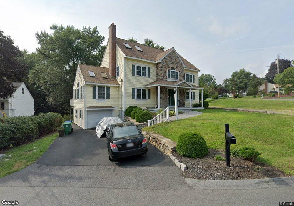
3 Duncan Rd Burlington, MA 01803
Burlington Town Center NeighborhoodEstimated Value: $996,000 - $1,190,409
4
Beds
3
Baths
2,662
Sq Ft
$412/Sq Ft
Est. Value
About This Home
This home is located at 3 Duncan Rd, Burlington, MA 01803 and is currently estimated at $1,096,852, approximately $412 per square foot. 3 Duncan Rd is a home located in Middlesex County with nearby schools including Burlington High School, Memorial Elementary School, and Marshall Simonds Middle School.
Ownership History
Date
Name
Owned For
Owner Type
Purchase Details
Closed on
Sep 5, 2024
Sold by
Tomao Charlotte L
Bought by
Charlotte L Tomao Rt and Tomao
Current Estimated Value
Purchase Details
Closed on
Feb 3, 2014
Sold by
Tomaso Charlotte L and Tomaso Geno J
Bought by
Tomaso Charlotte L
Purchase Details
Closed on
Feb 24, 2004
Sold by
Sweeney Rosemarie T
Bought by
Tomao Charlotte and Tomao Geno
Purchase Details
Closed on
Jun 16, 1995
Sold by
Int Phalen and Day Gail A
Bought by
Sweeney Ii Charles H and Sweeney Rosemarie T
Create a Home Valuation Report for This Property
The Home Valuation Report is an in-depth analysis detailing your home's value as well as a comparison with similar homes in the area
Home Values in the Area
Average Home Value in this Area
Purchase History
| Date | Buyer | Sale Price | Title Company |
|---|---|---|---|
| Charlotte L Tomao Rt | -- | None Available | |
| Charlotte L Tomao Rt | -- | None Available | |
| Tomaso Charlotte L | -- | -- | |
| Tomao Charlotte | -- | -- | |
| Sweeney Rosemarie T | -- | -- | |
| Sweeney Ii Charles H | $154,000 | -- | |
| Tomaso Charlotte L | -- | -- | |
| Tomao Charlotte | -- | -- | |
| Sweeney Charles H | $154,000 | -- |
Source: Public Records
Mortgage History
| Date | Status | Borrower | Loan Amount |
|---|---|---|---|
| Previous Owner | Sweeney Charles H | $75,000 | |
| Previous Owner | Sweeney Charles H | $40,000 | |
| Previous Owner | Sweeney Charles H | $153,000 |
Source: Public Records
Tax History Compared to Growth
Tax History
| Year | Tax Paid | Tax Assessment Tax Assessment Total Assessment is a certain percentage of the fair market value that is determined by local assessors to be the total taxable value of land and additions on the property. | Land | Improvement |
|---|---|---|---|---|
| 2025 | $7,148 | $825,400 | $383,600 | $441,800 |
| 2024 | $6,853 | $766,500 | $353,800 | $412,700 |
| 2023 | $6,689 | $711,600 | $306,900 | $404,700 |
| 2022 | $6,468 | $650,000 | $283,400 | $366,600 |
| 2021 | $6,207 | $623,800 | $257,200 | $366,600 |
| 2020 | $5,970 | $619,300 | $252,700 | $366,600 |
| 2019 | $5,777 | $551,200 | $230,100 | $321,100 |
| 2018 | $7,183 | $540,400 | $219,300 | $321,100 |
| 2017 | $5,620 | $540,400 | $219,300 | $321,100 |
| 2016 | $5,578 | $486,700 | $189,500 | $297,200 |
| 2015 | $5,524 | $486,700 | $189,500 | $297,200 |
| 2014 | $5,575 | $464,600 | $180,500 | $284,100 |
Source: Public Records
Map
Nearby Homes
- 94 Center St
- 137 Winn St
- 4 Ardmore Ave
- 29 Overlook Ave
- 61 Villagewood Dr
- 29 Grove Ln Unit 29
- 50 Hill Cir
- 12 Maple Ridge Dr
- 5 Maple Ridge Dr Unit 5
- 112 Pearl St Unit B
- 17 Sunnyside Rd
- 16 Sunnyside Rd
- 6 Kendal Dr
- 210 Winn St
- 129 Cambridge St Unit 1
- 19 Quimby Ave
- 9 Pilgrim Rd
- 6 Tidd Ave
- 846 Main St
- 42 Mill St