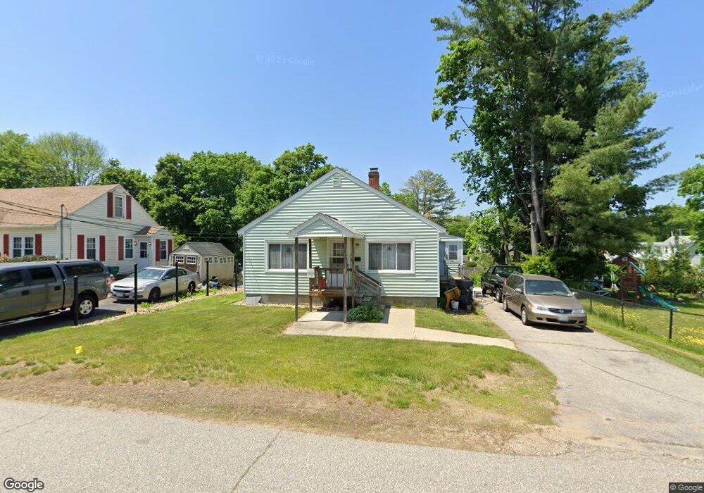
3 Howe St Rochester, NH 03867
Estimated Value: $291,782 - $357,000
3
Beds
1
Bath
1,008
Sq Ft
$333/Sq Ft
Est. Value
About This Home
This home is located at 3 Howe St, Rochester, NH 03867 and is currently estimated at $335,196, approximately $332 per square foot. 3 Howe St is a home located in Strafford County with nearby schools including William Allen School, Rochester Middle School, and Spaulding High School.
Ownership History
Date
Name
Owned For
Owner Type
Purchase Details
Closed on
Jun 24, 2005
Sold by
Brown Alice M
Bought by
Dalton Timothy J
Current Estimated Value
Home Financials for this Owner
Home Financials are based on the most recent Mortgage that was taken out on this home.
Original Mortgage
$162,008
Outstanding Balance
$82,174
Interest Rate
5.82%
Estimated Equity
$253,022
Create a Home Valuation Report for This Property
The Home Valuation Report is an in-depth analysis detailing your home's value as well as a comparison with similar homes in the area
Home Values in the Area
Average Home Value in this Area
Purchase History
| Date | Buyer | Sale Price | Title Company |
|---|---|---|---|
| Dalton Timothy J | $177,000 | -- | |
| Dalton Timothy J | $177,000 | -- |
Source: Public Records
Mortgage History
| Date | Status | Borrower | Loan Amount |
|---|---|---|---|
| Open | Dalton Timothy J | $162,008 | |
| Closed | Dalton Timothy J | $162,008 |
Source: Public Records
Tax History
| Year | Tax Paid | Tax Assessment Tax Assessment Total Assessment is a certain percentage of the fair market value that is determined by local assessors to be the total taxable value of land and additions on the property. | Land | Improvement |
|---|---|---|---|---|
| 2025 | $3,874 | $253,200 | $83,500 | $169,700 |
| 2024 | $3,760 | $253,200 | $83,500 | $169,700 |
| 2023 | $4,275 | $166,100 | $68,000 | $98,100 |
| 2022 | $4,199 | $166,100 | $68,000 | $98,100 |
| 2021 | $4,094 | $166,100 | $68,000 | $98,100 |
| 2020 | $4,088 | $166,100 | $68,000 | $98,100 |
| 2019 | $3,927 | $157,700 | $68,000 | $89,700 |
| 2018 | $3,616 | $131,400 | $39,500 | $91,900 |
| 2017 | $3,460 | $131,400 | $39,500 | $91,900 |
| 2016 | $2,899 | $102,600 | $39,500 | $63,100 |
| 2015 | $2,888 | $102,600 | $39,500 | $63,100 |
| 2014 | $2,818 | $102,600 | $39,500 | $63,100 |
| 2013 | $3,606 | $136,800 | $52,600 | $84,200 |
| 2012 | $3,513 | $136,800 | $52,600 | $84,200 |
Source: Public Records
Map
Nearby Homes
- 51 Richardson St
- 54 Harding St
- 33 Linden St
- 15 Linden St
- 17-19 Upham St
- 57 Franklin St
- 74 Charles St Unit 2
- 87 Charles St Unit 2
- 19 Alder Creek Ln
- 0 Franklin St Unit 55 4959653
- 66 Franklin Heights
- 12 Nola Ave
- 8 Adams Ave
- 45 Hanson St
- 20 Franklin Heights
- 10 Sarah Ct
- 20 Royal Crest Park
- 17 Lupine Ln
- 2 Barker Ct
- 18 Wakefield St
Your Personal Tour Guide
Ask me questions while you tour the home.