
Seller's Agent in 2025
Joyce Jackson
Lamacchia Realty, Inc.
3 in this area
5 Total Sales
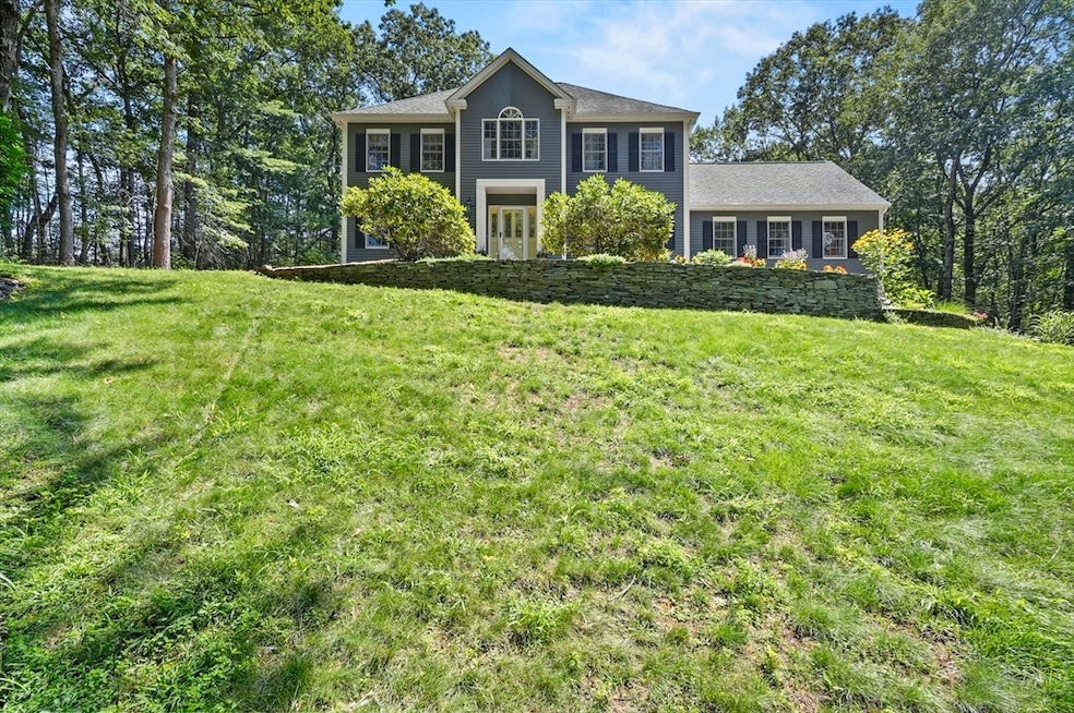
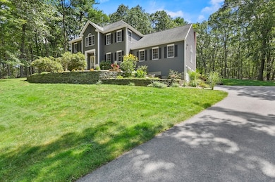
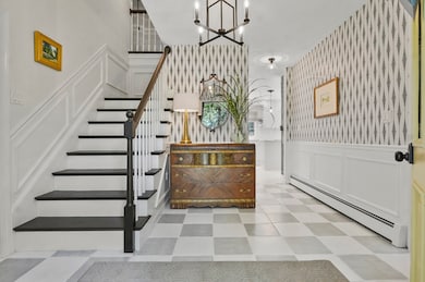
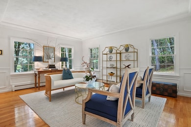
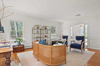
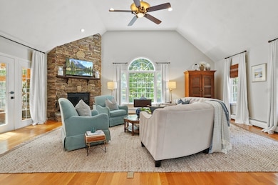
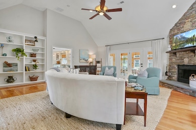
Welcome to Georgetown! Tucked away on a beautifully landscaped, private lot, this well-built and meticulously maintained home offers the perfect blend of comfort, quality, and character. From the moment you arrive, you'll appreciate the peace and seclusion—ideal for those who crave a quiet setting with room to unwind, entertain, and enjoy the outdoors. Inside, the home boasts spacious living areas filled with natural light, hardwood floors, and thoughtful updates throughout. The heart of the home flows effortlessly into a fully finished lower level that’s built for fun—complete with a custom bar and open party room that’s perfect for hosting game nights, celebrations, or simply relaxing with friends. Whether you're gathering indoors or enjoying the expansive yard and patio area, this home delivers the lifestyle you’ve been looking for. Pride of ownership shows in every detail—this is a property you won’t want to miss.
| Date | Type | Sale Price | Title Company |
|---|---|---|---|
| Quit Claim Deed | $1,149,000 | -- | |
| Quit Claim Deed | -- | -- | |
| Quit Claim Deed | -- | -- | |
| Quit Claim Deed | -- | -- | |
| Quit Claim Deed | -- | -- | |
| Quit Claim Deed | -- | -- | |
| Quit Claim Deed | -- | -- | |
| Quit Claim Deed | -- | -- | |
| Quit Claim Deed | -- | -- | |
| Quit Claim Deed | -- | -- | |
| Deed | -- | -- | |
| Deed | -- | -- | |
| Quit Claim Deed | -- | -- | |
| Quit Claim Deed | -- | -- | |
| Deed | -- | -- | |
| Deed | -- | -- | |
| Deed | $688,500 | -- | |
| Deed | $688,500 | -- | |
| Deed | $138,000 | -- | |
| Deed | $60,000 | -- | |
| Deed | $60,000 | -- |
| Date | Status | Loan Amount | Loan Type |
|---|---|---|---|
| Open | $1,024,000 | New Conventional | |
| Previous Owner | $220,000 | No Value Available | |
| Previous Owner | $200,000 | No Value Available |
| Date | Event | Price | List to Sale | Price per Sq Ft |
|---|---|---|---|---|
| 11/06/2025 11/06/25 | Sold | $1,149,000 | 0.0% | $291 / Sq Ft |
| 10/14/2025 10/14/25 | Pending | -- | -- | -- |
| 10/14/2025 10/14/25 | Price Changed | $1,149,000 | -2.5% | $291 / Sq Ft |
| 09/05/2025 09/05/25 | For Sale | $1,179,000 | 0.0% | $298 / Sq Ft |
| 08/22/2025 08/22/25 | Pending | -- | -- | -- |
| 08/13/2025 08/13/25 | For Sale | $1,179,000 | -- | $298 / Sq Ft |
| Year | Tax Paid | Tax Assessment Tax Assessment Total Assessment is a certain percentage of the fair market value that is determined by local assessors to be the total taxable value of land and additions on the property. | Land | Improvement |
|---|---|---|---|---|
| 2025 | $10,802 | $976,700 | $342,400 | $634,300 |
| 2024 | $10,924 | $870,400 | $238,300 | $632,100 |
| 2023 | $11,298 | $870,400 | $238,300 | $632,100 |
| 2022 | $11,091 | $787,700 | $208,000 | $579,700 |
| 2021 | $10,545 | $663,600 | $208,000 | $455,600 |
| 2020 | $10,565 | $663,600 | $208,000 | $455,600 |
| 2019 | $10,412 | $659,800 | $204,200 | $455,600 |
| 2018 | $10,043 | $632,400 | $204,200 | $428,200 |
| 2017 | $9,653 | $595,500 | $204,200 | $391,300 |
| 2016 | $9,320 | $587,300 | $204,200 | $383,100 |
| 2015 | $9,091 | $567,100 | $204,200 | $362,900 |
| 2014 | $7,968 | $567,100 | $204,200 | $362,900 |
Seller's Agent in 2025
Joyce Jackson
Lamacchia Realty, Inc.
3 in this area
5 Total Sales
A
Buyer's Agent in 2025
Angela Dowd
Keller Williams Gateway Realty
(888) 854-7493
1 in this area
25 Total Sales
Source: MLS Property Information Network (MLS PIN)
MLS Number: 73417194
APN: GEOR-000009-000000-000000-000006-H
Disclaimer: Certain information contained herein is derived from information provided by parties other than Homes.com. All information provided is deemed reliable, but is not guaranteed to be accurate and should be independently verified.
![]() The property listing data and information, or the Images, set forth herein were provided to MLS Property Information Network, Inc. from third party sources, including sellers, lessors and public records, and were compiled by MLS Property Information Network, Inc. The property listing data and information, and the Images, are for the personal, non-commercial use of consumers having a good faith interest in purchasing or leasing listed properties of the type displayed to them and may not be used for any purpose other than to identify prospective properties which such consumers may have a good faith interest in purchasing or leasing. MLS Property Information Network, Inc. and its subscribers disclaim any and all representations and warranties as to the accuracy of the property listing data and information, or as to the accuracy of any of the Images, set forth herein.
The property listing data and information, or the Images, set forth herein were provided to MLS Property Information Network, Inc. from third party sources, including sellers, lessors and public records, and were compiled by MLS Property Information Network, Inc. The property listing data and information, and the Images, are for the personal, non-commercial use of consumers having a good faith interest in purchasing or leasing listed properties of the type displayed to them and may not be used for any purpose other than to identify prospective properties which such consumers may have a good faith interest in purchasing or leasing. MLS Property Information Network, Inc. and its subscribers disclaim any and all representations and warranties as to the accuracy of the property listing data and information, or as to the accuracy of any of the Images, set forth herein.
Ask me questions while you tour the home.