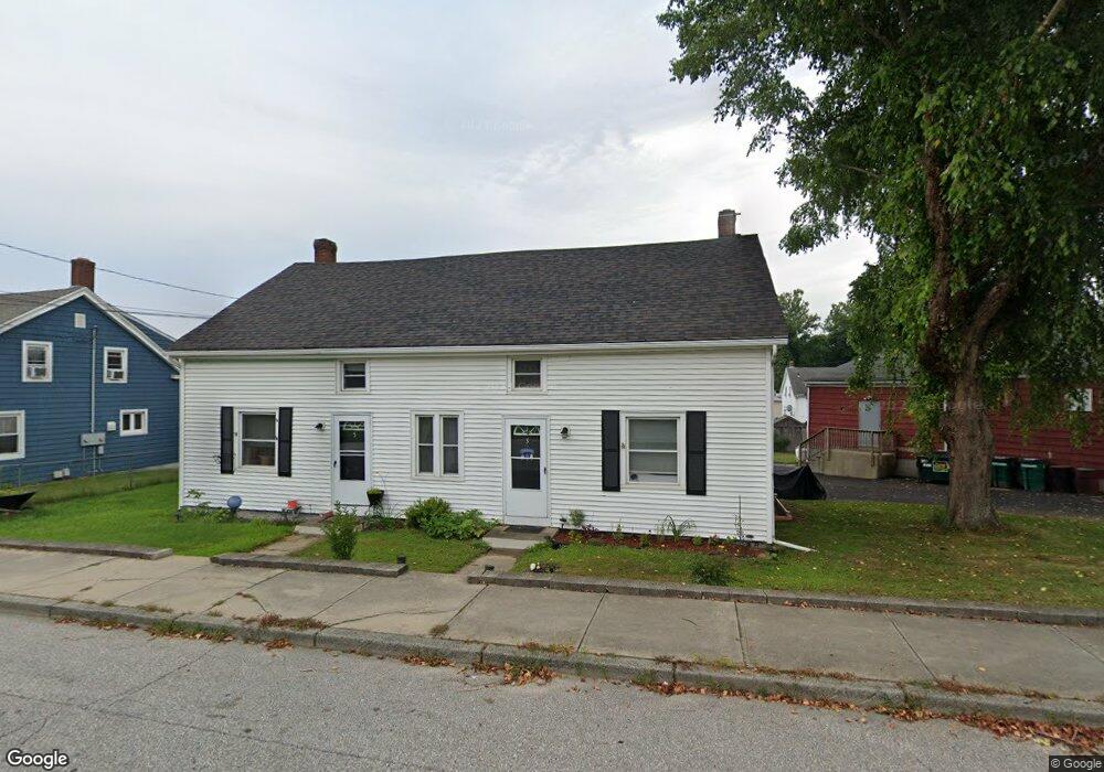
3 S Chestnut St Plainfield, CT 06374
Estimated Value: $122,536 - $353,000
6
Beds
2
Baths
2,361
Sq Ft
$117/Sq Ft
Est. Value
About This Home
This home is located at 3 S Chestnut St, Plainfield, CT 06374 and is currently estimated at $275,884, approximately $116 per square foot. 3 S Chestnut St is a home with nearby schools including Plainfield Memorial School, Plainfield Central Middle School, and Plainfield High School.
Ownership History
Date
Name
Owned For
Owner Type
Purchase Details
Closed on
Mar 20, 2019
Sold by
Dyson Kevin J and Dyson Jann E
Bought by
Kevin & Jann Dyson Irt
Current Estimated Value
Purchase Details
Closed on
Jan 13, 2015
Sold by
Deary Gene M and Deary Dawn
Bought by
Dyson Jann E and Dyson Kevin J
Purchase Details
Closed on
Nov 30, 2010
Sold by
Deary Gene Michael
Bought by
Deary Gene Michael and Deary Dawn
Create a Home Valuation Report for This Property
The Home Valuation Report is an in-depth analysis detailing your home's value as well as a comparison with similar homes in the area
Home Values in the Area
Average Home Value in this Area
Purchase History
| Date | Buyer | Sale Price | Title Company |
|---|---|---|---|
| Kevin & Jann Dyson Irt | -- | None Available | |
| Kevin & Jann Dyson Irt | -- | None Available | |
| Dyson Jann E | $65,000 | -- | |
| Dyson Jann E | $65,000 | -- | |
| Deary Gene Michael | -- | -- | |
| Deary Gene Michael | -- | -- |
Source: Public Records
Mortgage History
| Date | Status | Borrower | Loan Amount |
|---|---|---|---|
| Previous Owner | Deary Gene Michael | $101,800 |
Source: Public Records
Tax History
| Year | Tax Paid | Tax Assessment Tax Assessment Total Assessment is a certain percentage of the fair market value that is determined by local assessors to be the total taxable value of land and additions on the property. | Land | Improvement |
|---|---|---|---|---|
| 2025 | $2,814 | $117,920 | $25,340 | $92,580 |
| 2024 | $2,759 | $117,920 | $25,340 | $92,580 |
| 2023 | $2,687 | $117,920 | $25,340 | $92,580 |
| 2022 | $3,506 | $84,300 | $23,010 | $61,290 |
| 2021 | $2,582 | $84,300 | $23,010 | $61,290 |
| 2020 | $2,582 | $84,300 | $23,010 | $61,290 |
| 2019 | $2,582 | $84,300 | $23,010 | $61,290 |
| 2018 | $2,551 | $84,300 | $23,010 | $61,290 |
| 2017 | $2,752 | $85,410 | $24,360 | $61,050 |
| 2016 | $2,678 | $85,410 | $24,360 | $61,050 |
| 2015 | $2,585 | $84,320 | $24,360 | $59,960 |
| 2014 | $2,585 | $84,320 | $24,360 | $59,960 |
Source: Public Records
Map
Nearby Homes
- 30 S Walnut St
- 44-46 S Chestnut St
- 41 Grove St Unit 45
- 0 Wauregan Rd NE Unit 24143170
- 77 Charlotte Dr
- 263 Christian Hill Rd
- 14 Jolley Rd
- 193 Christian Hill Rd
- 33 Junior Ave
- 277 Moosup Pond Rd
- 8 Juniper Ln
- 561 Allen Hill Rd
- 0 Putnam Rd Unit 24147722
- 275 Moosup Pond Rd
- 30 Main St
- 10 School Street Extension
- 47 Texas Heights Rd
- 100 Squaw Rock Rd
- 76 Wauregan Rd
- 247 Green Hollow Rd
- 24-26 S Walnut St
- 18-20 S Walnut St
- TBD Atwood Ln
- NA Na
- 49-55 N Chestnut St
- 24 S Walnut St
- 18-20-20 S Walnut St Unit 20
- 34 S Walnut St Unit 34
- 2-14 S Walnut St
- 43-45 Wauregan Rd
- 2 S Walnut St
- 23 S Walnut St
- 17 S Walnut St
- 27 S Chestnut St
- 19 S Walnut St
- 8 N Chestnut St
- 18-20 N Chestnut St
- 66 Wauregan Road Plainfield Ct Rd
- 66 Wauregan Rd
Your Personal Tour Guide
Ask me questions while you tour the home.