Estimated Value: $666,379 - $852,000
3
Beds
2
Baths
1,500
Sq Ft
$479/Sq Ft
Est. Value
About This Home
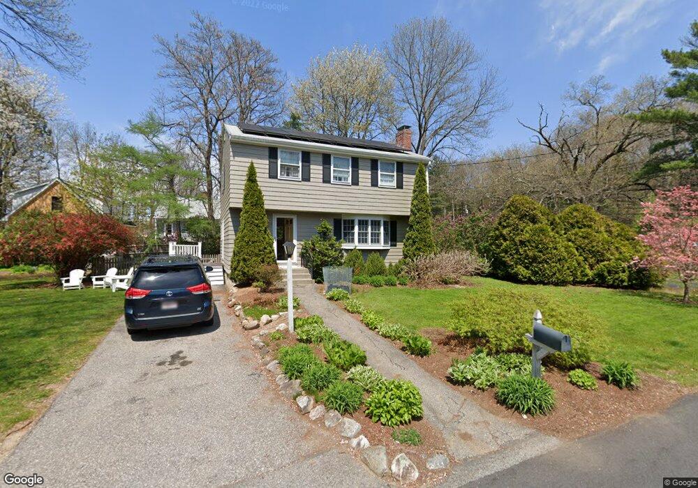
This home is located at 3 Sylvia St, Acton, MA 01720 and is currently estimated at $719,095, approximately $479 per square foot. 3 Sylvia St is a home located in Middlesex County with nearby schools including Acton-Boxborough Regional High School, Maynard Knowledge Beginnings, and The Imago School.
Ownership History
Date
Name
Owned For
Owner Type
Purchase Details
Closed on
Jul 29, 1999
Sold by
Witty Michael and Witty Cheryl K
Bought by
Martineau Janice C and Martineau Joseph E
Current Estimated Value
Purchase Details
Closed on
Nov 14, 1994
Sold by
Osullivan Richard C and Osullivan Catherine M
Bought by
Witty Michael and Witty Cheryl K
Purchase Details
Closed on
Nov 29, 1989
Sold by
Maki Paul A
Bought by
Osullivan Richard
Create a Home Valuation Report for This Property
The Home Valuation Report is an in-depth analysis detailing your home's value as well as a comparison with similar homes in the area
Home Values in the Area
Average Home Value in this Area
Purchase History
| Date | Buyer | Sale Price | Title Company |
|---|---|---|---|
| Martineau Janice C | $259,000 | -- | |
| Witty Michael | $201,500 | -- | |
| Osullivan Richard | $184,000 | -- |
Source: Public Records
Mortgage History
| Date | Status | Borrower | Loan Amount |
|---|---|---|---|
| Open | Osullivan Richard | $228,000 | |
| Closed | Osullivan Richard | $225,000 | |
| Closed | Osullivan Richard | $250,000 |
Source: Public Records
Tax History
| Year | Tax Paid | Tax Assessment Tax Assessment Total Assessment is a certain percentage of the fair market value that is determined by local assessors to be the total taxable value of land and additions on the property. | Land | Improvement |
|---|---|---|---|---|
| 2025 | $9,601 | $559,800 | $272,600 | $287,200 |
| 2024 | $9,165 | $549,800 | $272,600 | $277,200 |
| 2023 | $8,910 | $507,400 | $247,700 | $259,700 |
| 2022 | $8,447 | $434,300 | $215,300 | $219,000 |
| 2021 | $8,228 | $406,700 | $199,300 | $207,400 |
| 2020 | $7,638 | $397,000 | $199,300 | $197,700 |
| 2019 | $7,266 | $375,100 | $199,300 | $175,800 |
| 2018 | $7,161 | $369,500 | $199,300 | $170,200 |
| 2017 | $6,991 | $366,800 | $199,300 | $167,500 |
| 2016 | $6,894 | $358,500 | $199,300 | $159,200 |
| 2015 | $6,776 | $355,700 | $199,300 | $156,400 |
| 2014 | $6,704 | $344,700 | $199,300 | $145,400 |
Source: Public Records
Map
Nearby Homes
- 40 High St
- 131 Main St
- 129 Main St Unit 129
- 63 Conant St
- 30 Brewster Ln
- 25 Nylander Way
- 70 River St
- 6 Beacon Ct
- 1 Vanderbelt Rd
- 184 Main St Unit 3
- 36 Brown St
- 1 Carlton Dr
- 12 Brown St
- 7 Hillcrest Dr
- 130 Parker St Unit J2
- 1 Drummer Rd Unit A5
- 31 Drummer Rd Unit 31
- 7 Kelley Rd
- 6 Nancy Cir
- 70 Powder Mill Rd
Your Personal Tour Guide
Ask me questions while you tour the home.