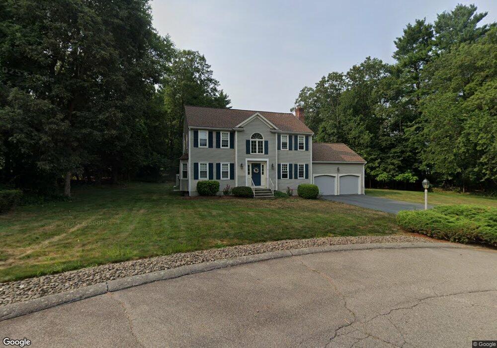
3 Thunder Hill Rd Medway, MA 02053
Estimated Value: $668,287 - $884,000
3
Beds
3
Baths
2,001
Sq Ft
$370/Sq Ft
Est. Value
About This Home
This home is located at 3 Thunder Hill Rd, Medway, MA 02053 and is currently estimated at $740,822, approximately $370 per square foot. 3 Thunder Hill Rd is a home located in Norfolk County with nearby schools including John D. McGovern Elementary School, Burke-Memorial Elementary, and Medway Middle School.
Ownership History
Date
Name
Owned For
Owner Type
Purchase Details
Closed on
Sep 23, 2022
Sold by
Mcconville Matthew J and Mcconville Brenda L
Bought by
Mcconville Brenda L
Current Estimated Value
Purchase Details
Closed on
Jan 17, 1991
Sold by
Toth John and Toth Kathleen
Bought by
Mcconville Matthew J and Mcconville Brenda L
Purchase Details
Closed on
Dec 27, 1990
Sold by
Totl John
Bought by
Mcconville Matthew W
Create a Home Valuation Report for This Property
The Home Valuation Report is an in-depth analysis detailing your home's value as well as a comparison with similar homes in the area
Home Values in the Area
Average Home Value in this Area
Purchase History
| Date | Buyer | Sale Price | Title Company |
|---|---|---|---|
| Mcconville Brenda L | -- | None Available | |
| Mcconville Matthew J | $199,000 | -- | |
| Mcconville Matthew W | $199,000 | -- |
Source: Public Records
Mortgage History
| Date | Status | Borrower | Loan Amount |
|---|---|---|---|
| Previous Owner | Mcconville Matthew W | $222,000 | |
| Previous Owner | Mcconville Matthew W | $25,000 | |
| Previous Owner | Mcconville Matthew W | $201,500 |
Source: Public Records
Tax History
| Year | Tax Paid | Tax Assessment Tax Assessment Total Assessment is a certain percentage of the fair market value that is determined by local assessors to be the total taxable value of land and additions on the property. | Land | Improvement |
|---|---|---|---|---|
| 2025 | $8,603 | $603,700 | $290,800 | $312,900 |
| 2024 | $8,693 | $603,700 | $290,800 | $312,900 |
| 2023 | $8,193 | $514,000 | $240,900 | $273,100 |
| 2022 | $7,969 | $470,700 | $213,900 | $256,800 |
| 2021 | $7,873 | $450,900 | $197,300 | $253,600 |
| 2020 | $7,467 | $426,700 | $182,800 | $243,900 |
| 2019 | $7,187 | $423,500 | $182,800 | $240,700 |
| 2018 | $6,933 | $392,600 | $157,800 | $234,800 |
| 2017 | $6,966 | $388,700 | $157,800 | $230,900 |
| 2016 | $6,440 | $355,600 | $130,000 | $225,600 |
| 2015 | $6,280 | $344,300 | $122,500 | $221,800 |
| 2014 | $6,539 | $347,100 | $128,800 | $218,300 |
Source: Public Records
Map
Nearby Homes
- 50 Main St
- 33 Gorwin Dr
- 58 Holliston St
- 20 Broad St Unit 1
- 20 Broad St Unit A
- 20 Broad St Unit 4
- 79 Lovering St Unit B
- 13 Teresa Dr
- 14 Teresa Dr
- 19 Evergreen St Unit A
- 5 Richardson St
- 8 Winthrop St
- 11 Fairway Ln
- 19 Sycamore Way
- 17 Fairway Ln
- 40 Timber Crest Dr
- 33 Spencer St
- 4 Shaw St
- 26 Timber Crest Dr
- 10 April Way
- 12 Lee Ln
- 10 Lee Ln
- 42 Coffee St
- 30 Main St
- 44 Coffee St
- 4 Thunder Hill Rd Unit B
- 4 Thunder Hill Rd Unit A
- 40 Coffee St
- 8 Lee Ln
- 46 Coffee St
- 1 Thunder Hill Rd Unit B
- 1 Thunder Hill Rd Unit A
- 1-B Thunder Hill Rd Unit B
- 1-B Thunder Hill Rd
- 6 Lee Ln
- 2 Thunder Hill Rd
- 11 Lee Ln
- 38 Coffee St
- 1B Thunder Hill Rd Unit B
- 1B Thunder Hill Rd
Your Personal Tour Guide
Ask me questions while you tour the home.