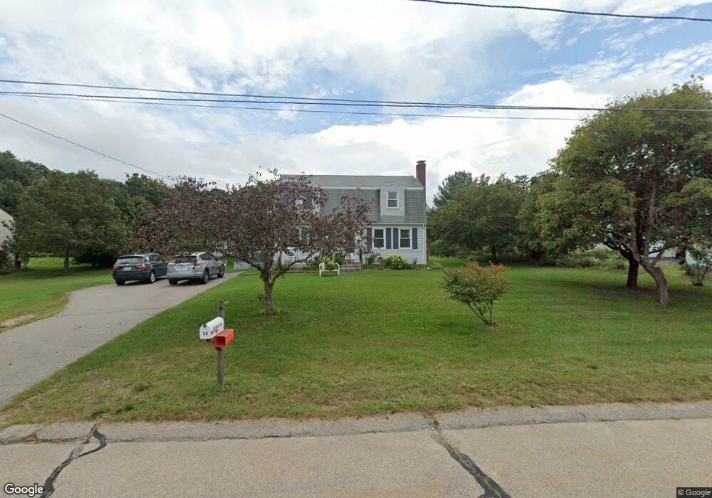
30 Aldis Ln Wrentham, MA 02093
Estimated Value: $591,000 - $669,000
4
Beds
2
Baths
1,632
Sq Ft
$380/Sq Ft
Est. Value
About This Home
This home is located at 30 Aldis Ln, Wrentham, MA 02093 and is currently estimated at $620,650, approximately $380 per square foot. 30 Aldis Ln is a home located in Norfolk County with nearby schools including Delaney Elementary School and Charles E Roderick.
Ownership History
Date
Name
Owned For
Owner Type
Purchase Details
Closed on
Sep 27, 2022
Sold by
Mannering Robert and Mannering Nancy K
Bought by
Mannering Ft
Current Estimated Value
Purchase Details
Closed on
Jul 2, 1986
Bought by
Mannering Robert and Mannering Nancy K
Create a Home Valuation Report for This Property
The Home Valuation Report is an in-depth analysis detailing your home's value as well as a comparison with similar homes in the area
Purchase History
| Date | Buyer | Sale Price | Title Company |
|---|---|---|---|
| Mannering Ft | -- | None Available | |
| Mannering Robert | -- | -- |
Source: Public Records
Mortgage History
| Date | Status | Borrower | Loan Amount |
|---|---|---|---|
| Previous Owner | Mannering Robert | $80,000 | |
| Previous Owner | Mannering Robert | $80,000 |
Source: Public Records
Tax History
| Year | Tax Paid | Tax Assessment Tax Assessment Total Assessment is a certain percentage of the fair market value that is determined by local assessors to be the total taxable value of land and additions on the property. | Land | Improvement |
|---|---|---|---|---|
| 2025 | $6,146 | $530,300 | $289,500 | $240,800 |
| 2024 | $5,933 | $494,400 | $289,500 | $204,900 |
| 2023 | $5,751 | $455,700 | $263,300 | $192,400 |
| 2022 | $5,612 | $410,500 | $245,700 | $164,800 |
| 2021 | $5,296 | $376,400 | $214,400 | $162,000 |
| 2020 | $5,163 | $362,300 | $190,700 | $171,600 |
| 2019 | $5,116 | $362,300 | $190,700 | $171,600 |
| 2018 | $4,805 | $337,400 | $190,900 | $146,500 |
| 2017 | $4,561 | $320,100 | $187,200 | $132,900 |
| 2016 | $4,375 | $306,400 | $181,800 | $124,600 |
| 2015 | $4,259 | $284,300 | $174,700 | $109,600 |
| 2014 | $4,209 | $274,900 | $168,100 | $106,800 |
Source: Public Records
Map
Nearby Homes
- 246 Forest Grove Ave
- 287 Park St
- 500 Franklin St
- 45 Joshua Rd
- 50 Reed Fulton Ave Unit Lot 61
- 10 Nature View Dr
- 15 Nature View Dr
- 0 W Birch Rd
- 8 Ridgefield Rd
- 11 Weber Farm Rd Unit 11
- 8 Weber Farm Rd Unit 8
- 576 Dedham St
- 30 Weber Farm Rd Unit 30
- 11 Sharon Ave
- 9 Sharon Ave
- 2 Earle Stewart Ln
- 3 Earle Stewart Ln
- 12 Earle Stewart Ln
- 10 Earle Stewart Ln Unit Lot 5
- 23 Fredrickson Rd
Your Personal Tour Guide
Ask me questions while you tour the home.