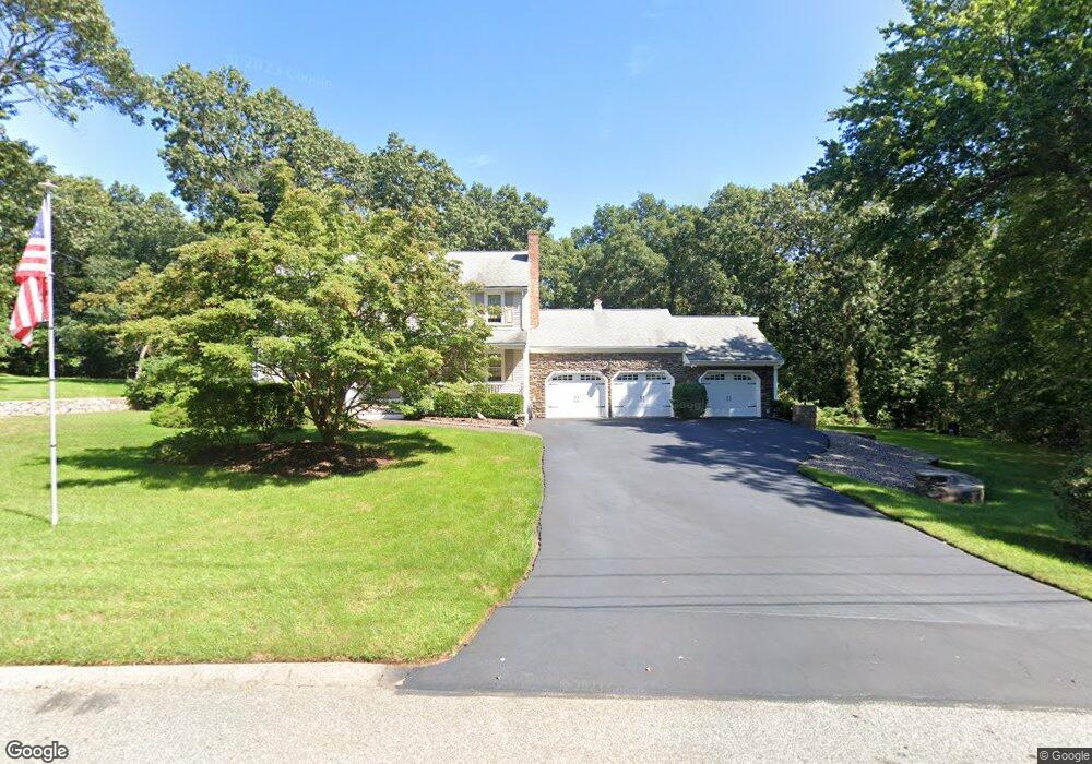
30 Arrowhead Rd Wrentham, MA 02093
Estimated Value: $661,000 - $799,000
4
Beds
3
Baths
2,240
Sq Ft
$328/Sq Ft
Est. Value
About This Home
This home is located at 30 Arrowhead Rd, Wrentham, MA 02093 and is currently estimated at $735,067, approximately $328 per square foot. 30 Arrowhead Rd is a home located in Norfolk County with nearby schools including Delaney Elementary School, Charles E Roderick, and Discovery Daycare Center.
Ownership History
Date
Name
Owned For
Owner Type
Purchase Details
Closed on
Aug 17, 1987
Sold by
Joel Constr Inc
Bought by
Costa Edwaard F
Current Estimated Value
Create a Home Valuation Report for This Property
The Home Valuation Report is an in-depth analysis detailing your home's value as well as a comparison with similar homes in the area
Purchase History
| Date | Buyer | Sale Price | Title Company |
|---|---|---|---|
| Costa Edwaard F | $249,900 | -- |
Source: Public Records
Mortgage History
| Date | Status | Borrower | Loan Amount |
|---|---|---|---|
| Open | Costa Edwaard F | $274,000 | |
| Closed | Costa Edwaard F | $100,000 | |
| Closed | Costa Edwaard F | $133,500 |
Source: Public Records
Tax History
| Year | Tax Paid | Tax Assessment Tax Assessment Total Assessment is a certain percentage of the fair market value that is determined by local assessors to be the total taxable value of land and additions on the property. | Land | Improvement |
|---|---|---|---|---|
| 2025 | $7,421 | $640,300 | $274,300 | $366,000 |
| 2024 | $7,213 | $601,100 | $274,300 | $326,800 |
| 2023 | $7,133 | $565,200 | $249,400 | $315,800 |
| 2022 | $6,711 | $490,900 | $224,500 | $266,400 |
| 2021 | $6,274 | $445,900 | $200,700 | $245,200 |
| 2020 | $6,410 | $449,800 | $183,200 | $266,600 |
| 2019 | $6,180 | $437,700 | $183,200 | $254,500 |
| 2018 | $7,076 | $496,900 | $183,400 | $313,500 |
| 2017 | $6,883 | $483,000 | $179,800 | $303,200 |
| 2016 | $6,739 | $471,900 | $174,600 | $297,300 |
| 2015 | $6,760 | $451,300 | $167,900 | $283,400 |
| 2014 | $6,651 | $434,400 | $161,500 | $272,900 |
Source: Public Records
Map
Nearby Homes
- 483 Thurston St
- 282 Thurston St
- 10 Nature View Dr
- 15 Nature View Dr
- 46 Mirimichi St
- 3 Earle Stewart Ln
- 16 Treasure Island Rd
- 10 Earle Stewart Ln Unit Lot 5
- 2 Earle Stewart Ln
- 12 Earle Stewart Ln
- 160 Washington St Unit 22
- 40 Treasure Island Rd
- 135 Creek St Unit 2
- 126 Washington St
- 130 Washington St
- 124 Washington St
- 158 Washington St
- 8 Conway Ln
- 131 Washington St Unit 42
- 131 Washington St Unit 50
- 40 Arrowhead Rd
- 40 Arrowhead Rd Unit 40
- 20 Arrowhead Rd
- 50 Arrowhead Rd
- 55 Arrowhead Rd
- 10 Arrowhead Rd
- 65 Arrowhead Rd
- 130 Hawes St
- 140 Hawes St
- 100 Hawes St
- 75 Arrowhead Rd
- 150 Hawes St
- 15 Arrowhead Rd
- 105 Hawes St
- 5 Arrowhead Rd
- 60 Arrowhead Rd
- 90 Hawes St
- 25 Arrowhead Rd
- 115 Hawes St
- 25 Indian Head Rd
Your Personal Tour Guide
Ask me questions while you tour the home.