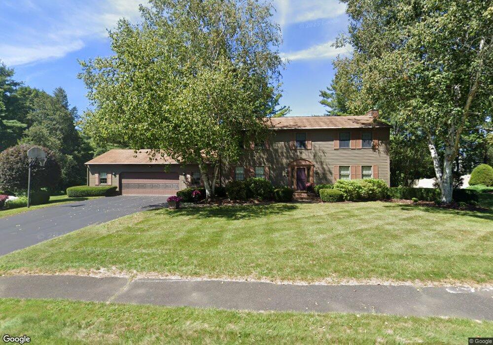
30 Brookside Dr Pittsfield, MA 01201
Estimated Value: $565,000 - $622,000
4
Beds
3
Baths
2,704
Sq Ft
$220/Sq Ft
Est. Value
About This Home
This home is located at 30 Brookside Dr, Pittsfield, MA 01201 and is currently estimated at $594,336, approximately $219 per square foot. 30 Brookside Dr is a home located in Berkshire County with nearby schools including Williams Elementary School, Theodore Herberg Middle School, and Pittsfield High School.
Ownership History
Date
Name
Owned For
Owner Type
Purchase Details
Closed on
Jan 3, 2012
Sold by
Desgroseilliers Joyce M and Desgroseilliers Ronald F
Bought by
Rf and Jm Desgroseilliers
Current Estimated Value
Purchase Details
Closed on
Apr 4, 1980
Bought by
R F T and J M Desgroseilleirs T
Create a Home Valuation Report for This Property
The Home Valuation Report is an in-depth analysis detailing your home's value as well as a comparison with similar homes in the area
Home Values in the Area
Average Home Value in this Area
Purchase History
| Date | Buyer | Sale Price | Title Company |
|---|---|---|---|
| Rf | -- | -- | |
| Rf | -- | -- | |
| Rf | -- | -- | |
| R F T | $101,000 | -- |
Source: Public Records
Mortgage History
| Date | Status | Borrower | Loan Amount |
|---|---|---|---|
| Previous Owner | R F T | $86,000 |
Source: Public Records
Tax History
| Year | Tax Paid | Tax Assessment Tax Assessment Total Assessment is a certain percentage of the fair market value that is determined by local assessors to be the total taxable value of land and additions on the property. | Land | Improvement |
|---|---|---|---|---|
| 2025 | $10,281 | $573,100 | $73,600 | $499,500 |
| 2024 | $9,280 | $503,000 | $73,600 | $429,400 |
| 2023 | $8,504 | $464,200 | $73,600 | $390,600 |
| 2022 | $7,671 | $413,300 | $73,600 | $339,700 |
| 2021 | $7,457 | $387,400 | $73,600 | $313,800 |
| 2020 | $7,423 | $376,600 | $73,600 | $303,000 |
| 2019 | $7,123 | $366,800 | $73,600 | $293,200 |
| 2018 | $7,024 | $351,000 | $68,600 | $282,400 |
| 2017 | $6,778 | $345,300 | $73,600 | $271,700 |
| 2016 | $6,624 | $353,100 | $73,600 | $279,500 |
| 2015 | $6,377 | $353,100 | $73,600 | $279,500 |
Source: Public Records
Map
Nearby Homes
- 26 Brookside Dr
- 4 Filomena Dr
- 28 Jayne Ave
- 461 Elm St
- 104 Washington Mountain Rd
- 100 Elaine Dr
- 161 Leona Dr
- 31 Eric Dr
- 10 Marlboro Dr
- 612 E New Lenox Rd
- 51 Foote Ave
- 17 Kenwood St
- 121 Edward Ave
- 39 Lexington Pkwy
- 0 Dalton Division Rd
- 43 Palomino Dr
- 57 Palomino Dr
- 67 Reuter Ave
- 50 Grand Ave
- 889 Holmes Rd
- 28 Brookside Dr
- 91 Stonehenge Rd
- 29 Brookside Dr
- 33 Brookside Dr
- 81 Stonehenge Rd
- 27 Brookside Dr
- 34 Brookside Dr
- 132 Alfred Dr
- 140 Alfred Dr
- 124 Alfred Dr
- 116 Alfred Dr
- 148 Alfred Dr
- 36 Brookside Dr
- 25 Brookside Dr
- 90 Stonehenge Rd
- 108 Alfred Dr
- 24 Brookside Dr
- 38 Brookside Dr
- 80 Stonehenge Rd
- 100 Alfred Dr