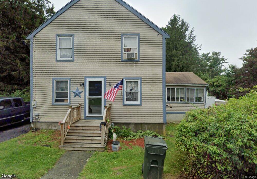
30 Crane Ave Westport, MA 02790
North Westport NeighborhoodEstimated Value: $422,000 - $546,000
3
Beds
2
Baths
1,536
Sq Ft
$316/Sq Ft
Est. Value
About This Home
This home is located at 30 Crane Ave, Westport, MA 02790 and is currently estimated at $485,100, approximately $315 per square foot. 30 Crane Ave is a home located in Bristol County with nearby schools including Alice A. Macomber Primary School, Westport Elementary School, and Espirito Santo Parochial School.
Ownership History
Date
Name
Owned For
Owner Type
Purchase Details
Closed on
Mar 17, 1997
Sold by
Grillo Robert and Grillo Lisa
Bought by
Moniz Rhonda L and Moniz Kenneth V
Current Estimated Value
Purchase Details
Closed on
Jan 4, 1990
Sold by
Dyson Alford
Bought by
Grillo Robert
Create a Home Valuation Report for This Property
The Home Valuation Report is an in-depth analysis detailing your home's value as well as a comparison with similar homes in the area
Home Values in the Area
Average Home Value in this Area
Purchase History
| Date | Buyer | Sale Price | Title Company |
|---|---|---|---|
| Moniz Rhonda L | $125,000 | -- | |
| Grillo Robert | $101,300 | -- |
Source: Public Records
Mortgage History
| Date | Status | Borrower | Loan Amount |
|---|---|---|---|
| Open | Grillo Robert | $177,313 | |
| Closed | Grillo Robert | $185,795 | |
| Closed | Grillo Robert | $65,000 |
Source: Public Records
Tax History Compared to Growth
Tax History
| Year | Tax Paid | Tax Assessment Tax Assessment Total Assessment is a certain percentage of the fair market value that is determined by local assessors to be the total taxable value of land and additions on the property. | Land | Improvement |
|---|---|---|---|---|
| 2025 | $2,502 | $335,800 | $143,900 | $191,900 |
| 2024 | $2,492 | $322,400 | $133,300 | $189,100 |
| 2023 | $2,404 | $294,600 | $120,900 | $173,700 |
| 2022 | $2,219 | $267,900 | $114,900 | $153,000 |
| 2021 | $2,926 | $257,400 | $104,400 | $153,000 |
| 2020 | $2,091 | $248,000 | $95,000 | $153,000 |
| 2019 | $1,933 | $233,700 | $95,000 | $138,700 |
| 2018 | $1,821 | $206,100 | $82,000 | $124,100 |
| 2017 | $1,997 | $208,800 | $87,600 | $121,200 |
| 2016 | $1,616 | $204,300 | $83,100 | $121,200 |
| 2015 | $1,576 | $198,700 | $95,500 | $103,200 |
Source: Public Records
Map
Nearby Homes
- 16 S Berryman St
- 15 S Breault St
- 79 Center St
- 380 Gifford Rd
- 565 Highland Ave
- 116 Gifford Rd
- 29 Union Ave
- 23 Donna St
- 56 Lakeside Ave
- 55 Lakeside Ave
- 735 Reed Rd
- 3 Roller Coaster Way Unit Lot 1
- 818 Reed Rd
- 1276 Old Fall River Rd
- 100 D Dr
- 461 Reed Rd
- 2 Donna Marie Dr
- 3 Diane Way
- 1174 Old Fall River Rd
- 4 Main Rd
- o Russell and Crane St
- 29 Crane Ave
- 24 Crane Ave
- 30 Russell St
- 41 Oakland St
- 26 S Berryman St
- 18 S Berryman St
- 30 S Berryman St
- 36 Crane Ave
- 26 Russell St
- 27 S Berryman St
- 15 S Berryman St
- 42 Oakland St
- 12 S Berryman St
- 33 S Berryman St
- 33 S Berryman St
- 12 S Breault St
- 18 S Breault St
- 13 Crane Ave
- 18 Russell St