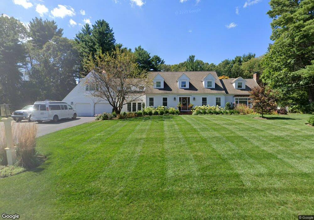
30 Cushing Hill Rd Hanover, MA 02339
Estimated Value: $1,155,000 - $1,725,000
4
Beds
3
Baths
3,286
Sq Ft
$408/Sq Ft
Est. Value
About This Home
This home is located at 30 Cushing Hill Rd, Hanover, MA 02339 and is currently estimated at $1,341,949, approximately $408 per square foot. 30 Cushing Hill Rd is a home located in Plymouth County with nearby schools including Hanover High School, South Shore Charter Public School, and Norwell KinderCare.
Ownership History
Date
Name
Owned For
Owner Type
Purchase Details
Closed on
Jun 13, 2013
Sold by
Ceurvels Timothy A
Bought by
Ceurvels Timothy A and Ceurvels Courtney M
Current Estimated Value
Purchase Details
Closed on
Aug 12, 2010
Sold by
Mary B Judge T
Bought by
Ceurvels Timothy A and Ceurvels Courtney M
Home Financials for this Owner
Home Financials are based on the most recent Mortgage that was taken out on this home.
Original Mortgage
$307,000
Interest Rate
4.63%
Mortgage Type
Purchase Money Mortgage
Purchase Details
Closed on
Apr 12, 2004
Sold by
Judge Mary B and Judge James J
Bought by
Mary B Judge T
Purchase Details
Closed on
Jul 29, 1992
Sold by
Tedeschi Mary A and Tedeschi Jan M
Bought by
Judge James J and Judge Mary B
Create a Home Valuation Report for This Property
The Home Valuation Report is an in-depth analysis detailing your home's value as well as a comparison with similar homes in the area
Home Values in the Area
Average Home Value in this Area
Purchase History
We collect this data history from publicly available records. To have your information removed, we recommend requesting removal directly through your county’s website.
| Date | Buyer | Sale Price | Title Company |
|---|---|---|---|
| Ceurvels Timothy A | -- | -- | |
| Ceurvels Timothy A | -- | -- | |
| Ceurvels Timothy A | $700,000 | -- | |
| Mary B Judge T | -- | -- | |
| Judge James J | $316,000 | -- |
Source: Public Records
Mortgage History
We collect this data history from publicly available records. To have your information removed, we recommend requesting removal directly through your county’s website.
| Date | Status | Borrower | Loan Amount |
|---|---|---|---|
| Previous Owner | Ceurvels Timothy A | $307,000 | |
| Previous Owner | Judge James J | $240,000 | |
| Previous Owner | Judge James J | $408,500 |
Source: Public Records
Tax History
| Year | Tax Paid | Tax Assessment Tax Assessment Total Assessment is a certain percentage of the fair market value that is determined by local assessors to be the total taxable value of land and additions on the property. | Land | Improvement |
|---|---|---|---|---|
| 2025 | $13,328 | $1,079,200 | $352,300 | $726,900 |
| 2024 | $12,826 | $998,900 | $352,300 | $646,600 |
| 2023 | $13,344 | $989,200 | $320,700 | $668,500 |
| 2022 | $13,736 | $900,700 | $282,500 | $618,200 |
| 2021 | $14,065 | $861,300 | $257,100 | $604,200 |
| 2020 | $13,880 | $851,000 | $257,100 | $593,900 |
| 2019 | $13,077 | $796,900 | $280,300 | $516,600 |
| 2018 | $12,812 | $787,000 | $280,300 | $506,700 |
| 2017 | $11,604 | $702,400 | $280,200 | $422,200 |
| 2016 | $11,579 | $686,800 | $254,900 | $431,900 |
| 2015 | $10,780 | $667,500 | $254,900 | $412,600 |
Source: Public Records
Map
Nearby Homes
- 283 Pond St
- 392 Cedar St
- 491 Webster St
- 569 Main St
- 107 Pond St
- 239 Washington St Unit 20
- 214 Washington St Unit 28
- 11 Duncan Dr
- 20 Jackson Rd
- 9 Douglas Ave
- 18 W End Way Unit 18W
- 15 Leigh Rd
- 313 E Water St
- 17 Sunnybank Ave
- 10 Sunnybank Ave
- 92-94 Stanton St
- 173 Liberty St
- 286 Mayflower Cir
- 823 Market St
- 196 Myrtle St
- 25 Cushing Hill Rd
- 793 Webster St
- 15 Cushing Hill Rd
- 799 Webster St
- 39 Cushing Hill Rd
- 46 Cushing Hill Rd
- 813 Webster St
- 47 Cushing Hill Rd
- 790 Webster St
- 780 Webster St
- 753 Webster St
- 747 Webster St
- 764 Webster St
- 60 Cushing Hill Rd
- 63 Cushing Hill Rd
- 808 Webster St
- 821 Webster St
- 38 Damon Rd
- 164 Brookwood Rd
- 824 Webster St
Your Personal Tour Guide
Ask me questions while you tour the home.