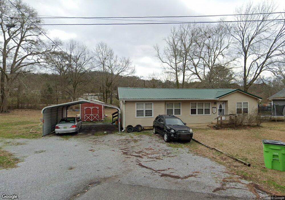
30 Dorthy Dr Springville, AL 35146
Estimated Value: $124,000 - $240,000
--
Bed
--
Bath
1,261
Sq Ft
$141/Sq Ft
Est. Value
About This Home
This home is located at 30 Dorthy Dr, Springville, AL 35146 and is currently estimated at $177,571, approximately $140 per square foot. 30 Dorthy Dr is a home with nearby schools including Springville Elementary School, Springville Middle School, and Springville High School.
Ownership History
Date
Name
Owned For
Owner Type
Purchase Details
Closed on
Mar 2, 2021
Sold by
Vickery Kathy
Bought by
Metro Bank
Current Estimated Value
Purchase Details
Closed on
Apr 12, 2006
Sold by
Spence John
Bought by
Vickery Kathy
Home Financials for this Owner
Home Financials are based on the most recent Mortgage that was taken out on this home.
Original Mortgage
$51,485
Interest Rate
6.29%
Mortgage Type
Purchase Money Mortgage
Purchase Details
Closed on
Feb 3, 2005
Sold by
Windham Lewis R
Bought by
Spence John
Home Financials for this Owner
Home Financials are based on the most recent Mortgage that was taken out on this home.
Original Mortgage
$10,256
Interest Rate
5.66%
Mortgage Type
Purchase Money Mortgage
Create a Home Valuation Report for This Property
The Home Valuation Report is an in-depth analysis detailing your home's value as well as a comparison with similar homes in the area
Home Values in the Area
Average Home Value in this Area
Purchase History
| Date | Buyer | Sale Price | Title Company |
|---|---|---|---|
| Metro Bank | $67,735 | None Available | |
| Vickery Kathy | -- | None Available | |
| Spence John | -- | None Available |
Source: Public Records
Mortgage History
| Date | Status | Borrower | Loan Amount |
|---|---|---|---|
| Previous Owner | Vickery Kathy | $51,485 | |
| Previous Owner | Spence John | $10,256 |
Source: Public Records
Tax History Compared to Growth
Tax History
| Year | Tax Paid | Tax Assessment Tax Assessment Total Assessment is a certain percentage of the fair market value that is determined by local assessors to be the total taxable value of land and additions on the property. | Land | Improvement |
|---|---|---|---|---|
| 2024 | $584 | $22,912 | $6,000 | $16,912 |
| 2023 | $584 | $20,296 | $4,800 | $15,496 |
| 2022 | $365 | $20,296 | $4,800 | $15,496 |
| 2021 | $319 | $20,296 | $4,800 | $15,496 |
| 2020 | $319 | $17,708 | $4,800 | $12,908 |
| 2019 | $319 | $17,708 | $4,800 | $12,908 |
| 2018 | $268 | $7,440 | $0 | $0 |
| 2017 | $256 | $7,440 | $0 | $0 |
| 2016 | $259 | $7,200 | $0 | $0 |
| 2015 | $256 | $7,200 | $0 | $0 |
| 2014 | $256 | $7,120 | $0 | $0 |
Source: Public Records
Map
Nearby Homes
- 434 Mountain Dr
- 6178 Route 11
- 18 Wilson St
- 120 MacDonald Lake Rd
- 6559 Us Highway 11
- 428 MacDonald Lake Rd
- 325 Mcginnis St Unit LOT
- 351 Mcginnis St
- 282 Robinson St
- 251 Robinson St
- 0 Robinson St Unit 1
- 6371 Us Highway 11
- 973 MacDonald Lake Rd
- 112 Robinson St Unit 1
- 0 Highway 174 Unit 17746312
- 0 Highway 174 Unit Tract 3 21427180
- 0 Highway 174 Unit Tract 8 21415020
- 0 Hwy 174 Unit 17746313
- 0 Hwy 174 Unit 17746319
- 1247 Cross St
- 0 Dorothy Way Unit 17
- 0 Dorothy Way Unit 32
- 0 Dorothy Way Unit 31
- 0 Dorothy Way Unit 30
- 0 Dorothy Way Unit 29
- 0 Dorothy Way Unit 28
- 0 Dorothy Way Unit 27
- 0 Dorothy Way Unit 26
- 0 Dorothy Way Unit 25
- 0 Dorothy Way Unit 24
- 0 Dorothy Way Unit 23
- 0 Dorothy Way Unit 22
- 0 Dorothy Way Unit 21
- 0 Dorothy Way Unit 19
- 0 Dorothy Way Unit 18
- 0 Dorothy Way Unit 20
- 0 Dorothy Way Unit 40 501290
- 0 Dorothy Way Unit 39 501289
- 0 Dorothy Way Unit 38 501288
- 0 Dorothy Way Unit 37 501285