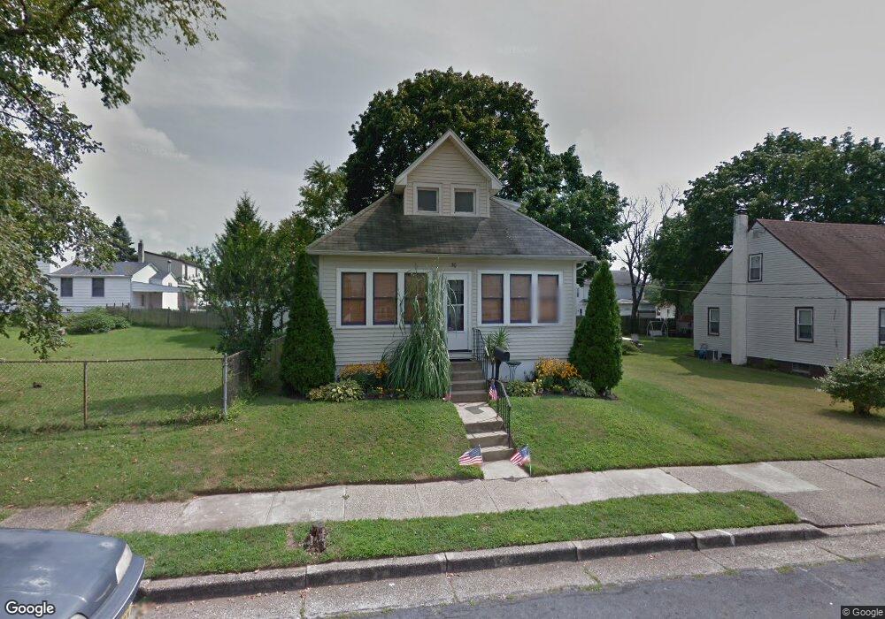
30 E 9th Ave Glendora, NJ 08029
Estimated Value: $249,000 - $283,691
Studio
--
Bath
1,252
Sq Ft
$216/Sq Ft
Est. Value
About This Home
This home is located at 30 E 9th Ave, Glendora, NJ 08029 and is currently estimated at $270,423, approximately $215 per square foot. 30 E 9th Ave is a home located in Camden County with nearby schools including Glen Landing Middle School, Triton High School, and St. Teresa Regional School.
Ownership History
Date
Name
Owned For
Owner Type
Purchase Details
Closed on
Apr 29, 2002
Sold by
Krauss David
Bought by
Hoppe Denise
Current Estimated Value
Home Financials for this Owner
Home Financials are based on the most recent Mortgage that was taken out on this home.
Original Mortgage
$100,424
Interest Rate
6.8%
Mortgage Type
FHA
Purchase Details
Closed on
Nov 21, 2001
Sold by
Gillen William A
Bought by
Krauss David
Create a Home Valuation Report for This Property
The Home Valuation Report is an in-depth analysis detailing your home's value as well as a comparison with similar homes in the area
Home Values in the Area
Average Home Value in this Area
Purchase History
| Date | Buyer | Sale Price | Title Company |
|---|---|---|---|
| Hoppe Denise | $102,000 | -- | |
| Krauss David | $50,000 | -- |
Source: Public Records
Mortgage History
| Date | Status | Borrower | Loan Amount |
|---|---|---|---|
| Previous Owner | Hoppe Denise | $100,424 |
Source: Public Records
Tax History
| Year | Tax Paid | Tax Assessment Tax Assessment Total Assessment is a certain percentage of the fair market value that is determined by local assessors to be the total taxable value of land and additions on the property. | Land | Improvement |
|---|---|---|---|---|
| 2025 | $6,149 | $145,500 | $47,200 | $98,300 |
| 2024 | $5,944 | $145,500 | $47,200 | $98,300 |
| 2023 | $5,944 | $145,500 | $47,200 | $98,300 |
| 2022 | $5,912 | $145,500 | $47,200 | $98,300 |
| 2021 | $5,547 | $145,500 | $47,200 | $98,300 |
| 2020 | $5,792 | $145,500 | $47,200 | $98,300 |
| 2019 | $5,664 | $145,500 | $47,200 | $98,300 |
| 2018 | $5,640 | $145,500 | $47,200 | $98,300 |
| 2017 | $6,571 | $145,500 | $47,200 | $98,300 |
| 2016 | $5,337 | $145,500 | $47,200 | $98,300 |
| 2015 | $4,954 | $145,500 | $47,200 | $98,300 |
| 2014 | $4,925 | $145,500 | $47,200 | $98,300 |
Source: Public Records
Map
Nearby Homes
- 810 Central Ave
- 1000 Central Ave
- 30 12th Ave
- 535 Main St
- 200 Austin Ave
- 1105 Huntington Ave
- 217 3rd Ave
- 14 E Evesham Rd
- 300 3rd Ave
- 1050 Woodland Ave
- 400 Jefferson Ct
- 200 Lake Ave
- 32 Lake Ave
- 18 E Front St
- 37 S Read Ave
- 2400 Hartford Dr
- 112 Lindsey Ave
- 535 Roosevelt Ave
- 27 Lillian Place
- 308 Fern Ave
Your Personal Tour Guide
Ask me questions while you tour the home.