D
Seller's Agent in 2025
Deborah Ramagli
Opus Elite Real Estate
(215) 512-5382
2 in this area
12 Total Sales

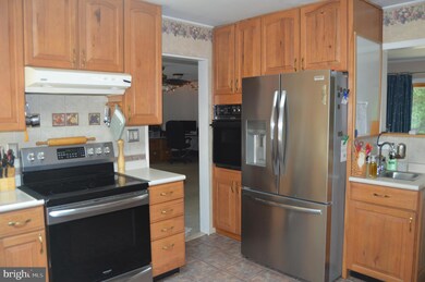
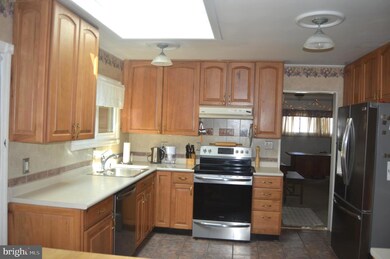
Welcome to 30 Fieldstone Rd – A Spacious, Well-Maintained Home Full of Natural Light and Comfort
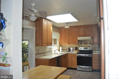
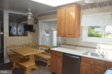
This generously sized home offers the perfect blend of space, functionality, and charm. The main floor features a bright and open kitchen with abundant cabinet space, two sinks for added convenience, a sleek flat cooktop and oven with a separate wall oven, stainless steel refrigerator and dishwasher, and a skylight that fills the room with natural light. Just off the kitchen, the dining room opens to the backyard via sliding glass doors, creating a great flow for indoor-outdoor entertaining.
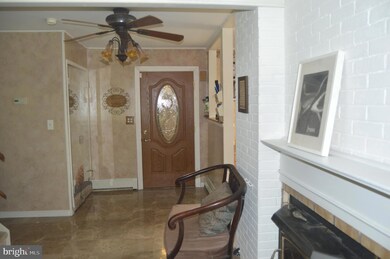
The spacious living room includes custom built-in shelving, while a large family room provides plenty of space for relaxing or gathering with loved ones. The main level also includes three bedrooms, including a primary suite with a private, updated full bath and another skylight. A second full, updated hall bath and a laundry room with shelving complete the main floor.
Upstairs, you’ll find a fourth bedroom, a full bathroom, and a large, light-filled great room with yet another skylight—ideal for a home office, playroom, or guest suite.
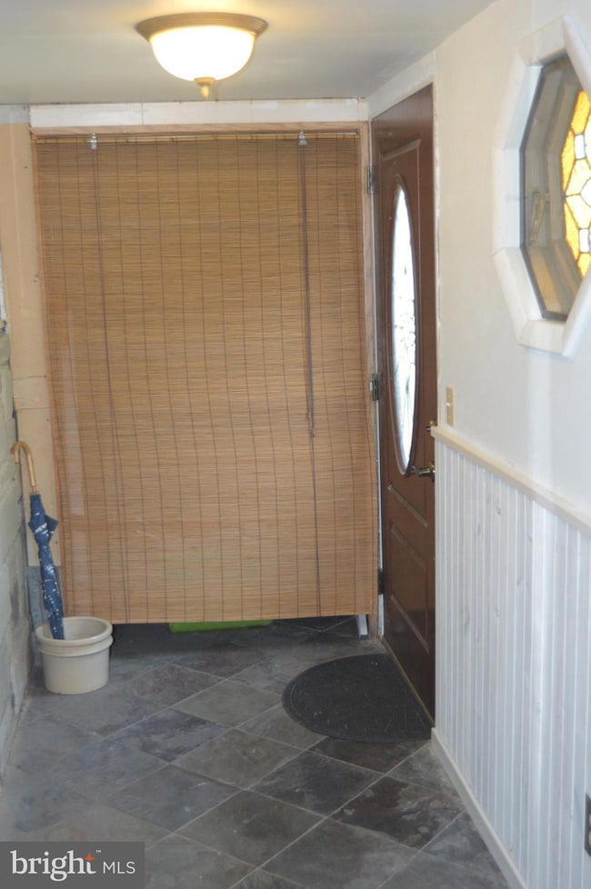
Outside, enjoy a beautifully landscaped yard, a private back patio perfect for entertaining, and an attached storage area for added convenience. A two-car garage completes the package. Roof was replaced in 2024. Pull down stairs to attic storage located in the family room.
Don't miss this opportunity to own a spacious, move-in ready home in a desirable neighborhood in the Neshaminy School District.
Last Agent to Sell the Property
(215) 395-6277 info@opuselitere.com Opus Elite Real Estate License #RS-198078-L Listed on: 08/04/2025
Last Buyer's Agent
(215) 395-6277 info@opuselitere.com Opus Elite Real Estate License #RS271670
| Date | Type | Sale Price | Title Company |
|---|---|---|---|
| Deed | $535,000 | Equity One Abstract | |
| Deed | $129,900 | -- | |
| Quit Claim Deed | -- | -- |
| Date | Status | Loan Amount | Loan Type |
|---|---|---|---|
| Open | $428,000 | New Conventional | |
| Previous Owner | $103,900 | No Value Available |
| Date | Event | Price | List to Sale | Price per Sq Ft |
|---|---|---|---|---|
| 09/18/2025 09/18/25 | Sold | $535,000 | +1.9% | $195 / Sq Ft |
| 08/07/2025 08/07/25 | Pending | -- | -- | -- |
| 08/04/2025 08/04/25 | For Sale | $525,000 | -- | $191 / Sq Ft |
| Year | Tax Paid | Tax Assessment Tax Assessment Total Assessment is a certain percentage of the fair market value that is determined by local assessors to be the total taxable value of land and additions on the property. | Land | Improvement |
|---|---|---|---|---|
| 2025 | $6,684 | $30,700 | $6,160 | $24,540 |
| 2024 | $6,684 | $30,700 | $6,160 | $24,540 |
| 2023 | $6,577 | $30,700 | $6,160 | $24,540 |
| 2022 | $6,405 | $30,700 | $6,160 | $24,540 |
| 2021 | $6,405 | $30,700 | $6,160 | $24,540 |
| 2020 | $6,328 | $30,700 | $6,160 | $24,540 |
| 2019 | $6,187 | $30,700 | $6,160 | $24,540 |
| 2018 | $6,073 | $30,700 | $6,160 | $24,540 |
| 2017 | $5,918 | $30,700 | $6,160 | $24,540 |
| 2016 | $5,918 | $30,700 | $6,160 | $24,540 |
| 2015 | $6,107 | $30,700 | $6,160 | $24,540 |
| 2014 | $6,107 | $30,700 | $6,160 | $24,540 |
D
Seller's Agent in 2025
Deborah Ramagli
Opus Elite Real Estate
(215) 512-5382
2 in this area
12 Total Sales

Seller Co-Listing Agent in 2025
Joseph Ramagli
Opus Elite Real Estate
(215) 932-0197
1 in this area
18 Total Sales
J
Buyer's Agent in 2025
John Krapf
Opus Elite Real Estate
1 in this area
18 Total Sales
Source: Bright MLS
MLS Number: PABU2102176
APN: 22-054-114
Disclaimer: Certain information contained herein is derived from information provided by parties other than Homes.com. All information provided is deemed reliable, but is not guaranteed to be accurate and should be independently verified.
![]() The data relating to real estate for sale on this website appears in part through the BRIGHT Internet Data Exchange program, a voluntary cooperative exchange of property listing data between licensed real estate brokerage firms, and is provided by BRIGHT through a licensing agreement.
The data relating to real estate for sale on this website appears in part through the BRIGHT Internet Data Exchange program, a voluntary cooperative exchange of property listing data between licensed real estate brokerage firms, and is provided by BRIGHT through a licensing agreement.
Listing information is from various brokers who participate in the Bright MLS IDX program and not all listings may be visible on the site.
The property information being provided on or through the website is for the personal, non-commercial use of consumers and such information may not be used for any purpose other than to identify prospective properties consumers may be interested in purchasing.
Some properties which appear for sale on the website may no longer be available because they are for instance, under contract, sold or are no longer being offered for sale.
Property information displayed is deemed reliable but is not guaranteed.
Copyright 2026 Bright MLS, Inc.
Ask me questions while you tour the home.