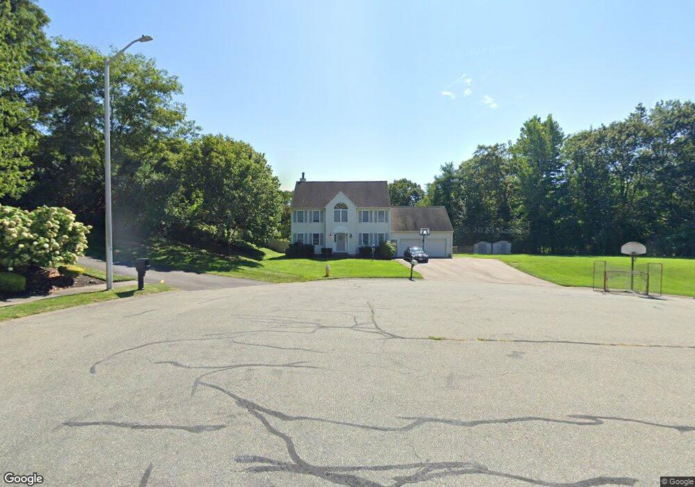
30 High Point Way Wrentham, MA 02093
Estimated Value: $796,000 - $960,000
4
Beds
3
Baths
3,196
Sq Ft
$283/Sq Ft
Est. Value
About This Home
This home is located at 30 High Point Way, Wrentham, MA 02093 and is currently estimated at $904,430, approximately $282 per square foot. 30 High Point Way is a home located in Norfolk County with nearby schools including Delaney Elementary School, Charles E Roderick, and The Sage School.
Ownership History
Date
Name
Owned For
Owner Type
Purchase Details
Closed on
May 17, 2017
Sold by
Connor Marianne L and Kennan Leila
Bought by
Connor Marianne L
Current Estimated Value
Purchase Details
Closed on
Mar 12, 2010
Sold by
Connor Marianne L and Connor Thomas M
Bought by
Connor Marianne L and Kennan Leila
Home Financials for this Owner
Home Financials are based on the most recent Mortgage that was taken out on this home.
Original Mortgage
$90,000
Interest Rate
5.02%
Mortgage Type
Purchase Money Mortgage
Create a Home Valuation Report for This Property
The Home Valuation Report is an in-depth analysis detailing your home's value as well as a comparison with similar homes in the area
Home Values in the Area
Average Home Value in this Area
Purchase History
| Date | Buyer | Sale Price | Title Company |
|---|---|---|---|
| Connor Marianne L | -- | -- | |
| Connor Marianne L | -- | -- |
Source: Public Records
Mortgage History
| Date | Status | Borrower | Loan Amount |
|---|---|---|---|
| Previous Owner | Connor Marianne L | $90,000 |
Source: Public Records
Tax History Compared to Growth
Tax History
| Year | Tax Paid | Tax Assessment Tax Assessment Total Assessment is a certain percentage of the fair market value that is determined by local assessors to be the total taxable value of land and additions on the property. | Land | Improvement |
|---|---|---|---|---|
| 2025 | $9,155 | $789,900 | $325,700 | $464,200 |
| 2024 | $8,884 | $740,300 | $325,700 | $414,600 |
| 2023 | $8,613 | $682,500 | $296,000 | $386,500 |
| 2022 | $7,788 | $569,700 | $227,800 | $341,900 |
| 2021 | $7,782 | $553,100 | $238,600 | $314,500 |
| 2020 | $7,912 | $555,200 | $215,200 | $340,000 |
| 2019 | $7,852 | $556,100 | $231,700 | $324,400 |
| 2018 | $7,107 | $499,100 | $232,000 | $267,100 |
| 2017 | $6,947 | $487,500 | $227,500 | $260,000 |
| 2016 | $6,839 | $478,900 | $220,900 | $258,000 |
| 2015 | $6,257 | $417,700 | $182,100 | $235,600 |
| 2014 | $6,193 | $404,500 | $175,100 | $229,400 |
Source: Public Records
Map
Nearby Homes
- 483 Thurston St
- 120 Hawes St
- 65 Pond St
- 80 Mill St
- 362 East St
- 11 Goodwin Dr
- 319 Taunton St
- 25 Foxboro Rd
- 1 Lorraine Metcalf Dr
- 406 South St
- 270 Dedham St
- 16 Treasure Island Rd
- 9 Oak Dr
- 10 Nature View Dr
- 15 Nature View Dr
- 11 Orchard Place Unit 11
- 160 Washington St Unit 36
- 14 Baker St
- 126 Washington St
- 130 Washington St
- 25 Old Quarry Rd
- 20 High Point Way
- 45 High Point Way
- 16 Old Quarry Rd
- 14 Old Quarry Rd
- 24 Old Quarry Rd
- 15 Old Quarry Rd
- 40 Old Quarry Rd
- 35 High Point Way
- 30 Old Quarry Rd
- 25 High Point Way
- 10 Granite Way
- 10 Oak Ridge Dr
- 10 Oak Ridge Dr Unit 1
- 20 Old Quarry Rd
- 20 Old Quarry Rd Unit 1
- 15 High Point Way
- 35 Old Quarry Rd
- 10 High Point Way
- 20 Oak Ridge Dr