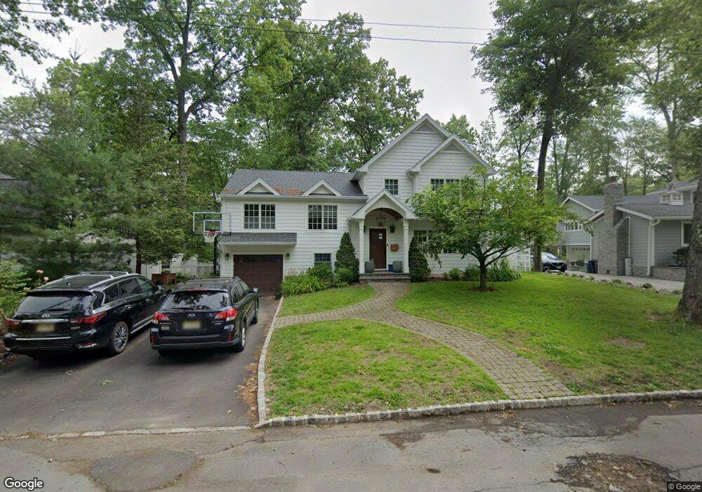
30 Karen Way Summit, NJ 07901
Estimated Value: $1,065,000 - $1,605,000
--
Bed
--
Bath
2,512
Sq Ft
$562/Sq Ft
Est. Value
About This Home
This home is located at 30 Karen Way, Summit, NJ 07901 and is currently estimated at $1,411,510, approximately $561 per square foot. 30 Karen Way is a home located in Union County with nearby schools including L C Johnson Summit Middle School, Summit Sr High School, and Kent Place School.
Ownership History
Date
Name
Owned For
Owner Type
Purchase Details
Closed on
Jul 29, 2011
Sold by
Adoutte David and Lecorre Keveren
Bought by
Coving Keith and Coving Theresa
Current Estimated Value
Purchase Details
Closed on
May 24, 2006
Sold by
Guirard Jean Paul
Bought by
Adoutte David and Corre Keveren
Home Financials for this Owner
Home Financials are based on the most recent Mortgage that was taken out on this home.
Original Mortgage
$568,000
Interest Rate
5.75%
Mortgage Type
Adjustable Rate Mortgage/ARM
Purchase Details
Closed on
Jun 6, 2001
Sold by
Mason Lucille Trace
Bought by
Guirard Jean Paul and Johnson Guirard Lori
Home Financials for this Owner
Home Financials are based on the most recent Mortgage that was taken out on this home.
Original Mortgage
$275,000
Interest Rate
7.2%
Create a Home Valuation Report for This Property
The Home Valuation Report is an in-depth analysis detailing your home's value as well as a comparison with similar homes in the area
Home Values in the Area
Average Home Value in this Area
Purchase History
| Date | Buyer | Sale Price | Title Company |
|---|---|---|---|
| Coving Keith | $610,000 | Fidelity Natl Title Ins Co | |
| Adoutte David | $710,000 | -- | |
| Guirard Jean Paul | $349,000 | -- |
Source: Public Records
Mortgage History
| Date | Status | Borrower | Loan Amount |
|---|---|---|---|
| Previous Owner | Adoutte David | $568,000 | |
| Previous Owner | Guirard Jean Paul | $275,000 |
Source: Public Records
Tax History Compared to Growth
Tax History
| Year | Tax Paid | Tax Assessment Tax Assessment Total Assessment is a certain percentage of the fair market value that is determined by local assessors to be the total taxable value of land and additions on the property. | Land | Improvement |
|---|---|---|---|---|
| 2025 | $16,387 | $376,200 | $141,100 | $235,100 |
| 2024 | $11,588 | $376,200 | $141,100 | $235,100 |
| 2023 | $11,588 | $267,800 | $141,100 | $126,700 |
| 2022 | $11,470 | $267,800 | $141,100 | $126,700 |
| 2021 | $11,561 | $267,800 | $141,100 | $126,700 |
| 2020 | $11,676 | $267,800 | $141,100 | $126,700 |
| 2019 | $11,689 | $267,800 | $141,100 | $126,700 |
| 2018 | $11,614 | $267,800 | $141,100 | $126,700 |
| 2017 | $11,689 | $267,800 | $141,100 | $126,700 |
| 2016 | $11,518 | $267,800 | $141,100 | $126,700 |
| 2015 | $11,293 | $267,800 | $141,100 | $126,700 |
| 2014 | $11,001 | $267,800 | $141,100 | $126,700 |
Source: Public Records
Map
Nearby Homes
- 180 Woodland Ave
- 37 Wade Dr
- 70 Canoe Brook Pkwy
- 147 Canoe Brook Pkwy
- 24 Greenfield Ave
- 2 Rose Ln
- 30 Aubrey St
- 180 Canoe Brook Pkwy
- 125 Hillcrest Ave
- 30 Wildwood Ln
- 57 Parrott Mill Rd
- 24 Gates Ave Unit A
- 412 Morris Ave Unit 17
- 60 Fernwood Rd
- 26 Ridge Rd
- 55 Oxbow Ln
- 172 Colonial Rd
- 166 Colonial Rd
- 67-75 New England Ave Unit 67D
- 50 Parmley Place Unit 203