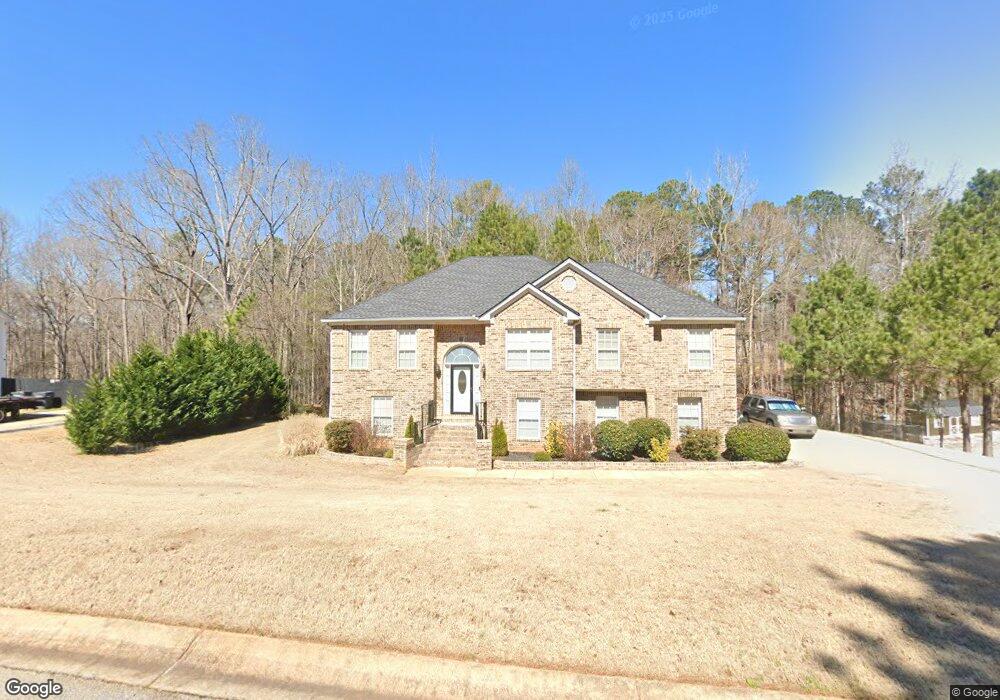
30 Lark Rd Covington, GA 30016
Estimated Value: $288,000 - $323,000
Studio
2
Baths
1,574
Sq Ft
$194/Sq Ft
Est. Value
About This Home
This home is located at 30 Lark Rd, Covington, GA 30016 and is currently estimated at $305,477, approximately $194 per square foot. 30 Lark Rd is a home located in Newton County with nearby schools including Oak Hill Elementary School, Veterans Memorial Middle School, and Alcovy High School.
Ownership History
Date
Name
Owned For
Owner Type
Purchase Details
Closed on
Apr 15, 2016
Sold by
Pyron Randy L
Bought by
Pyron Randy L and Pyron Annissa H
Current Estimated Value
Home Financials for this Owner
Home Financials are based on the most recent Mortgage that was taken out on this home.
Original Mortgage
$143,159
Outstanding Balance
$113,521
Interest Rate
3.87%
Mortgage Type
FHA
Estimated Equity
$191,956
Purchase Details
Closed on
Nov 26, 2001
Sold by
Rogers Fred
Bought by
Rogers Alethea H
Create a Home Valuation Report for This Property
The Home Valuation Report is an in-depth analysis detailing your home's value as well as a comparison with similar homes in the area
Home Values in the Area
Average Home Value in this Area
Purchase History
| Date | Buyer | Sale Price | Title Company |
|---|---|---|---|
| Pyron Randy L | -- | -- | |
| Pyron Randy L | $145,800 | -- | |
| Rogers Alethea H | -- | -- |
Source: Public Records
Mortgage History
| Date | Status | Borrower | Loan Amount |
|---|---|---|---|
| Open | Pyron Randy L | $143,159 | |
| Closed | Pyron Randy L | $143,159 |
Source: Public Records
Tax History
| Year | Tax Paid | Tax Assessment Tax Assessment Total Assessment is a certain percentage of the fair market value that is determined by local assessors to be the total taxable value of land and additions on the property. | Land | Improvement |
|---|---|---|---|---|
| 2025 | $3,316 | $137,960 | $17,480 | $120,480 |
| 2024 | $3,158 | $126,880 | $17,480 | $109,400 |
| 2023 | $3,051 | $114,760 | $8,800 | $105,960 |
| 2022 | $2,575 | $97,240 | $8,800 | $88,440 |
| 2021 | $2,818 | $95,440 | $8,800 | $86,640 |
| 2020 | $2,564 | $79,000 | $8,800 | $70,200 |
| 2019 | $2,161 | $66,080 | $8,800 | $57,280 |
| 2018 | $2,011 | $57,400 | $8,800 | $48,600 |
| 2017 | $1,753 | $49,880 | $8,800 | $41,080 |
| 2016 | $1,379 | $39,000 | $4,800 | $34,200 |
| 2015 | $1,299 | $36,680 | $4,000 | $32,680 |
| 2014 | $1,295 | $36,680 | $0 | $0 |
Source: Public Records
Map
Nearby Homes
- 2215 Oak Hill Rd
- 0 Goldfinch Dr Unit 10702928
- 0 Goldfinch Dr Unit 7728936
- 130 Goldfinch Dr
- 125 Goldfinch Dr
- 5240 Highway 20 S
- 5737 Highway 20 S
- 35 Fourwood Dr
- 20 W Forest Dr
- 6023 Highway 20 S
- 50 Butler Bridge Cir
- 110 Chapel Heights Way
- 2020 Bailey Creek Rd
- 170 Gibson Way
- 14908 Brown Bridge Rd
- 0 Butler Bridge Rd Unit 19792691
- 5214 Parkside Dr SE
- 307 Winding Stream Trail SW
- 30 Creekside Ct
- 255 Hugh Dr
Your Personal Tour Guide
Ask me questions while you tour the home.