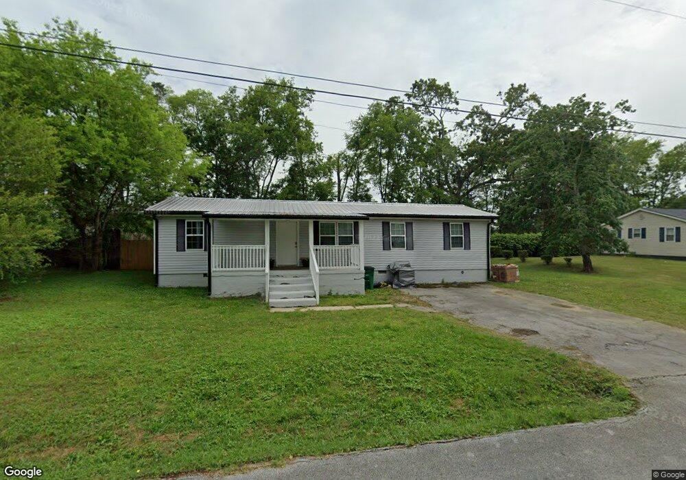
30 Lillian Dr Rossville, GA 30741
Westside NeighborhoodEstimated Value: $243,000 - $337,000
3
Beds
2
Baths
1,833
Sq Ft
$147/Sq Ft
Est. Value
About This Home
This home is located at 30 Lillian Dr, Rossville, GA 30741 and is currently estimated at $269,484, approximately $147 per square foot. 30 Lillian Dr is a home located in Catoosa County with nearby schools including West Side Elementary School, Lakeview Middle School, and Lakeview-Fort Oglethorpe High School.
Ownership History
Date
Name
Owned For
Owner Type
Purchase Details
Closed on
Jan 24, 2011
Sold by
Federal Home Loan Mortgage Corporation
Bought by
Chris King Properties Llc
Current Estimated Value
Purchase Details
Closed on
Sep 7, 2010
Sold by
Roberts George W And
Bought by
Chase Home Finance
Purchase Details
Closed on
Mar 5, 1990
Bought by
Roberts George W And
Create a Home Valuation Report for This Property
The Home Valuation Report is an in-depth analysis detailing your home's value as well as a comparison with similar homes in the area
Home Values in the Area
Average Home Value in this Area
Purchase History
| Date | Buyer | Sale Price | Title Company |
|---|---|---|---|
| Chris King Properties Llc | $26,000 | -- | |
| Chase Home Finance | -- | -- | |
| Roberts George W And | $31,500 | -- |
Source: Public Records
Tax History Compared to Growth
Tax History
| Year | Tax Paid | Tax Assessment Tax Assessment Total Assessment is a certain percentage of the fair market value that is determined by local assessors to be the total taxable value of land and additions on the property. | Land | Improvement |
|---|---|---|---|---|
| 2024 | $1,291 | $60,533 | $6,533 | $54,000 |
| 2023 | $1,086 | $48,495 | $6,533 | $41,962 |
| 2022 | $911 | $40,690 | $6,533 | $34,157 |
| 2021 | $851 | $40,690 | $6,533 | $34,157 |
| 2020 | $851 | $36,790 | $5,600 | $31,190 |
| 2019 | $860 | $36,790 | $5,600 | $31,190 |
| 2018 | $886 | $35,856 | $4,666 | $31,190 |
| 2017 | $857 | $34,676 | $4,666 | $30,010 |
| 2016 | $823 | $31,652 | $4,666 | $26,986 |
| 2015 | -- | $31,652 | $4,666 | $26,986 |
| 2014 | -- | $31,652 | $4,666 | $26,986 |
| 2013 | -- | $31,652 | $4,666 | $26,985 |
Source: Public Records
Map
Nearby Homes
- 72 Lillian Dr
- 5 Winchester Dr
- 527 Winchester Dr
- 398 Winchester Dr
- 385 Winchester Dr
- Peyton Plan at The Fields at Huntley Meadows
- Quail Run Plan at The Fields at Huntley Meadows
- Hawthorne Plan at The Fields at Huntley Meadows
- Silverton Plan at The Fields at Huntley Meadows
- Aspen Plan at The Fields at Huntley Meadows
- Hudson Plan at The Fields at Huntley Meadows
- Ocoee Plan at The Fields at Huntley Meadows
- Peachtree Plan at The Fields at Huntley Meadows
- 458 Winchester Dr
- 530 Winchester Dr
- 792 S MacK Smith Rd
- 518 Winchester Dr
- 602 MacK Smith Rd
- 302 Huntley Meadows Dr
- 98 Winchester Dr
- 52 Lillian Dr
- 397 Elizabeth St
- 49 Lillian Dr
- 69 Lillian Dr
- 394 Elizabeth St
- 92 Lillian Dr
- 87 Lillian Dr
- 563 Winchester Dr Unit 52
- 5 Winchester Dr Unit 51
- 108 Lillian Dr
- 42 Ann Dr
- 111 Lillian Dr
- 568 Winchester Dr Unit 86
- 321 Winchester Dr Unit 29
- 31 Winchester Dr
- 31 Winchester Dr Unit 49
- 124 Lillian Dr
- 2311 Winchester Dr
- 0 Winchester Dr Unit 36435352
- 0 Winchester Dr Unit 36435150