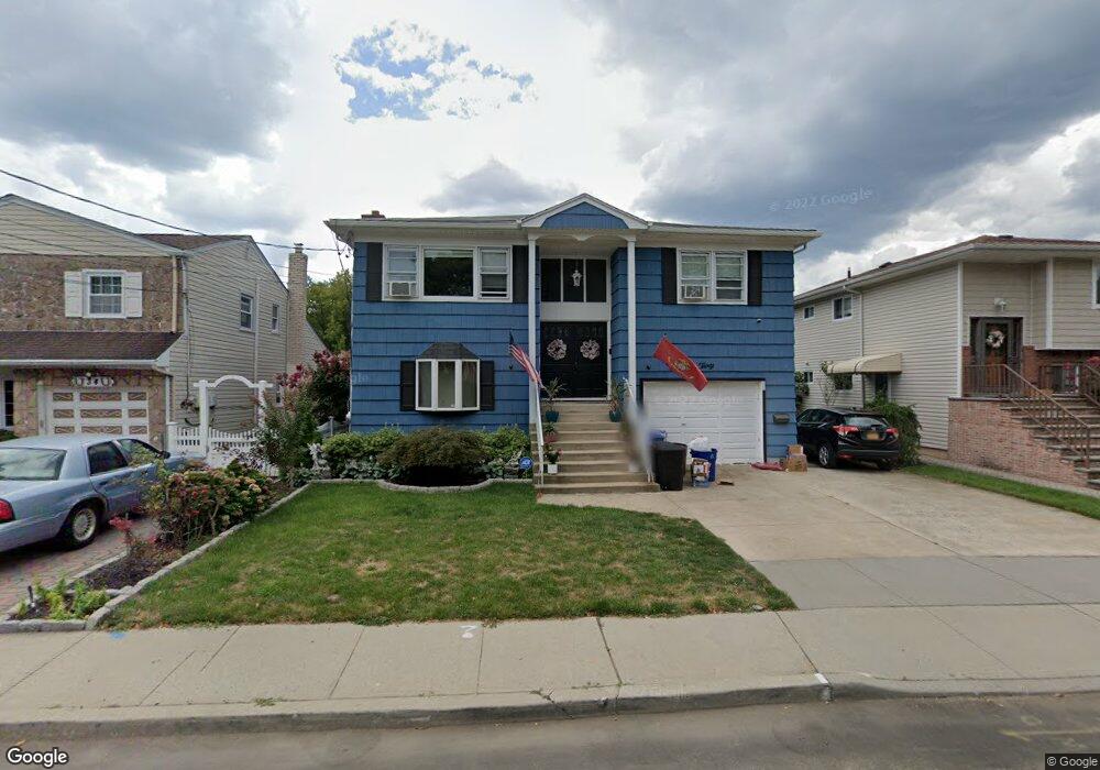
30 Maple Ave Lynbrook, NY 11563
Estimated Value: $960,000 - $1,018,528
2
Beds
1
Bath
1,060
Sq Ft
$933/Sq Ft
Est. Value
About This Home
This home is located at 30 Maple Ave, Lynbrook, NY 11563 and is currently estimated at $989,264, approximately $933 per square foot. 30 Maple Ave is a home located in Nassau County with nearby schools including Lynbrook Senior High School, Our Lady Of Peace School, and Holy Name of Mary School.
Ownership History
Date
Name
Owned For
Owner Type
Purchase Details
Closed on
Sep 25, 2015
Sold by
Reed Evelyn
Bought by
Morales Daniel and Morales Darlene
Current Estimated Value
Home Financials for this Owner
Home Financials are based on the most recent Mortgage that was taken out on this home.
Original Mortgage
$582,255
Outstanding Balance
$458,113
Interest Rate
3.88%
Mortgage Type
VA
Estimated Equity
$531,151
Purchase Details
Closed on
Oct 15, 1999
Sold by
Montalbano Gaetano and Montalbano Anna Maria
Bought by
Reed Evelyn
Home Financials for this Owner
Home Financials are based on the most recent Mortgage that was taken out on this home.
Original Mortgage
$198,000
Interest Rate
7.78%
Mortgage Type
Purchase Money Mortgage
Create a Home Valuation Report for This Property
The Home Valuation Report is an in-depth analysis detailing your home's value as well as a comparison with similar homes in the area
Home Values in the Area
Average Home Value in this Area
Purchase History
| Date | Buyer | Sale Price | Title Company |
|---|---|---|---|
| Morales Daniel | $570,000 | Commonwealth A Land Title | |
| Reed Evelyn | $305,000 | -- |
Source: Public Records
Mortgage History
| Date | Status | Borrower | Loan Amount |
|---|---|---|---|
| Open | Morales Daniel | $582,255 | |
| Previous Owner | Reed Evelyn | $198,000 |
Source: Public Records
Tax History
| Year | Tax Paid | Tax Assessment Tax Assessment Total Assessment is a certain percentage of the fair market value that is determined by local assessors to be the total taxable value of land and additions on the property. | Land | Improvement |
|---|---|---|---|---|
| 2025 | $15,643 | $678 | $211 | $467 |
| 2024 | $1,450 | $684 | $213 | $471 |
| 2023 | $15,989 | $759 | $236 | $523 |
| 2022 | $15,989 | $759 | $236 | $523 |
| 2021 | $22,552 | $739 | $230 | $509 |
| 2020 | $14,661 | $833 | $512 | $321 |
| 2019 | $12,890 | $833 | $480 | $353 |
| 2018 | $11,938 | $888 | $0 | $0 |
| 2017 | $12,073 | $1,205 | $569 | $636 |
| 2016 | $13,815 | $1,205 | $569 | $636 |
| 2015 | $1,789 | $1,205 | $569 | $636 |
| 2014 | $1,789 | $1,205 | $569 | $636 |
| 2013 | $1,642 | $1,205 | $569 | $636 |
Source: Public Records
Map
Nearby Homes
- 504 Merrick Rd Unit 4J
- 504 Merrick Rd Unit 4E
- 504 Merrick Rd Unit 2k
- 12 Roxy Place
- 232 Sherman St
- 57 Nieman Ave
- 3 Olive Place
- 2 Fowler Ave Unit 206
- 2 Fowler Ave Unit 228
- 189 Surrey Commons
- 29 Summit Ave
- 20 Daley Place Unit 128
- 30 Daley Place Unit 136
- 30 Daley Place Unit 247
- 20 Daley Place Unit 225
- 30 Daley Place Unit 146
- 21 Oceanview Ave
- 127 Smith St
- 229 E Hawthorne Ave
- 181 Walnut St
Your Personal Tour Guide
Ask me questions while you tour the home.