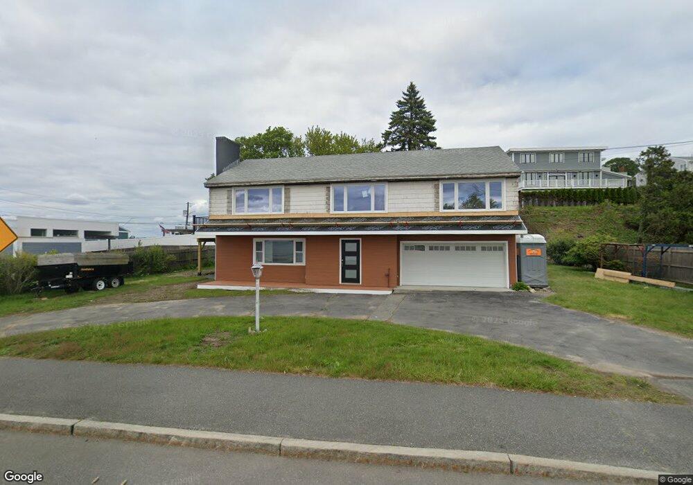
30 Nahant Rd Nahant, MA 01908
Estimated Value: $828,283 - $1,535,000
1
Bed
2
Baths
1,875
Sq Ft
$602/Sq Ft
Est. Value
About This Home
This home is located at 30 Nahant Rd, Nahant, MA 01908 and is currently estimated at $1,127,821, approximately $601 per square foot. 30 Nahant Rd is a home located in Essex County with nearby schools including Johnson Elementary School, Swampscott Middle School, and Swampscott High School.
Ownership History
Date
Name
Owned For
Owner Type
Purchase Details
Closed on
Jul 18, 2025
Sold by
Cox Louise A
Bought by
Oyeah Rt and Cox
Current Estimated Value
Purchase Details
Closed on
Jul 10, 2025
Sold by
30 Nahant Road Llc
Bought by
Cox Louise A
Purchase Details
Closed on
Jul 8, 2025
Sold by
Betty E Sarpi Irt and Sarpi-Brahm
Bought by
30 Nahant Road Llc
Purchase Details
Closed on
Apr 18, 2014
Sold by
Sarpi Vitina
Bought by
Betty F Sarpi Irt and Sarpi-Brahm
Purchase Details
Closed on
Jul 19, 2012
Sold by
Sarpi Vitina
Bought by
Betty E Sarpi Irt and Sarpi-Brahm
Purchase Details
Closed on
Apr 15, 2003
Sold by
Barrasso Emanuella
Bought by
Sarpi John
Create a Home Valuation Report for This Property
The Home Valuation Report is an in-depth analysis detailing your home's value as well as a comparison with similar homes in the area
Home Values in the Area
Average Home Value in this Area
Purchase History
| Date | Buyer | Sale Price | Title Company |
|---|---|---|---|
| Oyeah Rt | -- | -- | |
| Oyeah Rt | -- | -- | |
| Oyeah Rt | -- | -- | |
| Cox Louise A | $1,550,000 | -- | |
| Cox Louise A | $1,550,000 | -- | |
| Cox Louise A | $1,550,000 | -- | |
| 30 Nahant Road Llc | -- | -- | |
| 30 Nahant Road Llc | -- | -- | |
| 30 Nahant Road Llc | -- | -- | |
| Betty F Sarpi Irt | -- | -- | |
| Betty F Sarpi Irt | -- | -- | |
| Betty F Sarpi Irt | -- | -- | |
| Betty E Sarpi Irt | -- | -- | |
| Betty E Sarpi Irt | -- | -- | |
| Sarpi John | $200,000 | -- | |
| Sarpi John | $200,000 | -- |
Source: Public Records
Mortgage History
| Date | Status | Borrower | Loan Amount |
|---|---|---|---|
| Previous Owner | Sarpi John | $350,000 |
Source: Public Records
Tax History Compared to Growth
Tax History
| Year | Tax Paid | Tax Assessment Tax Assessment Total Assessment is a certain percentage of the fair market value that is determined by local assessors to be the total taxable value of land and additions on the property. | Land | Improvement |
|---|---|---|---|---|
| 2025 | $6,769 | $739,800 | $455,500 | $284,300 |
| 2024 | $6,534 | $720,400 | $436,100 | $284,300 |
| 2023 | $6,178 | $679,600 | $426,400 | $253,200 |
| 2022 | $6,142 | $627,400 | $397,300 | $230,100 |
| 2021 | $5,724 | $544,600 | $368,300 | $176,300 |
| 2020 | $5,972 | $544,400 | $368,300 | $176,100 |
| 2019 | $5,939 | $544,400 | $368,300 | $176,100 |
| 2018 | $5,580 | $544,400 | $368,300 | $176,100 |
| 2017 | $5,737 | $547,900 | $368,300 | $179,600 |
| 2016 | $6,190 | $588,400 | $416,700 | $171,700 |
| 2015 | $6,103 | $558,900 | $387,200 | $171,700 |
| 2014 | $5,822 | $527,800 | $351,800 | $176,000 |
Source: Public Records
Map
Nearby Homes
- 9 Little Nahant Rd
- 36 Lennox Rd
- 23 Phillips Rd
- 17 Pearl Rd
- 43 Maple Ave
- 66 Ocean St
- 2 Goddard Dr
- 183 Bass Point Rd
- 303 Nahant Rd
- 53 Lancaster Ave
- 98 Lynnway Unit 102
- 12 Chancery Ct Unit 205
- 12 Chancery Ct Unit 207
- 45 Tudor St Unit 3-8
- 9 Beach Rd Unit 4
- 41 Tudor St
- 154 Lynnway Unit 520
- 154 Lynnway Unit 205
- 154 Lynnway Unit 213
- 107 Lynnway